Jinchuan County or Quqên (Tibetan: ཆུ་ཆེན་རྫོང་།; Chinese: 金川县) is a county in the northwest of Sichuan Province, China. It is under the administration of the Ngawa Tibetan and Qiang Autonomous Prefecture. The seat of county is Dowu Town (Lewu[a]).
Jinchuan County
金川县 • ཆུ་ཆེན་རྫོང་། Quqên, Dajinchuan | |
|---|---|
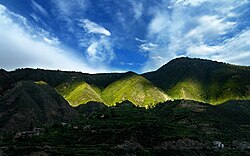
 Landscape near Jinchuan County | |
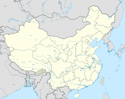
 Location of Jinchuan County (pink) and Ngawa Prefecture (yellow) within Sichuan Province | |
| Coordinates: 31°28′34″N 102°03′50″E / 31.476°N 102.064°E | |
| Country | China |
| Province | Sichuan |
| Autonomous prefecture | Ngawa |
| Seat | Dowu (Lewu) |
| Area | |
| • Total | 5,524 km2 (2,133 sq mi) |
| Population (2020)[1] | |
| • Total | 58,068 |
| • Density | 11/km2 (27/sq mi) |
| Time zone | UTC+8 (China Standard) |
| Website | www |
| Jinchuan County | |||||||||||
|---|---|---|---|---|---|---|---|---|---|---|---|
| Chinese name | |||||||||||
| Simplified Chinese | 金川县 | ||||||||||
| Traditional Chinese | 金川縣 | ||||||||||
| |||||||||||
| Tibetan name | |||||||||||
| Tibetan | ཆུ་ཆེན་རྫོང་། | ||||||||||
| |||||||||||
The county spans an area of 5,524 square kilometers, and has a population of about 73,000 as of 2019.[3]
Administrative divisions
editThe county is divided into 3 towns and 15 townships.[3][4] These township-level divisions are further divided into 112 village-level divisions.[3]
| Name | Simplified Chinese | Hanyu Pinyin | Tibetan | Wylie | Administrative division code | |
|---|---|---|---|---|---|---|
| Towns | ||||||
| Guangyinqiao Town (Tugqên) |
观音桥镇 | Guānyīnqiáo Zhèn | ཐུགས་ཆེན་གྲོང་རྡལ། | thugs chen grong rdal | 513226101 | |
| Anning Town (Anxing) |
安宁镇 | Ānníng Zhèn | ཨན་ཞིང་གྲོང་རྡལ། | an zhing grong rdal | 513226102 | |
| Dowu Town (Lewu) |
勒乌镇 | Lèwū Zhèn | མདོ་བུ་གྲོང་རྡལ། | mdo bu grong rdal | 513226103 | |
| Manai Town (Manê) |
马奈镇 | Mǎnài Zhèn | མ་ནེ་གྲོང་རྡལ། | ma ne grong rdal | 513226104 | |
| Townships | ||||||
| Sai Township (Sha'er) |
沙耳乡 | Shā'ěr Xiāng | གསལ་ཡུལ་ཚོ། | gsal yul tsho | 513226200 | |
| Qingning Township (Qênnying) |
庆宁乡 | Qìngníng Xiāng | ཆེན་ཉིང་ཡུལ་ཚོ། | chen nying yul tsho | 513226201 | |
| Kor Township (Ge'er) |
咯尔乡 | Gē'ěr Xiāng | གོར་ཡུལ་ཚོ། | gor yul tsho | 513226202 | |
| Hedong Township (Hodung) |
河东乡 | Hédōng Xiāng | ཧོ་ཏུང་ཡུལ་ཚོ། | ho tung yul tsho | 513226205 | |
| Hexi Township (Hoxi) |
河西乡 | Héxī Xiāng | ཧོ་ཞི་ཡུལ་ཚོ། | ho zhi yul tsho | 513226206 | |
| Gyêmo Township (Jimu) |
集沐乡 | Jímù Xiāng | ཀྱེ་མོ་ཡུལ་ཚོ། | kye mo yul tsho | 513226207 | |
| Sawa'gyo Township (Sawargyo, Sawajiao) |
撒瓦脚乡 | Sāwǎjiǎo Xiāng | ས་བར་ཀྱོ་ཡུལ་ཚོ། | sa bar kyo yul tsho | 513226208 | |
| Kara'gyo Township (Kalajiao) |
卡拉脚乡 | Kǎlājiǎo Xiāng | ཁ་ར་ཀྱོ་ཡུལ་ཚོ། | kha ra kyo yul tsho | 513226209 | |
| Osi Township (Ere) |
俄热乡 | Érè Xiāng | འོ་བཟི་ཡུལ་ཚོ། | vo bzi yul tsho | 513226210 | |
| Ganai Township (Ergali) |
二嘎里乡 | Èrgālǐ Xiāng | དགའ་གནས་ཡུལ་ཚོ། | dgav gnas yul tsho | 513226212 | |
| Akori Township (Akeli) |
阿科里乡 | Ākēlǐ Xiāng | ཨ་ཁོ་རི་ཡུལ་ཚོ། | a kho ri yul tsho | 513226213 | |
| Karsa Township (Kasa) |
卡撒乡 | Kǎsà Xiāng | མཁར་ས་ཡུལ་ཚོ། | mkhar sa yul tsho | 513226215 | |
| Zênda Township (Zengda) |
曾达乡 | Zēngdá Xiāng | རྩེ་མདའ་ཡུལ་ཚོ། | rtse mdav yul tsho | 513226216 | |
| Josum Township (Dusong) |
独松乡 | Dúsōng Xiāng | རྗོ་གསུམ་ཡུལ་ཚོ། | rjo gsum yul tsho | 513226217 | |
| Basi Township (Maori) |
毛日乡 | Máorì Xiāng | འབའ་ཟི་ཡུལ་ཚོ། | vbav zi yul tsho | 513226220 | |
History
editPrior to the 18th century, Greater Jinchuan was ruled by the Gyalrong Tibetan Chiefdom of Chuchen. In 1700, the kingdom of Trokyap submitted to the Qing rule. From 1747 to 1776, the Qing dynasty launched the Jinchuan campaigns to suppress the Jinchuan chiefdoms.
The county briefly belonged to the Revolutionary Government of Republic of Kerutetsa until 1935.[5] In 1950, the People's Liberation Army conquered the county.[5] The county was briefly renamed Dajinchuan County (simplified Chinese: 大金川县; traditional Chinese: 大金川縣) from 1953 to June 1959.[5]
Geography
editThe county is bordered by Barkam to the north, Xiaojin County to the east, Zamtang County to the west, and Dawu County and Danba County to the south.[3]
The county lies within the Dadu River basin.[5] 42% of the county is forested.[3]
Climate
edit| Climate data for Jinchuan, elevation 2,169 m (7,116 ft), (1991–2020 normals, extremes 1981–2010) | |||||||||||||
|---|---|---|---|---|---|---|---|---|---|---|---|---|---|
| Month | Jan | Feb | Mar | Apr | May | Jun | Jul | Aug | Sep | Oct | Nov | Dec | Year |
| Record high °C (°F) | 20.7 (69.3) |
27.8 (82.0) |
30.9 (87.6) |
35.0 (95.0) |
38.7 (101.7) |
36.6 (97.9) |
38.1 (100.6) |
38.0 (100.4) |
35.9 (96.6) |
33.3 (91.9) |
24.8 (76.6) |
18.5 (65.3) |
38.7 (101.7) |
| Mean daily maximum °C (°F) | 12.3 (54.1) |
16.5 (61.7) |
20.6 (69.1) |
23.5 (74.3) |
25.9 (78.6) |
26.8 (80.2) |
28.8 (83.8) |
29.2 (84.6) |
25.8 (78.4) |
21.3 (70.3) |
17.0 (62.6) |
12.5 (54.5) |
21.7 (71.0) |
| Daily mean °C (°F) | 2.7 (36.9) |
6.8 (44.2) |
11.1 (52.0) |
14.2 (57.6) |
16.8 (62.2) |
18.6 (65.5) |
20.2 (68.4) |
20.2 (68.4) |
17.4 (63.3) |
12.8 (55.0) |
7.4 (45.3) |
2.8 (37.0) |
12.6 (54.6) |
| Mean daily minimum °C (°F) | −3.4 (25.9) |
0.1 (32.2) |
4.3 (39.7) |
7.5 (45.5) |
10.8 (51.4) |
13.8 (56.8) |
15.3 (59.5) |
15.2 (59.4) |
13.0 (55.4) |
8.4 (47.1) |
1.7 (35.1) |
−3.0 (26.6) |
7.0 (44.6) |
| Record low °C (°F) | −9.7 (14.5) |
−6.9 (19.6) |
−5.7 (21.7) |
0.3 (32.5) |
2.1 (35.8) |
5.9 (42.6) |
8.0 (46.4) |
7.2 (45.0) |
5.2 (41.4) |
−1.2 (29.8) |
−6.1 (21.0) |
−10.7 (12.7) |
−10.7 (12.7) |
| Average precipitation mm (inches) | 2.1 (0.08) |
6.0 (0.24) |
19.7 (0.78) |
51.9 (2.04) |
97.5 (3.84) |
153.8 (6.06) |
119.1 (4.69) |
94.9 (3.74) |
117.5 (4.63) |
67.1 (2.64) |
8.9 (0.35) |
1.3 (0.05) |
739.8 (29.14) |
| Average precipitation days (≥ 0.1 mm) | 1.7 | 3.7 | 8.8 | 13.5 | 19.3 | 22.3 | 18.6 | 16.1 | 17.8 | 15.7 | 4.2 | 1.3 | 143 |
| Average snowy days | 2.3 | 2.9 | 0.6 | 0.1 | 0 | 0 | 0 | 0 | 0 | 0 | 0.4 | 1.1 | 7.4 |
| Average relative humidity (%) | 50 | 45 | 46 | 54 | 62 | 72 | 72 | 70 | 75 | 74 | 64 | 56 | 62 |
| Mean monthly sunshine hours | 182.3 | 169.5 | 191.6 | 197.8 | 200.8 | 165.2 | 181.9 | 190.6 | 163.9 | 167.3 | 175.1 | 184.9 | 2,170.9 |
| Percent possible sunshine | 57 | 54 | 51 | 51 | 47 | 39 | 42 | 47 | 45 | 48 | 56 | 59 | 50 |
| Source: China Meteorological Administration[6][7] | |||||||||||||
Notes and References
edit- ^ "阿坝州第七次全国人口普查公报第二号——县(市)人口情况" (in Chinese). Government of Ngawa Prefecture. 2021-06-11.[permanent dead link]
- ^ Government of Ngawa Prefecture. "勒乌镇".
- ^ a b c d e 金川概况 (in Chinese). Ngawa Tibetan and Qiang Autonomous Prefecture People's Government. 2019-09-06. Archived from the original on 2020-10-02. Retrieved 2020-10-02.
- ^ 2019年统计用区划代码 (in Chinese). National Bureau of Statistics of China. 2019. Archived from the original on 2020-10-02. Retrieved 2020-10-02.
- ^ a b c d 历史沿革 (in Chinese). Ngawa Tibetan and Qiang Autonomous Prefecture People's Government. 2019-12-10. Archived from the original on 2020-10-02. Retrieved 2020-10-02.
- ^ 中国气象数据网 – WeatherBk Data (in Simplified Chinese). China Meteorological Administration. Retrieved 13 April 2023.
- ^ 中国气象数据网 (in Simplified Chinese). China Meteorological Administration. Retrieved 13 April 2023.

