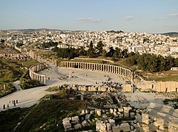
Jerash Governorate (Arabic: محافظة جرش) is one of 12 governorates in Jordan. It is located in the northwestern side of the country. The capital of the governorate is the city of Jerash.
Jerash Governorate
محافظة جرش Jarash Governorate | |
|---|---|
 The city of Jerash is the capital of Jerash Governorate | |
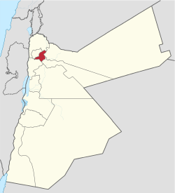
 Location of Jerash Governorate in Jordan | |
| Country | |
| Capital | Jerash |
| Government | |
| • Governor | Firas Faour |
| Area | |
• Total | 410 km2 (160 sq mi) |
| Population (2015) | |
• Total | 237,000 |
| • Density | 580/km2 (1,500/sq mi) |
| Time zone | GMT +2 |
| • Summer (DST) | +3 |
| Area code | +(962)2 |
| HDI (2021) | 0.715[1] high · 5th of 12 |
Jerash Governorate has the smallest area of the 12 governorates of Jordan, yet it has the second highest density in Jordan after Irbid Governorate. Jerash Governorate is ranked 7th by population.[2]
History
editIn the first century of the Christian era this insignificant city (then Gerasa) experienced a fast ascent under Roman rule and the Pax Romana. It became part of the Decapolis and grew increasingly competitive with the older Petra as a commercial town. The inhabitants extracted iron ore from the nearby Ajlun mountains.[3] Starting in the middle of the 1st century, this upswing led to active building and a rich abundance of architectural monuments, still impressive today. In the 2nd century, the Roman expansion wars in Asia led to further gains. Well-made roads were built to Pella, Philadelphia (now Amman), Dion and to the provincial capital Bos(t)ra. Emperor Hadrian visited the city in the winter of 129-130. In the following centuries the political situation in this region changed fundamentally and the city's means declined. During this time also Christianity was on the ascendant and many churches were built. Gerasa had its own bishop—still today it is a Titularbistum—and bishop Placcus (or Plancus) participated in the Council of Chalcedon.
The mathematician Nicomachus of Gerasa came from this city.
The Jerash Governorate was formed in 1994 from a portion of Irbid Governorate.
Geography
editThe province is bordered by Irbid Governorate to the north, Ajlun Governorate to the west, Mafraq Governorate and Zarqa Governorate to the east, and Amman and Balqa Governorate to the south.
The average yearly rainfall in the governorate is in the range of 400–600 mm considered among the highest in the country.[4] The elevation range of the province is 300 to 1247 m above sea level with fresh water streams and the Zarqa River flowing through it. The province is a mountainous area with a mild mediterranean climate.
Administrative divisions
editJerash Governorate consists of a single district (liwa'), Jerash Liwa, that is divided into three sub-districts (qda'):[5]
Cities and towns
editAside from the city of Jerash that gives the governorate its name, the governorate has many cities and towns: Souf, Sakib, Borma, Al-Mastaba, El-Kitté, Al-Haddadé, Bellila, Deir Il-Liyat, Nahlé, Il-Kfeir, Rashaida, Raimoun, An-Nabi Houd, Al-Jazzazah, Jubbah, Mirse', Muqbila, Al-Msheirfeh, Qafqafa, and others.
Refugee camps
editThere are two Palestinian refugee camps in Jerash Governorate, Souf camp near Souf and Gaza (Jerash) camp at Al Ḩaddādah.
Demographics
editThe national census of 2015 shows that the population of Jerash Governorate was 237,059 making up 2.49% of the population of Jordan. Around 70,000 were non-citizens, a figure including refugees.[6] This number is an increase by 54% on the population of the governorate in 2004, which was 153,602. Jordanian nationals made up 70.7% of the population in 2015. The foreign nationals who reside in Jerash Governorate made up only 2.38% of the foreign nationals in Jordan.
The population in 2004 was distributed as follows:
| No | Information | Jerash Governorate (2004) | Jordan (2004) |
|---|---|---|---|
| 1 | Total population | 153,602 | 5,350,000 |
| 2 | Growth rate | 2.1% | 2.3% |
| 3 | Male to female ratio | 51.48 to 48.52 | 51.5 to 48.5 |
| 4 | Ratio of Jordanians to foreign nationals | 87.1 to 12.9 | 93.0 to 7.0 |
| 5 | Persons per household | 5.9 | 5.3 |
| 6 | Population 15 years of age or older | 52% | 56% |
The population of districts according to census results:[7]
| District | Population (Census 1994) |
Population (Census 2004) |
Population (Census 2015) |
|---|---|---|---|
| Jerash Governorate | 123,190 | 153,602 | 237,059 |
| Qaṣabah Jarash | 123,190 | 153,602 | 237,059 |
Economy
editThe governorate's economy largely depends on commerce and tourism. Jerash is the second favorite tourist destination in Jordan. In addition to the historical sites, the governorate is also known for its forests that attract tourists. The governorate is also a main source of the highly educated and skilled workforce in Jordan. Jerash is equidistant (40 km) from the largest three cities in Jordan (Amman, Irbid and Zarqa), and this proximity makes the governorate a good business location. In addition, the province accounts of about 12% of olive oil production in Jordan.
Education
editJerash Governorate has two universities; Jerash Private University and Philadelphia University.
Gallery
edit-
Zarqa River passing through the governorate
-
Map of the governorate
-
Jerash Subdistrict Map
References
edit- ^ "Sub-national HDI - Area Database - Global Data Lab". hdi.globaldatalab.org. Retrieved 13 September 2018.
- ^ DoS Jordan Archived 12 October 2017 at the Wayback Machine
- ^ al-Amri, Yosha; Hauptmann, Andreas (2008). "The Iron Ore Mine of Mugharat el-Wardeh/Jordan in Southern Bilad al-Sham: Excavation and new dating". In Yalçin, Ünsal; Özbal, H.; Paşamehmetoğlu, AG (eds.). Ancient Mining in Turkey and The Eastern Mediterranean (PDF). Ankara: Atilim University. pp. 415–434. Archived from the original (PDF) on 2017-01-19.
- ^ Alrai Newspaper Archived 13 December 2009 at the Wayback Machine
- ^ Jordan Statistical Yearbook 2011 (PDF). Department of Statistics, Government of Jordan. 2011. p. 10. Archived from the original (PDF) on 19 January 2017. Retrieved 19 January 2017. Archived 19 January 2017 at the Wayback Machine
- ^ "Archived copy" (PDF). Archived from the original (PDF) on 28 March 2016. Retrieved 15 June 2016.
{{cite web}}: CS1 maint: archived copy as title (link) Archived 28 March 2016 at the Wayback Machine Jordan National Census of 2015 (Arabic) - ^ "Jordan: Administrative Division, Governorates and Districts". citypopulation.de. Retrieved 25 December 2016.