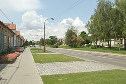
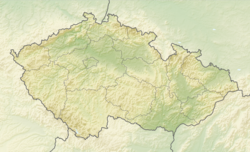
Hovorany (German: Howoran) is a municipality and village in Hodonín District in the South Moravian Region of the Czech Republic. It has about 2,200 inhabitants.
Hovorany | |
|---|---|
 Centre of Hovorany | |
| Coordinates: 48°57′18″N 16°59′36″E / 48.95500°N 16.99333°E | |
| Country | |
| Region | South Moravian |
| District | Hodonín |
| First mentioned | 1593 |
| Area | |
• Total | 20.99 km2 (8.10 sq mi) |
| Elevation | 193 m (633 ft) |
| Population (2024-01-01)[1] | |
• Total | 2,168 |
| • Density | 100/km2 (270/sq mi) |
| Time zone | UTC+1 (CET) |
| • Summer (DST) | UTC+2 (CEST) |
| Postal code | 696 12 |
| Website | www |
Geography
editHovorany is located about 14 kilometres (9 mi) northwest of Hodonín and 37 km (23 mi) southeast of Brno. It lies in the Kyjov Hills. The highest point is a hill at 281 m (922 ft) above sea level.
History
editThe first written mention of Hovorany is from 1593. It was founded by Jan IV of Lipá, who allowed Croat migrants to settle on his Hodonín estate. The Croats then gradually assimilated. Hovorany suffered greatly in 1605 (during the Bocskai uprising) and during the Thirty Years' War.[2]
Demographics
edit
|
|
| ||||||||||||||||||||||||||||||||||||||||||||||||||||||
| Source: Censuses[3][4] | ||||||||||||||||||||||||||||||||||||||||||||||||||||||||
Economy
editHovorany is known for viticulture. The municipality lies in the Slovácká wine sub-region.
Transport
editThere are no railways or major roads passing through the municipality.
Sights
editThe main landmark of Hovorany is the Church of Saint John the Baptist. It was built in the Baroque style in 1721–1725.[5]
References
edit- ^ "Population of Municipalities – 1 January 2024". Czech Statistical Office. 2024-05-17.
- ^ "Historie obce" (in Czech). Obec Hovorany. Retrieved 2024-04-01.
- ^ "Historický lexikon obcí České republiky 1869–2011" (in Czech). Czech Statistical Office. 2015-12-21.
- ^ "Population Census 2021: Population by sex". Public Database. Czech Statistical Office. 2021-03-27.
- ^ "Kostel sv. Jana Křtitele se sochou a náhrobkem" (in Czech). National Heritage Institute. Retrieved 2024-04-01.


