Herblay-sur-Seine (French pronunciation: [ɛʁblɛ syʁ sɛn], lit. "Herblay-on-Seine"; before 2018: Herblay)[3] is a commune in the Val-d'Oise department in the Île-de-France region in Northern France. It is located 20.2 km (12.6 mi) from the centre of Paris, in its northwestern outer suburbs, on the departmental border with Yvelines. It is twinned with Yeovil, England.
Herblay-sur-Seine | |
|---|---|
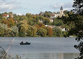
 The old village of Herblay, alongside the River Seine | |
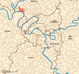
 Location (in red) within Paris inner and outer suburbs | |
| Coordinates: 48°59′27″N 2°09′59″E / 48.9908°N 2.1664°E | |
| Country | France |
| Region | Île-de-France |
| Department | Val-d'Oise |
| Arrondissement | Argenteuil |
| Canton | Herblay-sur-Seine |
| Intercommunality | CA Val Parisis |
| Government | |
| • Mayor (2020–2026) | Philippe Rouleau[1] |
| Area 1 | 12.74 km2 (4.92 sq mi) |
| Population (2021)[2] | 31,605 |
| • Density | 2,500/km2 (6,400/sq mi) |
| Time zone | UTC+01:00 (CET) |
| • Summer (DST) | UTC+02:00 (CEST) |
| INSEE/Postal code | 95306 /95220 |
| Elevation | 20–91 m (66–299 ft) |
| 1 French Land Register data, which excludes lakes, ponds, glaciers > 1 km2 (0.386 sq mi or 247 acres) and river estuaries. | |
Geography
editClimate
editHerblay-sur-Seine has an oceanic climate (Köppen climate classification Cfb). The average annual temperature in Herblay-sur-Seine is 11.8 °C (53.2 °F). The average annual rainfall is 612.5 mm (24.11 in) with October as the wettest month. The temperatures are highest on average in July, at around 19.7 °C (67.5 °F), and lowest in December, at around 4.6 °C (40.3 °F). The highest temperature ever recorded in Herblay-sur-Seine was 40.1 °C (104.2 °F) on 6 August 2003; the coldest temperature ever recorded was −13.5 °C (7.7 °F) on 7 January 2009.
| Climate data for Herblay-sur-Seine (1981−2010 normals, extremes 1989−2014) | |||||||||||||
|---|---|---|---|---|---|---|---|---|---|---|---|---|---|
| Month | Jan | Feb | Mar | Apr | May | Jun | Jul | Aug | Sep | Oct | Nov | Dec | Year |
| Record high °C (°F) | 16.0 (60.8) |
20.5 (68.9) |
24.6 (76.3) |
27.0 (80.6) |
32.5 (90.5) |
36.8 (98.2) |
37.2 (99.0) |
40.1 (104.2) |
32.5 (90.5) |
29.4 (84.9) |
19.0 (66.2) |
17.7 (63.9) |
40.1 (104.2) |
| Mean daily maximum °C (°F) | 7.2 (45.0) |
8.8 (47.8) |
12.8 (55.0) |
15.4 (59.7) |
19.8 (67.6) |
22.7 (72.9) |
25.1 (77.2) |
25.1 (77.2) |
21.2 (70.2) |
16.1 (61.0) |
10.7 (51.3) |
7.0 (44.6) |
16.0 (60.8) |
| Daily mean °C (°F) | 4.6 (40.3) |
5.5 (41.9) |
8.6 (47.5) |
10.6 (51.1) |
14.6 (58.3) |
17.4 (63.3) |
19.7 (67.5) |
19.6 (67.3) |
16.1 (61.0) |
12.4 (54.3) |
7.7 (45.9) |
4.6 (40.3) |
11.8 (53.2) |
| Mean daily minimum °C (°F) | 2.1 (35.8) |
2.2 (36.0) |
4.3 (39.7) |
5.8 (42.4) |
9.5 (49.1) |
12.2 (54.0) |
14.2 (57.6) |
14.1 (57.4) |
11.1 (52.0) |
8.5 (47.3) |
4.7 (40.5) |
2.1 (35.8) |
7.6 (45.7) |
| Record low °C (°F) | −13.5 (7.7) |
−12.8 (9.0) |
−9.7 (14.5) |
−3.0 (26.6) |
0.3 (32.5) |
2.1 (35.8) |
5.9 (42.6) |
5.2 (41.4) |
2.3 (36.1) |
−3.5 (25.7) |
−9.9 (14.2) |
−11.6 (11.1) |
−13.5 (7.7) |
| Average precipitation mm (inches) | 45.3 (1.78) |
44.2 (1.74) |
45.2 (1.78) |
50.7 (2.00) |
53.2 (2.09) |
51.8 (2.04) |
54.6 (2.15) |
51.7 (2.04) |
42.8 (1.69) |
61.3 (2.41) |
51.4 (2.02) |
60.3 (2.37) |
612.5 (24.11) |
| Average precipitation days (≥ 1.0 mm) | 9.0 | 9.3 | 9.9 | 10.0 | 9.0 | 8.6 | 7.9 | 8.1 | 8.1 | 9.6 | 10.8 | 11.1 | 111.0 |
| Source: Météo-France[4] | |||||||||||||
Demographics
edit
|
| ||||||||||||||||||||||||||||||||||||||||||||||||||||||||||||||||||||||||||||||||||||||||||||||||||||||||||||||||||
| |||||||||||||||||||||||||||||||||||||||||||||||||||||||||||||||||||||||||||||||||||||||||||||||||||||||||||||||||||
| Source: EHESS[5] and INSEE (1968–2020)[6] | |||||||||||||||||||||||||||||||||||||||||||||||||||||||||||||||||||||||||||||||||||||||||||||||||||||||||||||||||||
Transport
editHerblay-sur-Seine is served by Herblay station on the Transilien Paris-Saint-Lazare suburban rail line.
Education
editSchools in Herblay-sur-Seine:[7]
- Six primary school : Jean-Louis Etienne, Jean Moulin, Buttes Blanches, Chênes, Tournade, Saint-Exupéry
- Seven public preschools (maternelles): Jean Moulin, Buttes Blanches, Chênes, Tournade, Saint-Exupéry, Louis Pergaud, Jean Jaurès
- Seven public elementary schools: Jean Moulin, Pasteur, Buttes Blanches, Chênes, Saint Exupéry, Marie Curie, Jean Jaurès
- Two public junior high schools (collèges): Georges Duhamel and Jean Vilar
- Lycée Montesquieu (public senior high school/sixth-form college)
- Three private schools: Sainte Jeanne d'Arc, Montaigne, Léonard de Vinci
The commune has a municipal library.[8]
People from Herblay
edit- Pierre Pincemaille (1956-2018), musician and organist.
See also
editReferences
edit- ^ "Répertoire national des élus: les maires". data.gouv.fr, Plateforme ouverte des données publiques françaises (in French). 2 December 2020.
- ^ "Populations légales 2021" (in French). The National Institute of Statistics and Economic Studies. 28 December 2023.
- ^ Décret n° 2018-956 5 November 2018 (in French)
- ^ "Fiche Climatologique Statistiques 1981-2010 et records" (PDF) (in French). Météo-France. Retrieved August 28, 2022.
- ^ Des villages de Cassini aux communes d'aujourd'hui: Commune data sheet Herblay, EHESS (in French).
- ^ Population en historique depuis 1968, INSEE
- ^ "Etablissements scolaires." Herblay. Retrieved on September 6, 2016.
- ^ Home page. Herblay library. Retrieved on September 6, 2016.
External links
edit- Official website (in French)
- Pictures Quais de Seine (in English)
- Universite inter-Ages Herblay (in French)
- Base Mérimée: Search for heritage in the commune, Ministère français de la Culture. (in French)
- Association of Mayors of the Val d'Oise (in French)


