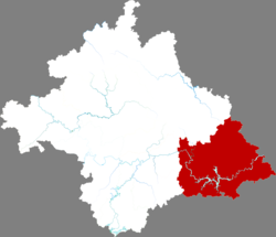
Hengzhou (Chinese: 横州; pinyin: Héngzhōu Shì), formerly, Heng County or Hengxian (simplified Chinese: 横县; traditional Chinese: 橫縣; pinyin: Héng Xiàn; Standard Zhuang: Hwngz Yen) is a county-level city of Guangxi Zhuang Autonomous Region, China; it is under the administration of the prefecture-level city of Nanning, the capital of Guangxi, with a permanent population of 863,001 and a hukou population of 1,200,521[4] as of the 2010 Census.
Hengzhou
横州市 · Hwngzcouh Si | |
|---|---|
 Location in Nanning | |
| Coordinates: 22°40′48″N 109°15′41″E / 22.6799°N 109.2614°E[1] | |
| Country | China |
| Autonomous region | Guangxi |
| Prefecture-level city | Nanning |
| Municipal seat | Hengzhou (横州镇) |
| Area | |
• Total | 3,464 km2 (1,337 sq mi) |
| Elevation | 56 m (185 ft) |
| Population (2010)[3] | |
• Total | 863,001 |
| • Density | 250/km2 (650/sq mi) |
| Time zone | UTC+8 (China Standard) |
| Postal code | 5303XX |
The easternmost county-level division of Nanning City, it borders the prefecture-level cities of Guigang to the northeast, Yulin to the east, and Qinzhou to the south. The county-level city was approved and elevated by the former Heng County by the State Council on February 3, 2021.
60% speak Pinghua as their mother tongue and a further 30% speak Pingua as a second language.[5]
Administrative divisions
editThere are 16 towns and 1 township in the county-level city:[6]
Towns:
- Hengzhou (横州镇), Luancheng (峦城镇), Liujing (六景镇), Shitang (石塘镇), Taoxu (陶圩镇), Xiaoyi (校椅镇), Yunbiao (云表镇), Baihe (百合镇), Nayang (那阳镇), Nanxiang (南乡镇), Xinfu (新福镇), Liantang (莲塘镇), Pingma (平马镇), Maling (马岭镇), Mashan (马山镇), Pinglang (平朗镇)
Township:
- , Zhenlong Township (镇龙乡)
Climate
edit| Climate data for Hengzhou (1991–2020 normals, extremes 1981–present) | |||||||||||||
|---|---|---|---|---|---|---|---|---|---|---|---|---|---|
| Month | Jan | Feb | Mar | Apr | May | Jun | Jul | Aug | Sep | Oct | Nov | Dec | Year |
| Record high °C (°F) | 28.5 (83.3) |
32.9 (91.2) |
33.1 (91.6) |
34.8 (94.6) |
35.8 (96.4) |
37.5 (99.5) |
38.5 (101.3) |
38.0 (100.4) |
37.9 (100.2) |
35.2 (95.4) |
32.9 (91.2) |
30.8 (87.4) |
38.5 (101.3) |
| Mean daily maximum °C (°F) | 16.5 (61.7) |
18.5 (65.3) |
21.1 (70.0) |
26.6 (79.9) |
30.4 (86.7) |
32.0 (89.6) |
32.8 (91.0) |
32.8 (91.0) |
31.5 (88.7) |
28.5 (83.3) |
24.2 (75.6) |
19.0 (66.2) |
26.2 (79.1) |
| Daily mean °C (°F) | 12.4 (54.3) |
14.5 (58.1) |
17.3 (63.1) |
22.5 (72.5) |
26.1 (79.0) |
27.8 (82.0) |
28.3 (82.9) |
28.1 (82.6) |
26.7 (80.1) |
23.5 (74.3) |
19.1 (66.4) |
14.2 (57.6) |
21.7 (71.1) |
| Mean daily minimum °C (°F) | 9.6 (49.3) |
11.7 (53.1) |
14.7 (58.5) |
19.6 (67.3) |
22.9 (73.2) |
24.9 (76.8) |
25.3 (77.5) |
25.0 (77.0) |
23.4 (74.1) |
19.8 (67.6) |
15.5 (59.9) |
10.9 (51.6) |
18.6 (65.5) |
| Record low °C (°F) | 0.8 (33.4) |
0.9 (33.6) |
2.7 (36.9) |
7.5 (45.5) |
13.9 (57.0) |
18.1 (64.6) |
20.1 (68.2) |
20.5 (68.9) |
15.1 (59.2) |
9.4 (48.9) |
5.1 (41.2) |
−0.5 (31.1) |
−0.5 (31.1) |
| Average precipitation mm (inches) | 53.2 (2.09) |
45.2 (1.78) |
86.6 (3.41) |
98.0 (3.86) |
192.1 (7.56) |
259.7 (10.22) |
273.9 (10.78) |
220.5 (8.68) |
139.5 (5.49) |
72.3 (2.85) |
62.3 (2.45) |
41.3 (1.63) |
1,544.6 (60.8) |
| Average precipitation days (≥ 0.1 mm) | 10.3 | 11.0 | 15.8 | 13.5 | 15.4 | 17.6 | 17.7 | 16.6 | 11.3 | 6.4 | 7.0 | 7.4 | 150 |
| Average relative humidity (%) | 77 | 79 | 83 | 81 | 80 | 83 | 82 | 83 | 80 | 75 | 74 | 72 | 79 |
| Mean monthly sunshine hours | 68.4 | 55.4 | 47.8 | 83.2 | 137.0 | 134.1 | 178.2 | 180.8 | 174.5 | 172.2 | 137.3 | 113.8 | 1,482.7 |
| Percent possible sunshine | 20 | 17 | 13 | 22 | 33 | 33 | 43 | 46 | 48 | 48 | 42 | 34 | 33 |
| Source: China Meteorological Administration[7][8] | |||||||||||||
References
edit- ^ "Hengxian" (Map). Google Maps. Retrieved 2014-07-02.
- ^ Nanning City Land Use Plan (2006–20)/《南宁市土地利用总体规划(2006-2020年)》.(in Chinese) Accessed 8 July 2014.
- ^ 《中国2010年人口普查分县资料》 (in Chinese). China Statistics Print. December 2012. ISBN 978-7-5037-6659-6.
- ^ 《中华人民共和国全国分县市人口统计资料2010》. 群众出版社. November 2011. ISBN 978-7-5014-4917-0.
- ^ Yu Jin (余谨), ed. (2016). 广西平话研究. p. 88f. ISBN 978-7-5161-8896-5.
- ^ 2023年统计用区划代码和城乡划分代码:横州市 (in Simplified Chinese). National Bureau of Statistics of China.
- ^ 中国气象数据网 – WeatherBk Data (in Simplified Chinese). China Meteorological Administration. Retrieved 28 May 2023.
- ^ 中国气象数据网 (in Simplified Chinese). China Meteorological Administration. Retrieved 28 May 2023.
