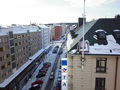
Hallituskatu is an east–west street running through the districts of Nalkala and Kaakinmaa,[1][2] in the centre of Tampere, Finland. Its end point in the east is the cartboard factory area of Metsä Board Tako.

The street name Hallituskatu (literally translated "government street") dates from 1807, when it was created as a result of committee work. It is one of the oldest street names in Tampere. The name model may have been a Stockholm street name, as it is known that there were no other Hallituskatus in Finland's major cities at that time. There is also no local justification for using the name.[3]
Along Hallituskatu are Tampere Workers' Hall,[4] Tampere Market Hall,[5] The Aamulehti Building[6][7] and three school buildings.
See also
editSources
editMedia related to Hallituskatu (Tampere) at Wikimedia Commons
- Louhivaara, Maija (1999). Tampereen kadunnimet. Tampere: Tampereen museot. ISBN 951-609-105-9. (in Finnish)
References
edit- ^ Keskustan pyörätiet ja -parkit (in Finnish)
- ^ Tampereen keskustan rakennettu kulttuuriympäristö 2012 (in Finnish)
- ^ Louhivaara 1999, p. 57. (in Finnish)
- ^ Tampereen kantakaupungin rakennuskulttuuri 1998, p. 93. (in Finnish)
- ^ Tampereen kantakaupungin rakennuskulttuuri 1998, p. 72. (in Finnish)
- ^ Tampereen kantakaupungin rakennuskulttuuri 1998, p. 75. (in Finnish)
- ^ Aamulehti uudessa toimitalossaan. Aamulehti. 1 December 1927, p. 4. Kansalliskirjaston digitaaliset aineistot (in Finnish)
61°29′46″N 23°45′11″E / 61.49611°N 23.75306°E