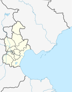
Guangkai Subdistrict (simplified Chinese: 广开街道; traditional Chinese: 廣開街道; pinyin: Guǎngkāi Jiēdào) is a subdistrict on the northern part of Nankai District, Tianjin, China. It borders Lingdangge Subdistrict to its north, Gulou and Xingnan Subdistircts to its east, Wanxing Subdistrict to its south, and Changhong Subdistrict to its west. In the year 2010, the subdistrict was home to 73,299 residents.[1]
Guangkai Subdistrict
广开街道 | |
|---|---|
 Guangkai'er Road within the subdistrict, 2014 | |
 Location in Nankai District | |
| Coordinates: 39°07′45″N 117°09′46″E / 39.12917°N 117.16278°E | |
| Country | China |
| Municipality | Tianjin |
| District | Nankai |
| Village-level Divisions | 13 communities |
| Area | |
| • Total | 1.72 km2 (0.66 sq mi) |
| Elevation | 6 m (20 ft) |
| Population (2010) | |
| • Total | 73,299 |
| • Density | 43,000/km2 (110,000/sq mi) |
| Time zone | UTC+8 (China Standard) |
| Postal code | 300102 |
| Area code | 022 |
History
edit| Year | Status | Part of |
|---|---|---|
| 1954 - 1956 | Xushuichi Subdistrict
Ximennan Subdistrict Liuhe Shichang Subdistrict Dongshengli Subdistrict |
7th District, Tianjin |
| 1956 - 1958 | Nankai District, Tianjin | |
| 1958 - 1960 | Xushuichi Subdistrict
Ximennan Subdistrict Dongshengli Subdistrict | |
| 1960 - 1962 | Xushuichi People's Commune
Ximennan People's Commune Dongshengli People's Commune | |
| 1962 - 1966 | Xushuichi Subdistrict
Ximennan Subdistrict Liuhe Shichang Subdistrict Dongshengli Subdistrict | |
| 1966 - 1968 | Dongfanghong District, Tianjin | |
| 1968 - 1978 | Ximennan Subdistrict | Nankai District, Tianjin |
| 1978 - 1999 | Xushuichi Subdistrict
Ximennan Subdistrict Liuhe Shichang Subdistrict Dongshengli Subdistrict | |
| 1999 - present | Guangkai Subdistrict |
Administrative divisions
editAs of 2021, Guangkai Subdistrict was made up of 13 residential communities. They are listed in the table below:[3]
| Subdivision Names | Name Transliterations |
|---|---|
| 桦林园 | Hualinyuan |
| 朝园里 | Chaoyuanli |
| 颂禹里 | Songyuli |
| 康舜里 | Kangshunli |
| 级升里 | Jishengli |
| 卫安西里 | Wei'an Xili |
| 卫安中里 | Wei'an Zhongli |
| 新丽里 | Xinlili |
| 瑞德里 | Ruideli |
| 凯兴天宝公寓 | Kaixing Tianbao Gongyu |
| 格调春天 | Gediao Chuntian |
| 宝龙湾 | Baolongwan |
| 风荷天江 | Fenghe Tianjiang |
Gallery
edit-
Huanghe Avenue, 2011
-
Fuxinzhuang Catheral, 2011
-
Street view of Fuxinzhuang Avenune, 2014
-
Changjiang Avenue, 2014
References
edit- ^ "China: Tiānjīn Municipal Province (Districts and Townships) - Population Statistics, Charts and Map". www.citypopulation.de. Retrieved 2022-11-05.
- ^ 中华人民共和国政区大典:天津市卷 (in Chinese). 中国社会出版社. 2020.
- ^ "2021年统计用区划代码和城乡划分代码". www.stats.gov.cn. Retrieved 2022-11-20.

