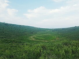
Geomeun Oreum (Korean: 검은 오름; Hanja: 黑岳), popularly called Geum Oreum (금오름; 今岳) and alternately called Geumak (금악; 今岳),[1][2] is an oreum (small extinct volcano; parasitic cone) in Hallim, Jeju City, Jeju Province, South Korea.[3]
| Geomeun Oreum | |
|---|---|
| Geum Oreum, Geumak | |
 The marshy area at the top (August 2017) | |
| Highest point | |
| Elevation | 427 m (1,401 ft) |
| Coordinates | 33°21′21″N 126°18′20″E / 33.3559°N 126.3056°E |
| Geography | |
 | |
| Location | Hallim, Jeju City, Jeju Province, South Korea |
Toponymy
editThe oreum's name possibly refers to the color black, in reference to its dark soil. "Geom" may also mean "god", suggesting that the oreum had an important local spiritual role.[2]
Description
editIts highest point is 427 m (1,401 ft) above sea level. It has a height from base of 178 m (584 ft), and covers an area of 613,966 m2 (6,608,680 sq ft). It has a conical shape.[3] There is a cell tower at the summit, as well as a guard post.[2]
There is a caldera around 52 m (171 ft) deep[4] at the top of the mountain called Wangmae or Ammae (왕메; 암메).[3] It has an area of 30,000 pyeong (99,000 m2).[2] Within the crater is a marshy area that develops a pond after rain. This area is called Geumakdam (금악담; 今岳潭).[3][5][2] Amphibians live in this marshy area and have been affected by human activity at the top.[5][4]
The oreum is on privately-owned land.[6] Before 2009, livestock used to graze on the oreum; they were relocated in order to accommodate the safety of tourists.[6] The owners of the oreum dispose of waste on the oreum and maintain its infrastructure.[6]
It is popular for tourists, as it is normally possible to drive up to the summit. From the top, tourists can engage in paragliding.[7][8][2] A 2017 news article reported that driving up to the very top was restricted.[6] The top reportedly has views of Hallasan and Sanbangsan.[2] In 2017, it was reported that the oreum had an influx of popularity after it was featured in a TV program.[6][1] For other publicly-owned oreum, such as Yongnuni Oreum, the local government enacted halts on tourist activity in order to safeguard the environment. As this oreum is privately owned, the owners declined to do so.[1] There is also a trail that goes up the oreum, and one through its forests. The forest trail opened in 2009.[2]
During the 1910–1945 Japanese colonial period, tunnels were dug into the oreum. Locals hid inside these tunnels during the 1948 Jeju uprising.[7]
References
edit- ^ a b c 박, 미라 (2017-09-24). "'방송 탄 뒤 유명세' 제주 오름, 불법 주차·탐방로 훼손 '몸살'". Kyunghyang Shinmun (in Korean). Retrieved 2024-07-13.
- ^ a b c d e f g h "[오름이야기]금오름". 제주환경일보 (in Korean). 2017-02-21. Retrieved 2024-07-13.
- ^ a b c d 오, 창명. "검은 오름[금악리] - 디지털제주문화대전". Encyclopedia of Korean Local Culture (in Korean). Retrieved 2024-07-13.
- ^ a b 고, 성식 (2024-01-29). "제주 금오름에 또 쌓이는 돌탑에 맹꽁이 "나 죽어요"". Yonhap News Agency (in Korean). Retrieved 2024-07-13.
- ^ a b Lee, M. H. (2024-04-15). "Jeju Island Stone Piles Cleared to Protect Amphibian Habitats on Geum Oreum". The Korea Bizwire. Retrieved 2024-07-13.
- ^ a b c d e "제주 금오름 방송 등장에 유모차 등반까지 '시끌벅적'". 제주의소리 (in Korean). 2017-09-25. Retrieved 2024-07-13.
- ^ a b 현, 봉철 (2018-06-17). "'밟고 선 땅 아래가 망자 무덤'…삶의 터전을 잃다". New Jeju Ilbo (in Korean). Retrieved 2024-07-13.
- ^ "Geumak (Geum) Oreum Volcanic Cone". www.visitjeju.net. Retrieved 2024-07-13.