Firuzkuh County (Persian: شهرستان فیروزکوه) is in Tehran province, Iran. Its capital is the city of Firuzkuh.[3]
Firuzkuh County
Persian: شهرستان فیروزکوه | |
|---|---|
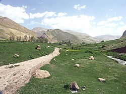
 Landscape near Tang-e Vashi | |
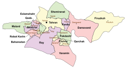
 Location of Firuzkuh County in Tehran province (right, yellow) | |
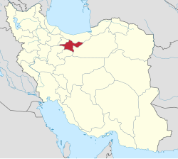
 Location of Tehran province in Iran | |
| Coordinates: 35°39′N 52°42′E / 35.650°N 52.700°E[1] | |
| Country | |
| Province | Tehran |
| Capital | Firuzkuh |
| Districts | Central, Arjomand |
| Area | |
| • Total | 2,386 km2 (921 sq mi) |
| Population (2016)[2] | |
| • Total | 33,558 |
| • Density | 14/km2 (36/sq mi) |
| Time zone | UTC+3:30 (IRST) |
| Firuzkuh County can be found at GEOnet Names Server, at this link, by opening the Advanced Search box, entering "9206116" in the "Unique Feature Id" form, and clicking on "Search Database". | |
Demographics
editPopulation
editAt the time of the 2006 National Census, the county's population was 37,416 in 10,414 households.[4] The following census in 2011 counted 38,712 people in 11,828 households.[5] The 2016 census measured the population of the county as 33,558 in 11,700 households.[2]
Administrative divisions
editFiruzkuh County's population history and administrative structure over three consecutive censuses are shown in the following table.
| Administrative division | 2006[4] | 2011[5] | 2016[2] |
|---|---|---|---|
| Central District | 29,036 | 32,359 | 27,056 |
| Hablerud RD | 4,884 | 3,983 | 2,883 |
| Poshtkuh RD | 4,560 | 4,267 | 2,745 |
| Shahrabad RD | 3,785 | 3,738 | 3,975 |
| Firuzkuh (city) | 15,807 | 20,371 | 17,453 |
| Arjomand District | 8,380 | 6,353 | 6,502 |
| Doboluk RD | 3,761 | 3,676 | 3,475 |
| Qazqanchay RD | 2,931 | 1,563 | 1,903 |
| Arjomand (city) | 1,688 | 1,114 | 1,124 |
| Total | 37,416 | 38,712 | 33,558 |
| RD = rural district | |||
Climate
editAccording to the information of the State Meteorological Organization of Iran, the long-term average annual rainfall of Firuzkuh is around 342.9 mm.[6]
See also
editMedia related to Firuzkuh County at Wikimedia Commons
References
edit- ^ OpenStreetMap contributors (19 September 2024). "Firuzkuh County" (Map). OpenStreetMap (in Persian). Retrieved 19 September 2024.
- ^ a b c Census of the Islamic Republic of Iran, 1395 (2016): Tehran Province. amar.org.ir (Report) (in Persian). The Statistical Center of Iran. Archived from the original (Excel) on 12 December 2021. Retrieved 19 December 2022.
- ^ Habibi, Hassan (c. 2014) [Approved 18 September 1375]. Creation of units of national divisions in the citizenship of Tehran province. rc.majlis.ir (Report) (in Persian). Ministry of the Interior, Political-Defense Commission of the Government Board. Notification 121295/T17174K. Archived from the original on 18 June 2014. Retrieved 27 December 2023 – via Islamic Parliament Research Center.
- ^ a b Census of the Islamic Republic of Iran, 1385 (2006): Tehran Province. amar.org.ir (Report) (in Persian). The Statistical Center of Iran. Archived from the original (Excel) on 20 September 2011. Retrieved 25 September 2022.
- ^ a b Census of the Islamic Republic of Iran, 1390 (2011): Tehran Province. irandataportal.syr.edu (Report) (in Persian). The Statistical Center of Iran. Archived from the original (Excel) on 20 January 2023. Retrieved 19 December 2022 – via Iran Data Portal, Syracuse University.
- ^ https://tehranmet.ir/uploads/tahghighat/140201.pdf [bare URL PDF]