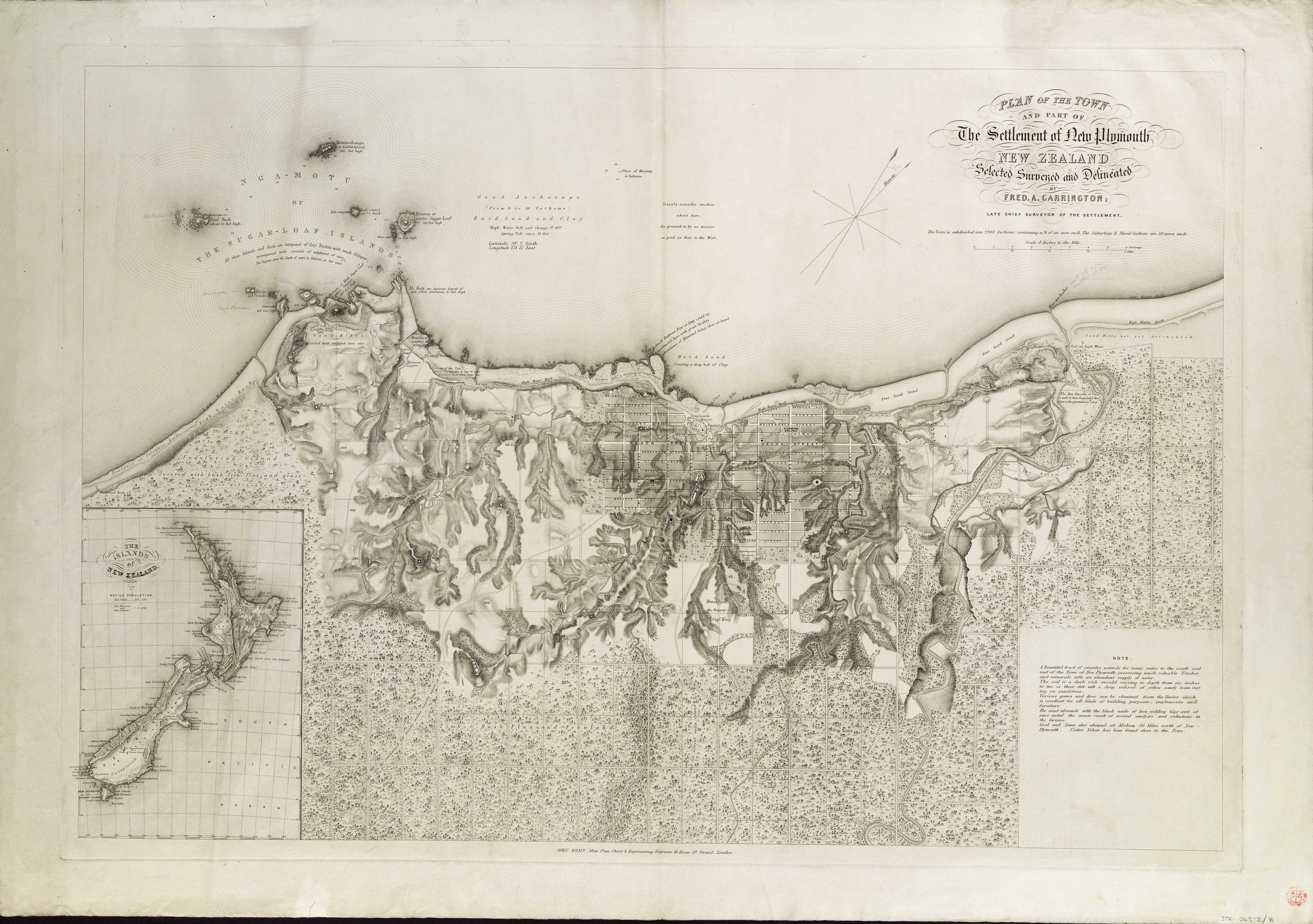
File:Plan of the town and part of the settlement of New Plymouth, New Zealand, selected surveyed and delineated by Fred. A.Carrington; late Chief Surveyor of the settlement. RMG F0149.tiff

Size of this JPG preview of this TIF file: 800 × 563 pixels. Other resolutions: 320 × 225 pixels | 640 × 450 pixels | 1,024 × 721 pixels | 1,280 × 901 pixels | 2,560 × 1,802 pixels | 7,339 × 5,165 pixels.
Original file (7,339 × 5,165 pixels, file size: 108.45 MB, MIME type: image/tiff)
| This is a file from the Wikimedia Commons. Information from its description page there is shown below. Commons is a freely licensed media file repository. You can help. |
Summary
| Author |
Carrington, Fred A; John Brain |
| Description |
English: Plan of the town and part of the settlement of New Plymouth, New Zealand, selected surveyed and delineated by Fred. A.Carrington; late Chief Surveyor of the settlement.Single sheet. Engr. Scale: 1:15 840. Cartographic Note: Ungraduated. North at 30 degrees. Scale 4 inches to the mile. Contents Note: Shows the land divided into rectangular plots with a street grid in the town. Text extols the beauty and resources of the country. Inset: The Islands of New Zealand [ca. 1:15 000 000]. STK263:2/8 New Plymouth NZ by Carrington |
| Date | [circa 1850] |
| Dimensions | Printed area 52 x 76cm, on sheet 62 x 83cm. |
| Source/Photographer | http://collections.rmg.co.uk/collections/objects/540718 |
| Permission (Reusing this file) |
The original artefact or artwork has been assessed as public domain by age, and faithful reproductions of the two dimensional work are also public domain. No permission is required for reuse for any purpose. The text of this image record has been derived from the Royal Museums Greenwich catalogue and image metadata. Individual data and facts such as date, author and title are not copyrightable, but reuse of longer descriptive text from the catalogue may not be considered fair use. Reuse of the text must be attributed to the "National Maritime Museum, Greenwich, London" and a Creative Commons CC-BY-NC-SA-3.0 license may apply if not rewritten. Refer to Royal Museums Greenwich copyright. |
| Identifier | Acquisition Number: N.60-4 Acquisition Number: NA1960-4 id number: STK263:2/8 |
| Collection | Charts and maps |
Licensing
|
This is a faithful photographic reproduction of a two-dimensional, public domain work of art. The work of art itself is in the public domain for the following reason:
The official position taken by the Wikimedia Foundation is that "faithful reproductions of two-dimensional public domain works of art are public domain".
This photographic reproduction is therefore also considered to be in the public domain in the United States. In other jurisdictions, re-use of this content may be restricted; see Reuse of PD-Art photographs for details. | ||||
File history
Click on a date/time to view the file as it appeared at that time.
| Date/Time | Thumbnail | Dimensions | User | Comment | |
|---|---|---|---|---|---|
| current | 22:06, 29 August 2017 |  | 7,339 × 5,165 (108.45 MB) | Fæ | Royal Museums Greenwich Charts and maps, http://collections.rmg.co.uk/collections/objects/540718 |
File usage
The following pages on the English Wikipedia use this file (pages on other projects are not listed):