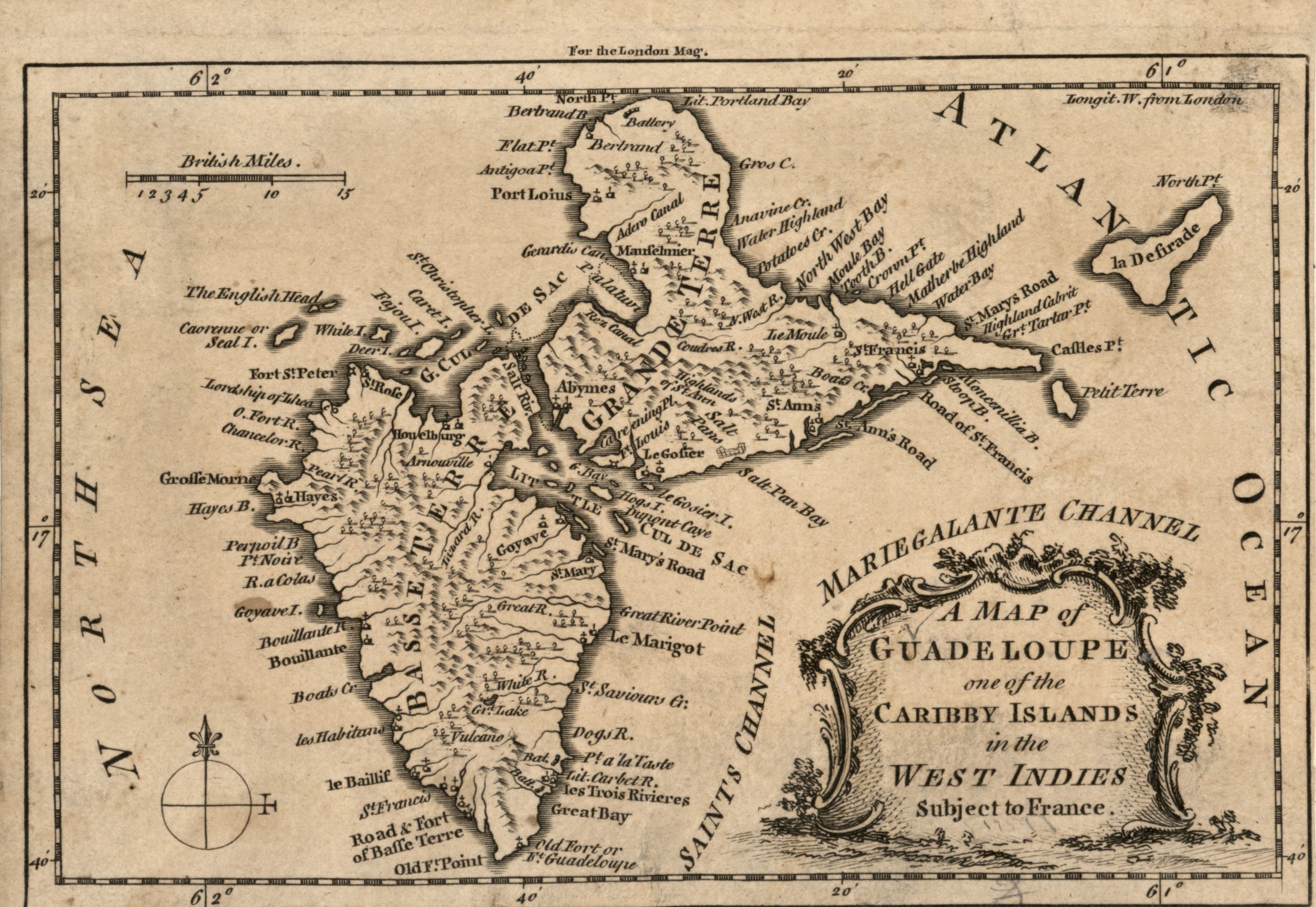
File:A map of Guadeloupe, one of the Caribby Islands in the West Indies subject to France. LOC 2010593357.tif

Size of this JPG preview of this TIF file: 800 × 551 pixels. Other resolutions: 320 × 221 pixels | 640 × 441 pixels | 1,024 × 706 pixels | 1,280 × 882 pixels | 2,905 × 2,002 pixels.
Original file (2,905 × 2,002 pixels, file size: 16.64 MB, MIME type: image/tiff)
| This is a file from the Wikimedia Commons. Information from its description page there is shown below. Commons is a freely licensed media file repository. You can help. |
Summary
| Description |
English: Relief shown pictorially. From London magazine, or, Gentleman's monthly intelligencer. March 1759, v. 28. In upper margin: For the London Mag. LC Maps of North America, 1750-1789, 2013 Available also through the Library of Congress Web site as a raster image. |
||
| Title | A map of Guadeloupe, one of the Caribby Islands in the West Indies subject to France. | ||
| Shelf ID | G5070 1759 .M2 | ||
| Date | |||
| Source | https://www.loc.gov/item/2010593357/ | ||
| Author | Unknown author | ||
| Permission (Reusing this file) |
|
||
| Other versions |
|
||
| Location | Guadeloupe | ||
| Part of | Military Battles And Campaigns · American Memory · Catalog · Geography And Map Division · American Revolution And Its Era: Maps And Charts Of North America And The West Indies, 1750-1789 | ||
| Subject | Maps · Early Works To 1800 · Guadeloupe |


Licensing
|
This is a faithful photographic reproduction of a two-dimensional, public domain work of art. The work of art itself is in the public domain for the following reason:
The official position taken by the Wikimedia Foundation is that "faithful reproductions of two-dimensional public domain works of art are public domain".
This photographic reproduction is therefore also considered to be in the public domain in the United States. In other jurisdictions, re-use of this content may be restricted; see Reuse of PD-Art photographs for details. | ||||
File history
Click on a date/time to view the file as it appeared at that time.
| Date/Time | Thumbnail | Dimensions | User | Comment | |
|---|---|---|---|---|---|
| current | 05:06, 25 May 2018 |  | 2,905 × 2,002 (16.64 MB) | Fæ | LOC Maps https://www.loc.gov/item/2010593357/ #14684 |
File usage
The following pages on the English Wikipedia use this file (pages on other projects are not listed):