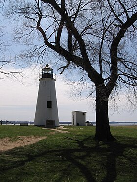
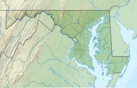
Elk Neck State Park is a public recreation area located between Chesapeake Bay and the Elk River near the southern tip of the Elk Neck Peninsula in Cecil County, Maryland. The state park is home to the historic Turkey Point Light and offers land-based and water-based recreation.[3] The park is located on MD 272, eight miles (13 km) south of the town of North East, and 13 miles (21 km) south of exit 100 on I-95. It is operated by the Maryland Department of Natural Resources.
| Elk Neck State Park | |
|---|---|
 | |
| Location | Cecil County, Maryland, United States |
| Nearest town | North East, Maryland |
| Coordinates | 39°29′14″N 75°59′24″W / 39.48722°N 75.99000°W[1] |
| Area | 2,369 acres (959 ha)[2] |
| Elevation | 262 ft (80 m)[1] |
| Established | 1936 |
| Administered by | Maryland Department of Natural Resources |
| Designation | Maryland state park |
| Website | Official website |

History
editThe park had its genesis when, in 1936, naturalist Dr. William Abbott bequeathed his holdings along the Elk River to the state for use as a state park. Although he originally intended the land to be a gift to the Boy Scouts, a meeting with State Forester Fred W. Besley in 1935 persuaded Abbott to change the terms of his will. Following the state's purchase of additional acreage, the Civilian Conservation Corps created park improvements from 1937 to 1941.[4]
Activities and amenities
edit- Turkey Point Lighthouse
Dating from 1833, the Turkey Point Lighthouse sits on a 100-foot (30 m) bluff overlooking the Upper Chesapeake Bay. The 35-foot (11 m) tower is a "private aid to navigation" maintained by a non-profit organization, Turkey Point Light Station, Inc., which offers weekend tours seasonally.[5]
- Campgrounds
The park offers more than 250 campsites, rustic cabins, camper cabins, and youth group sites.[6]
- Water recreation
The park offers a swimming beach, fishing, and crabbing, plus a boat launch and launch area for canoeing and kayaking.[7][8]
- Trails
The park has 12 miles (19 km) of trails for hiking and biking.[9]
| Trail Name | Length | Difficulty |
|---|---|---|
| White Banks Trail | 3 miles (4.8 km) | Difficult |
| Pond Loop | 1 mile (1.6 km) | Moderate |
| Beaver Marsh Loop | 4 miles (6.4 km) | Difficult |
| Lighthouse Trail | 2 miles (3.2 km) | Easy |
Ecology
editThe park is part of the Northeastern coastal forests ecoregion, with a landscape characterized by deep forests, bluffs, beaches, and marshlands.[10]
In popular culture
editThe park was used as a filming location for the 1997 Clint Eastwood movie Absolute Power,[11][12] The Curve,[13] and as the setting of an episode of the television series Hannibal.[citation needed]
References
edit- ^ a b "Mauldin Mountain". Geographic Names Information System. United States Geological Survey, United States Department of the Interior.
- ^ "DNR Lands Acreage Report" (PDF). Maryland Department of Natural Resources. Retrieved October 20, 2024.
- ^ "Elk Neck State Park". Maryland Department of Natural Resources. Retrieved December 10, 2013.
- ^ Demond, Lucia (December 1991). "The Elk Neck State Park" (PDF). Bulletin of the Historical Society of Cecil County. Elkington, Md. Retrieved December 16, 2019.
- ^ Duvall, Mike W. "History: Turkey Point Light Station". Turkey Point Light Station, Inc. Retrieved December 10, 2013.
- ^ "Elk River Camping Area". Elk Neck State Park. Maryland Department of Natural Resources. Retrieved July 16, 2015.
- ^ "North East Beach Area and Picnic Shelters". Elk Neck State Park. Maryland Department of Natural Resources. Retrieved December 16, 2019.
- ^ "Rogues Harbor Boat Launch Facility". Elk Neck State Park. Maryland Department of Natural Resources. Retrieved December 16, 2019.
- ^ "Trails at Elk Neck" (PDF). Maryland Department of Natural Resources. Retrieved November 3, 2017.
- ^ Olson, D.M.; Dinerstein, E.; et al. (2001). "Terrestrial Ecoregions of the World: A New Map of Life on Earth". BioScience. 51 (11): 933–938. doi:10.1641/0006-3568(2001)051[0933:TEOTWA]2.0.CO;2.
- ^ "Absolute Power (1997) Filming Locations". IMDB. Retrieved July 16, 2015.
- ^ "Absolute Power (1997)". Movie Tourist. August 26, 2012. Retrieved May 17, 2014.
- ^ "Dead Man's Curve (1998) Filming & Production". IMDB. Retrieved July 11, 2021.
External links
edit- Elk Neck State Park Maryland Department of Natural Resources
- Elk Neck State Park Map Maryland Department of Natural Resources
- Turkey Point Light Station Turkey Point Light Station, Inc.
