Dzhankoi Raion (Ukrainian: Джанкойський район, Russian: Джанкойский район, Crimean Tatar: Canköy rayonı) is one of the 25 regions of Crimea, currently subject to a territorial dispute between the Russian Federation and Ukraine. Population: 68,429 (2014 Census).[1]
Dzhankoi District
Canköy rayonı | |
|---|---|
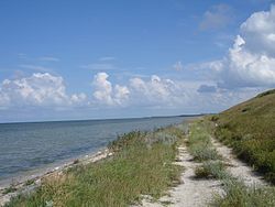
 Kalinovsky Nature Park, Dzhankoi District | |
 Dzhankoi Raion location within Crimea | |
| Country | |
| Region | |
| Capital | Dzhankoi |
| Subdivisions | List
|
| Area | |
• Total | 2,667 km2 (1,030 sq mi) |
| Population (2014) | |
• Total | 68,429 |
| • Density | 26/km2 (66/sq mi) |
| Time zone | UTC+3 (MSK) |
| Dialing code | +380-6564 |
| Website | dzhankoy-rayon |
It is located in the northern part of the Crimean steppe near the Syvash Bay. The city of Dzhankoi is the raion's administrative centre, but it is excluded from the region and forms a separate municipality. The North-Crimean canal (the main waterway of northern Crimea supplying the republic with water from the Dnieper river) runs through the district.
History
editOn 16 August 2022, during the Russian invasion of Ukraine, a large temporary ammunition store of the Russian forces in the villages of Maiske and Azovske was attacked causing secondary explosions and fires that burned into the next day. Russian government officials plan to offer amounts of "10, 50 and 100 thousand rubles" to local villagers whose houses were damaged, depending on the magnitude of damage to each structure.[2] The district frequently becomes the scene of pro-Ukrainian partisan warfare.[3][4][5]
2020 Ukrainian Administrative Reform
editIn July 2020, Ukraine conducted an administrative reform throughout its de jure territory. This included Crimea, which was at the time occupied by Russia, and is still ongoing as of October 2023. Crimea was reorganized from 14 raions and 11 municipalities into 10 raions, with municipalities abolished altogether. The territory of Dzhankoi Raion was expanded to also include the territories of the Municipality of Dzhankoi, but has not yet been implemented due to the ongoing Russian occupation.[6]
Demographics
editEthnic makeup of the district according to the 2001 Ukrainian census:[7]
References
edit- ^ Russian Federal State Statistics Service (2014). "Таблица 1.3. Численность населения Крымского федерального округа, городских округов, муниципальных районов, городских и сельских поселений" [Table 1.3. Population of Crimean Federal District, Its Urban Okrugs, Municipal Districts, Urban and Rural Settlements]. Федеральное статистическое наблюдение «Перепись населения в Крымском федеральном округе». ("Population Census in Crimean Federal District" Federal Statistical Examination) (in Russian). Federal State Statistics Service. Retrieved January 4, 2016.
- ^ In the north of Crimea, they continue to put out a fire at an ammunition depot, ForPost (новости Севастополь), in Russian, translation by Google, 17 August 2022.
- ^ "Plan "Perekhvat" ob"yavili v krymskom Dzhankoye" План "Перехват" объявили в крымском Джанкое. [The “Interception” plan was announced in the Crimean Dzhankoy.]. Breaking Mash (in Russian). 2024-02-27. Retrieved 2024-03-23 – via Telegram.
- ^ "Partisans: S-400 system and command post hit at Dzhankoi airfield". www.ukrinform.net. 2024-04-17. Retrieved 2024-05-23.
- ^ Security, Ellie Cook; Reporter, Defense (2024-04-17). "Crimea videos show huge explosions as Russian air base attacked". Newsweek. Retrieved 2024-05-23.
- ^ "Про утворення та ліквідацію районів". Офіційний вебпортал парламенту України (in Ukrainian). Retrieved 2023-10-16.
- ^ "Перепись". Archived from the original on 28 August 2012.
45°42′31″N 34°23′36″E / 45.70861°N 34.39333°E

