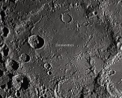
Deslandres is the heavily worn and distorted remains of a lunar impact crater. It is located to the southeast of the Mare Nubium, in the rugged southern highlands of the Moon. In dimension it is the third-largest crater formation on the visible Moon, being beaten only by Clavius (231 km) and by the 303-kilometer-diameter walled plain Bailly. The northern and eastern parts of the floor display a relatively level surface, but it is pock-marked with numerous craters. There is a small region of mare material, due to basaltic lava, along the eastern interior floor.
 Mosaic of Lunar Orbiter 4 images | |
| Coordinates | 32°33′S 5°34′W / 32.55°S 5.57°W |
|---|---|
| Diameter | 227 km |
| Depth | Unknown |
| Colongitude | 5° at sunrise |
| Eponym | Henri A. Deslandres |

The crater Walther is attached to the remnant of the eastern rim, and Ball intrudes into the southwestern rim. The crater remnant Lexell has broken across the southeastern rim, forming a "harbor" in the crater floor due to the wide gap in its northern rim. The irregular crater Regiomontanus is attached to the northeast rim of Deslandres. The crater Hell lies entirely within the western rim.
The satellite crater Hell Q lies at the center of a patch of higher albedo surface located in the eastern half of Deslandres. Around the time of the full moon this feature is one of the brightest spots on the lunar surface. The light hue indicates a relatively youthful feature in lunar geological terms. This patch is sometimes referred to as "Cassini's bright spot", as it was first mapped by Cassini in 1672 at the Paris Observatory.
This feature is so heavily eroded and degraded by overlapping impacts that it was not actually recognized as a crater formation until the 20th century. The name for this formation was suggested by Eugène M. Antoniadi in 1942, and was passed during the general assembly of the IAU in 1948.[1]
According to one version, Luna 5 impacted lunar surface in this crater (31°S 8°W / 31°S 8°W).[2]
The first released images from the Lunar Reconnaissance Orbiter in 2009 were of the area in the southern part of this crater.[3]
References
edit- ^ "Deslandres". Gazetteer of Planetary Nomenclature. USGS Astrogeology Research Program.
- ^ "Luna 5". NASA Space Science Data Coordinated Archive. 2014-08-26. Retrieved 2015-04-13.
- ^ Robert Garner (July 2, 2009). "LRO's First Moon Images". NASA. Archived from the original on 2009-08-08. Retrieved 2015-08-07.
- Wood, Chuck (2006-09-22). "Hell Plain". Lunar Photo of the Day. Archived from the original on 2007-09-27. Retrieved 2006-09-19.
- Wood, Chuck (2005-04-15). "A Floorful of History". Lunar Photo of the Day. Archived from the original on 2006-05-14. Retrieved 2006-07-21.
- Andersson, L. E.; Whitaker, E. A. (1982). NASA Catalogue of Lunar Nomenclature. NASA RP-1097.
- Bussey, B.; Spudis, P. (2004). The Clementine Atlas of the Moon. New York: Cambridge University Press. ISBN 978-0-521-81528-4.
- Cocks, Elijah E.; Cocks, Josiah C. (1995). Who's Who on the Moon: A Biographical Dictionary of Lunar Nomenclature. Tudor Publishers. ISBN 978-0-936389-27-1.
- McDowell, Jonathan (July 15, 2007). "Lunar Nomenclature". Jonathan's Space Report. Retrieved 2007-10-24.
- Menzel, D. H.; Minnaert, M.; Levin, B.; Dollfus, A.; Bell, B. (1971). "Report on Lunar Nomenclature by the Working Group of Commission 17 of the IAU". Space Science Reviews. 12 (2): 136–186. Bibcode:1971SSRv...12..136M. doi:10.1007/BF00171763. S2CID 122125855.
- Moore, Patrick (2001). On the Moon. Sterling Publishing Co. ISBN 978-0-304-35469-6.
- Price, Fred W. (1988). The Moon Observer's Handbook. Cambridge University Press. ISBN 978-0-521-33500-3.
- Rükl, Antonín (1990). Atlas of the Moon. Kalmbach Books. ISBN 978-0-913135-17-4.
- Webb, Rev. T. W. (1962). Celestial Objects for Common Telescopes (6th revised ed.). Dover. ISBN 978-0-486-20917-3.
- Whitaker, Ewen A. (1999). Mapping and Naming the Moon. Cambridge University Press. ISBN 978-0-521-62248-6.
- Wlasuk, Peter T. (2000). Observing the Moon. Springer. ISBN 978-1-85233-193-1.