Dango is a ghost town located in southwestern Jackson County, Kentucky, United States. The town was located at the confluence of Racoon Creek[2] and Horse Lick Creek, which flows into the Rockcastle River. It is located southwest of McKee by 8 miles, and 2.7 miles southeast of another ghost town, Loam.[3] Near the confluence of the two creeks is the historical Carpenter School,[4] which may be named after Carpenter Ridge,[5] of which it is two miles south of. Heavy settlement and farming occurred in the area around Horse Lick Creek, where Dango was, until the early 1900s.[6] The area where Dango was is currently occupied by the Daniel Boone National Forest, known as the Horse Lick Creek Biopreserve, with the majority of ownership being private.[7]
Dango, Kentucky | |
|---|---|
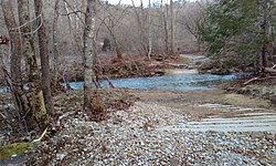
 Crossing at Horse Lick Creek at Dango, KY | |
| Coordinates: 37°22′10″N 84°06′53″W / 37.36944°N 84.11472°W | |
| Country | United States |
| State | Kentucky |
| County | Jackson |
| Elevation | 932 ft (284 m) |
| Time zone | UTC-5 (Eastern (EST)) |
| • Summer (DST) | UTC-4 (EST) |
| GNIS feature ID | [1] |

The town had a post office which opened up in 1907 and closed in 1926 or 1927.[9]
References
edit- ^ "Dango, Kentucky". Geographic Names Information System. United States Geological Survey, United States Department of the Interior.
- ^ "Dango, Kentucky". Geographic Names Information System. United States Geological Survey, United States Department of the Interior.
- ^ "Dango Populated Place Profile / Jackson County, Kentucky Data". HomeTownLocator. Retrieved March 23, 2020.
- ^ "Carpenter School". Geographic Names Information System. United States Geological Survey, United States Department of the Interior.
- ^ "Carpenter Ridge". Geographic Names Information System. United States Geological Survey, United States Department of the Interior.
- ^ "Daniel Boone National Forest - Special Places". United States Department of Agriculture - Forest Service. Retrieved March 23, 2020.
- ^ "Daniel Boone National Forest - Special Places". United States Department of Agriculture - Forest Service. Retrieved March 23, 2020.
- ^ "Dango Post Office (historical)". Geographic Names Information System. United States Geological Survey, United States Department of the Interior.
- ^ "Dango Post Office (historical)". Geographic Names Information System. United States Geological Survey, United States Department of the Interior.

