Cottontail Tower is a 5,980-foot-elevation (1,823-meter) pillar in Grand County, Utah, United States.
| Cottontail Tower | |
|---|---|
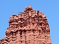
 Northwest aspect, centered | |
| Highest point | |
| Elevation | 5,980 ft (1,823 m)[1] |
| Prominence | 480 ft (146 m)[1] |
| Parent peak | Kingfisher Tower[1] |
| Isolation | 0.19 mi (0.31 km)[1] |
| Coordinates | 38°43′11″N 109°18′06″W / 38.719711°N 109.301702°W[2] |
| Naming | |
| Etymology | Cottontail |
| Geography | |
 Cottontail Tower Location in Utah  Cottontail Tower Cottontail Tower (the United States) | |
| Country | United States |
| State | Utah |
| County | Grand |
| Parent range | Colorado Plateau[2] |
| Topo map | USGS Fisher Towers |
| Geology | |
| Age of rock | Permian |
| Mountain type | Pillar |
| Type of rock | Sandstone |
| Climbing | |
| First ascent | 1967 |
| Easiest route | class 5.9[1] |
Description
editCottontail Tower is located 17 miles (27 km) northeast of Moab, Utah, in the Fisher Towers, on land administered by the Bureau of Land Management. Cottontail ranks as the second-steepest peak in the United States, second only to nearby The Titan.[3] Topographic relief is significant as the summit rises 800 feet (244 meters) above the tower's base.[4] Precipitation runoff from the tower drains to Onion Creek which empties into the Colorado River, approximately three miles to the west. Access is via Fisher Towers Road from Route 128, and hiking one mile on the Fisher Towers Trail.[4] This landform's descriptive toponym refers to the summit rock resembling the tail of a Cottontail rabbit.[5] Cottontail Tower is briefly shown (as a parachute flies by) in the opening scene of the film Austin Powers in Goldmember.[6]
Climbing
editThe first ascent of the summit was made June 11, 1967, by Harvey T. Carter, Art Howells, Mike Dudley, Don Doucette, Morgan Gadd, and Herbie Hendricks via the class 5.9 West Side Story route on the northwest side of the tower.[7]
Other rock-climbing routes on Cottontail Tower:
- Brer Rabbit - class 5.9 - Ed Webster (1978)[8]
- Road Kill - class 5.9 - Earl Wiggins, Art Wiggins, Katy Cassidy (1987)[9]
- Intifada - class 5.10 - Jim Beyer (1988)[10]
- Not So Soft - class 5.8 - Shawn MacRoe, Chris Van Leuven (1999)[11]
- Trick of the Tail - class 5.10+ - Paul Gagner, Jeremy Aslaksen (2011)[12]
- Free Gaza - Jim Beyer (2014)[13]
- Line in the Sand - Richard Jensen, Scott Peterson (2017)[14]
Geology
editCottontail Tower is set on a fin and is composed of two principal strata of sandstone and mudstone: Permian Cutler Formation capped by Early Triassic Moenkopi Formation. There is an unconformity between the Cutler and the Moenkopi layers.[15] The reddish coloration of the rock is a result of varying amounts of hematite.[16]
Climate
editSpring and fall are the most favorable seasons to visit Cottontail Tower. According to the Köppen climate classification system, it is located in a cold semi-arid climate zone with cold winters and hot summers.[17] Summers highs rarely exceed 100 °F (38 °C). Summer nights are comfortably cool, and temperatures drop quickly after sunset. Winters are cold, but daytime highs are usually above freezing. Winter temperatures below 0 °F (−18 °C) are uncommon, though possible. This desert climate receives less than 10 inches (250 millimeters) of annual rainfall, and snowfall is generally light during the winter.
See also
editGallery
edit-
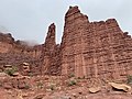
 South aspect of Cottontail Tower (left), Echo Tower to right
 -
 Cottontail, with Echo Tower to left
 -
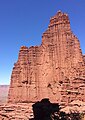
 South aspect
 -
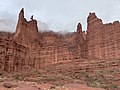 Kingfisher/Ancient Art to left, Cottontail to right
 -
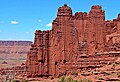
 Fisher Towers L→R: Kingfisher, Ancient Art, Cottontail, Titan.
 -
 South aspect of Cottontail Tower centered, Echo Tower to right, and Kingfisher fills in the V-gap between.
 -
 South aspect
 -
 Summit detail, south aspect.

.jpg)

.jpg)


References
edit- ^ a b c d e "Cottontail Tower - 5,980' UT". listsofjohn.com. Retrieved 2024-09-11.
- ^ a b "Cottontail Tower, Peakvisor.com". Retrieved 2024-09-11.
- ^ Contiguous US Steepness List, listsofjohn.com, Retrieved 2024-09-11.
- ^ a b Stewart M. Green, Best Easy Day Hikes Moab, Rowman & Littlefield, 2020, ISBN 9781493046898, p. 48.
- ^ Stewart M. Green, Rock Climbing Utah, Rowman & Littlefield, 2012, ISBN 9780762792849, p. 164.
- ^ Fisher Towers - Hittle Bottom Campground, sceen-it.com, Retrieved 2024-09-11.
- ^ First Ascent Timeline, deserttowersbook.com, Retrieved 2024-09-13.
- ^ Cameron Burns, Selected Climbs in the Desert Southwest: Colorado and Utah, The Mountaineers Books, 1999, ISBN 9780898866575, p. 72.
- ^ North America, United States, Utah, Utah Desert Climbing, Eric Bjørnstad, 1988, americanalpineclub.org.
- ^ The American Alpine Journal 1991, James Beyer, The Mountaineers Books, 1991, p. 172.
- ^ Fisher Towers, Eric Bjørnstad, American Alpine Journal, 1999, p. 230.
- ^ North America, United States, Utah, Fisher Towers, Cottontail Tower, Trick of the Tail, Paul Gagner, 2012, americanalpineclub.org.
- ^ Free Gaza Cottontail Tower, Mountain Project, Retrieved 2024-09-11.
- ^ Cottontail Tower, Line in the Sand, Utah, Fisher Towers, Scott Peterson, 2018, americanalpineclub.org.
- ^ Castle Valley Overview United States of America, Virtual 3D Geoscience, v3geo.com, Retrieved 2024-09-05.
- ^ GeoSights: Fisher Towers – The towering red rock sculptures of Grand County, Utah, Carl Ege, Utah Geological Survey, Retrieved 2024-09-12.
- ^ Peel, M. C.; Finlayson, B. L. & McMahon, T. A. (2007). "Updated world map of the Köppen−Geiger climate classification". Hydrol. Earth Syst. Sci. 11 (5): 1633–1644. Bibcode:2007HESS...11.1633P. doi:10.5194/hess-11-1633-2007. ISSN 1027-5606. S2CID 9654551.
External links
edit- Weather forecast: Fisher Towers
- Cottontail Tower Climbing: Mountainproject.com