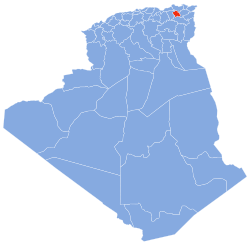
Constantine (Arabic: ولاية قسنطينة) is one of the 58 provinces (wilayas) of Algeria, whose capital is the city of the same name.
Constantine Province
ولاية قسنطينة ⴰⵝⴻⵣⴷⵓ ⵇⵙⴻⵏⵟⵉⵏⴰ | |
|---|---|
| Nickname: City Of Bridges | |
 Map of Algeria highlighting Constantine | |
 Map of the 6 districts of Constantine | |
| Coordinates: 36°21′N 6°36′E / 36.350°N 6.600°E | |
| Country | |
| Capital | Constantine |
| Government | |
| • PPA president | A.Chibane |
| Area | |
• Total | 2,187 km2 (844 sq mi) |
| Population (2019)[1] | |
• Total | 1,012,643 |
| • Density | 460/km2 (1,200/sq mi) |
| Demonym | Constantinian |
| Time zone | UTC+01 (CET) |
| Area Code | +213 (0) 31 |
| ISO 3166 code | DZ-25 |
| Districts | 6 |
| Municipalities | 12 |
History
editIn 1984 Mila Province was carved out of its territory.
Administrative divisions
editThe province is divided into 6 districts or daïra, which are subdivided into 12 communes or municipalities.[2]
List of districts
edit| District | Number of municipalities |
Municipalities | Area (km2) |
Population (hab.) |
|---|---|---|---|---|
| Constantine | 1 | Constantine | 231.63 | 462,374 |
| El Khroub | 3 | El Khroub • Aïn Smara • Ouled Rahmoune | 610.70 | 248,160 |
| Aïn Abid | 2 | Aïn Abid • Ibn Badis | 634.22 | 51,478 |
| Zighoud Youcef | 2 | Zighoud Youcef • Beni Hamiden | 367.97 | 48,432 |
| Hamma Bouziane | 2 | Hamma Bouziane • Didouche Mourad | 186.88 | 128,867 |
| Ibn Ziad | 2 | Ibn Ziad • Messaoud Boudjeriou | 257.37 | 30,623 |
References
edit- ^ Office National des Statistiques, Recensement General de la Population et de l’Habitat 2008 Archived July 24, 2008, at the Wayback Machine Preliminary results of the 2008 population census. Accessed on 2008-07-02.
- ^ "The official journal of People's Democratic Republic of Algeria" (PDF). SGG Algeria. Retrieved 2007-11-06.