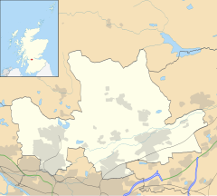
Cadder (Scottish Gaelic: Coille Dobhair) is a district of the town of Bishopbriggs, East Dunbartonshire, Scotland. It is located 7 km north of Glasgow city centre, 0.5 km south of the River Kelvin, and approximately 1.5 km north-east of Bishopbriggs town centre, sited on the route of the Forth and Clyde Canal. There is a Glasgow council housing scheme of a similar name, generally pronounced Cawder, in the district of Lambhill some 3 miles (5 km) to the south-west along the Canal, which was built in the early 1950s. Similarly, within Cadder, there is Cawder Golf Club, which also uses that original pronunciation.
Cadder
| |
|---|---|
 Cadder parish church erected in 1830[1] | |
Location within East Dunbartonshire | |
| OS grid reference | NS6172 |
| Council area | |
| Country | Scotland |
| Sovereign state | United Kingdom |
| Police | Scotland |
| Fire | Scottish |
| Ambulance | Scottish |
| UK Parliament | |
| Scottish Parliament | |
History
editIn antiquity, Cadder was the site of a Roman fort[6] on the route of the Antonine Wall.[7] Its neighbouring forts are Balmuildy to the west and Kirkintilloch to the east although there are intermediate fortlets at Wilderness Plantation to the west and Glasgow Bridge to the east.[8] The Second Legion may have been responsible for building the fort.[9] John Clarke of the Glasgow Archaeological Society excavated the remains in the 1930s.[10] Sir George Macdonald also wrote about the excavation of the site.[11] The site was destroyed by sand quarrying in the 1940s.[12] A sketch of the medieval motte made by Skinner still survives.[13] One find at Cadder was an oil lamp which is associated with the bath house of the fort.[14] Before the Reformation the lands of Cadder and the kirk belonged to the Bishops of Glasgow.[15][16] In the 18th century James Dunlop of Garnkirk being a wealthy landowner opposed Thomas Muir and the congregation at Cadder over who appointed their minister.[17][18][19] Cadder Parish Church was described in the 19th century as a neat modern Gothic church.[20] Cadder House was a property held by the Stirling family for generations.[21]
Cadder Today
editCadder has a large cemetery, is also the site of Strathkelvin Retail Park and Low Moss (HM Prison).[22]
Gallery
edit-
watchhouse and iron mortsafe at Cadder Parish Church
-
Cadder stables
-
Strathkelvin retail park
-
Cadder Road sign
References
edit- ^ Wilson, John Marius (1882). The gazetteer of Scotland. Edinburgh: W. & A.K. Johnston. p. 65. Retrieved 27 February 2018.
- ^ "RIB 2186. Distance Slab of the Second Legion". Roman Inscriptions of Britain. Retrieved 18 November 2017.
- ^ Macdonald, Sir George (1934). The Roman wall in Scotland, by Sir George Macdonald (2d ed., rev., enl., and in great part rewritten ed.). Oxford: The Clarendon press. pp. 369–372. Retrieved 11 October 2017.
- ^ "RIB 2209. Distance Slab of the Second Legion". Roman Inscriptions of Britain. Retrieved 18 November 2017.
- ^ Macdonald, Sir George (1934). The Roman wall in Scotland, by Sir George Macdonald (2d ed., rev., enl., and in great part rewritten ed.). Oxford: The Clarendon press. p. 404. Retrieved 11 October 2017.
- ^ "Cadder". CANMORE. Royal Commission on the Ancient and Historical Monuments of Scotland. Retrieved 18 November 2017.
- ^ "Antonine Wall: Wilderness Plantation - Easter Cawder - Cadder". CANMORE. Royal Commission on the Ancient and Historical Monuments of Scotland. Retrieved 18 November 2017.
- ^ "OS 25 inch map 1892-1949, with Bing opacity slider". National Library of Scotland. Ordnance Survey. Retrieved 12 October 2017.
- ^ "RIB 2188. Building inscription of the Second Legion Augusta". Roman Inscriptions of Britain. Retrieved 18 November 2017.
- ^ "The Journal of Roman Studies (Volume 24, Issue 1, 1934, pp. 104-105)". Cambridge University Press. Retrieved 29 April 2018.
- ^ Macdonald, Sir George (1934). The Roman wall in Scotland, by Sir George Macdonald (2d ed., rev., enl., and in great part rewritten ed.). Oxford: The Clarendon press. pp. 297–312. Retrieved 11 October 2017.
- ^ "CADDER: FORT" (PDF). Frontiers of the Roman Wall. Retrieved 25 November 2017.
- ^ Rohl, Darrell, Jesse. "More than a Roman Monument: A Place-centred Approach to the Long-term History and Archaeology of the Antonine Wall" (PDF). Durham Theses. Durham University. Available at Durham E-Theses Online ref: 9458. Retrieved 14 October 2017.
{{cite web}}: CS1 maint: multiple names: authors list (link) - ^ "Oil Lamp, Cadder". Retrieved 12 November 2017.
- ^ The new statistical account of Scotland. Vol. 6. Edinburgh and London: William Blackwood and Sons for the Society for the Benefit of the Sons and Daughters of the Clergy. 1845. pp. 298-315.
- ^ Brotchie, T.C.F. (1921). Some Sylvan Scenes near Glasgow. Glasgow: Aird & Coghill. pp. 35–38. Retrieved 3 December 2017.
- ^ Barclay, William (1791). The statistical account of Scotland. Vol. 8. Edinburgh: W. Creech. pp. 474-484.
- ^ "Thomas Muir - new evidence unearthed". Glasgow University. University news. 14 December 2016. Retrieved 24 February 2018.
- ^ Miller, Phil (14 December 2016). "Newly discovered papers unveil further details about the life of Thomas Muir, 'Father of Democracy'". The Herald. Retrieved 24 February 2018.
- ^ MacDonald, Hugh (1856). Rambles Round Glasgow (2nd ed.). Glasgow: Thomas Murray and Son. p. 376. Retrieved 30 November 2017.
- ^ Glasgow Digital Library "Cadder House"
- ^ Glasgow Guide Cadder Cemetery
