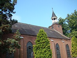
Breedenbroek is a Dutch village in the Achterhoek region in the Gelderland province, near the town Dinxperlo, Netherlands. It is located some 3 kilometres from the German border. Since the municipal rearrangement in 2005, Breedenbroek is a part of the municipality of Oude IJsselstreek.
Breedenbroek | |
|---|---|
 Roman Catholic church "Saints Peter and Paul" | |
| Coordinates: 51°52′25″N 6°28′16″E / 51.8736°N 6.4711°E | |
| Country | Netherlands |
| Province | Gelderland |
| Municipality | Oude IJsselstreek |
| Area | |
| • Total | 12.34 km2 (4.76 sq mi) |
| Elevation | 17 m (56 ft) |
| Population (2021)[1] | |
| • Total | 930 |
| • Density | 75/km2 (200/sq mi) |
| Time zone | UTC+1 (CET) |
| • Summer (DST) | UTC+2 (CEST) |
| Postal code | 7084[1] |
| Dialing code | 0315 |
It was first mentioned in 1386 as Bredenbroick, and means "wide swampy land".[3] The land was cultivated during the Middle Ages. The southern part became property of the Lords of Anholt and became known as Klein-Breedenbroek and the main settlement is often called Groot-Breedenbroek. In 1840, it was home to 283 people. The church dates from 1855.[4] In 2015, was decommissioned, and in 2021 the church was transformed into a cultural centre.[5] The grist mill "De Kempermolen" was built in 1882. In 1975, it was in poor condition and restored. In 2002–2003, it was repaired again.[6]
Gallery
edit-
't Migchelbrink
-
Transformation of the church into a cultural centre
-
House in Breedenbroek
References
edit- ^ a b c "Kerncijfers wijken en buurten 2021". Central Bureau of Statistics. Retrieved 24 March 2022.
two entries
- ^ "Postcodetool for 7084AA". Actueel Hoogtebestand Nederland (in Dutch). Het Waterschapshuis. Retrieved 24 March 2022.
- ^ "Breedenbroek - (geografische naam)". Etymologiebank (in Dutch). Retrieved 24 March 2022.
- ^ "Breedenbroek". Plaatsengids (in Dutch). Retrieved 24 March 2022.
- ^ "Cultuurkerk". Cultuurkerk de Toekomst (in Dutch). Retrieved 24 March 2022.
- ^ "De Kempermolen". Molen database (in Dutch). Retrieved 24 March 2022.
External links
editMedia related to Breedenbroek at Wikimedia Commons

