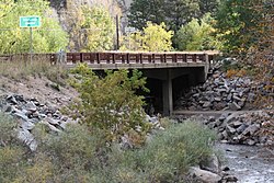
The Boulder Creek Bridge near Boulder, Colorado is a concrete slab and girder bridge which was built in 1953. It was listed on the National Register of Historic Places in 2003.[1]
Boulder Creek Bridge | |
 Arched support beam is visible in shadow under bridge deck | |
| Location | State Highway 119 at milepost 39.13 |
|---|---|
| Nearest city | Boulder, Colorado |
| Coordinates | 40°00′53″N 105°19′16″W / 40.01476°N 105.32100°W |
| Area | less than one acre |
| Built | 1953 |
| Architect | U.S. Bureau of Public Roads |
| Architectural style | Concrete slab and girder |
| MPS | Highway Bridges in Colorado MPS |
| NRHP reference No. | 03000103[1] |
| Added to NRHP | March 11, 2003 |
It brings Colorado State Highway 119 over Boulder Creek, and was under Federal rather than state management as the highway provides access from Boulder to the Roosevelt National Forest.[2]
It was designed by the U.S. Bureau of Public Roads.[3] It is 100 feet (30 m) in total length, and 39 feet (12 m) wide carrying a 34 feet (10 m)-wide roadbed. It consists of three spans, the main one being 48 feet (15 m) long. It has concrete abutments, wingwalls, and spill-through piers. Steel flex beams on the approach were a later addition.[2]
It was deemed technologically significant as one of the first concrete girder bridges in Colorado of a new type, having parabolically arched beams rather than flat ones, and supported by concrete spill through piers.[2]
References
edit- ^ a b "National Register Information System". National Register of Historic Places. National Park Service. November 2, 2013.
- ^ a b c Colorado Office of Archaeology and Historic Preservation; Clayton Fraser (May 21, 2002). "National Register of Historic Places Registration: Boulder Creek Bridge / CDOT No. D-15-AK: 5BL79". National Park Service. Retrieved October 10, 2021. With accompanying two photos from 2000
- ^ "Boulder Creek Bridge". History Colorado. Retrieved October 9, 2021.
External links
editMedia related to Boulder Creek Bridge (Colorado) at Wikimedia Commons
