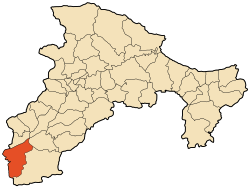
Boudjellil (Arabic: بوجليل; Kabyle: At Bujlil) is a commune in northern Algeria in the Béjaïa Province.
Boudjellil | |
|---|---|
 | |
 | |
| Coordinates: 36°20′N 4°21′E / 36.333°N 4.350°E | |
| Country | Algeria |
| Province | Bejaia |
| Time zone | UTC+1 (West Africa Time) |
Boudjellil is home to the community of Béni Mansour, where the regional Béni Mansour-Bejaïa line connects to the mainline Algiers-Skikda line.
Geography
editLocation
editBoudjellil is located in the Soummam Valley, in the southern Djurdjura at the extreme southwest of the Béjaïa Province. The commune borders the provinces of Bouira and Bordj Bou Arreridj, and is bounded by Tazmalt to the north, Aït Rizine and Ighil Ali to the east, Ighil Ali again to the south, Chorfa, Bouïra and Ath Mansour Taourirt (Bouira Province) to the west, and finally Ouled Sidi Brahim (Bordj Bou Arreridj) to the southwest. It is part of the Sahel-Djurdjura valley of Little Kabylie.
- Boudjellil is one of the three communes that make up the historic tribe of Ath Abbes along with Ait R'zine and Ighil Ali.
Relief, Geology, Hydrography
editBoudjellil is the largest commune in the Béjaïa Province with an area of 99.85 km2 (38.55 sq mi)
Climate
editWinters
editWinters were mild, with average temperatures around 12°C in January. Precipitation was moderate, totaling about 750 mm per year, with episodes of light rain more frequent in December and January.
Summers
editSummers were extremely hot, with temperatures reaching 41°C in July and August. The days were long and sunny. Nights, although cooler, were softened by a gentle breeze.
Springs and Autumns
editSprings and autumns offered pleasant climatic conditions, with spring temperatures ranging between 15°C and 25°C and autumn temperatures between 20°C and 30°C. Moderate rain prepared the region for the colder months.
In summary, Boudjellil experienced a varied climate in 2024, with very hot and dry summers, mild winters with some light rain, and pleasant springs and autumns.
Hamlets, Districts, and Villages
editThe commune of Boudjellil consists of 17 villages:
- Avalich
- Aftis
- Tigrine
- Hamda
- Ath wihdhan
- Thala lbir
- Tansawth
- Ath saida
- Ath mansour
- Ath Helassa
- Tawrirth
- Ath dacéne
- Talafsa
- Tighilt
- Ath alouane
- Metchike
- Azrou
- Boudjellil
Urbanism
edit.....
Toponymy
edit.....
History
editAccording to oral tradition, the inhabitants of Ait Vujlil in the commune lived in (Laazib N Ibujlilen) on the banks of Assif Asemmam. Threatened by a devastating epidemic, they had to abandon their lands and seek refuge mainly on the heights of Tinicwin (Agrur Nu Zimba) before finally settling in Azru, Abaliche, and Tighilt.
A-vujlil (pl. I-bujlilen) or the man who wears the tunic (ajlil), tends to identify, around the 19th century, as a landowner in an area between the Arch of Ath Aabbas and that of Ath Melikech, extending from Tamurt Ufella to the west, up to the limits of Ath Wihdan and the freshwater source (Thala M'ghisa) to the east.
Demographics
edit.....
Administration and Politics
editList of Mayors of Boudjellil
|
|---|
|
Economy
editThe commune has several companies, among them:
- UFMATP, specialized in the manufacture of public works and agricultural machinery.
- Platrière Boudjellil located in Thala lvir
Related Articles
edit
36°20′N 4°21′E / 36.333°N 4.350°E
