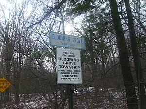
Blooming Grove Township is a township in Pike County, Pennsylvania, United States. The population was 5,421 at the 2020 census.[2]
Blooming Grove Township, Pennsylvania | |
|---|---|
 Signs along PA 739 entering Blooming Grove Township | |
 Location in Pike County and the state of Pennsylvania. | |
 Location of Pennsylvania in the United States | |
| Coordinates: 41°22′36″N 74°59′58″W / 41.37667°N 74.99944°W | |
| Country | United States |
| State | Pennsylvania |
| County | Pike |
| Government | |
| • Mayor | Carl " Jakie J Watash" Schick |
| Area | |
• Total | 76.99 sq mi (199.40 km2) |
| • Land | 74.83 sq mi (193.81 km2) |
| • Water | 2.16 sq mi (5.58 km2) |
| Elevation | 1,194 ft (364 m) |
| Population | |
• Total | 5,421 |
• Estimate (2021)[2] | 5,545 |
| • Density | 62.38/sq mi (24.09/km2) |
| Time zone | UTC-5 (EST) |
| • Summer (DST) | UTC-4 (EDT) |
| Area code | 570 |
| FIPS code | 42-103-07088 |
| Website | bloominggrovetownship |
History
editThe Lord House was added to the National Register of Historic Places in 1980.[3]
On September 12, 2014, outside the Troop R barracks of the Pennsylvania State Police in the township, a sniper opened fire on Pennsylvania State Police troopers with a .308-caliber rifle during a late-night shift change,[4] killing Corporal Bryon K. Dickson II, 38, and critically injuring trooper Alex Douglass.[5][6][7] Eric Matthew Frein was identified as the sole suspect of the ambush and was sought by federal and state authorities for the ambush, until his apprehension at 6 p.m. on Thursday, October 30, ending a seven-week search.[8]
Geography
editAccording to the United States Census Bureau, the township has a total area of 77.0 square miles (199 km2), of which 74.8 square miles (194 km2) is land and 2.2 square miles (5.7 km2) (2.86%) is water.
Demographics
edit| Census | Pop. | Note | %± |
|---|---|---|---|
| 1860 | 339 | — | |
| 1870 | 378 | 11.5% | |
| 1880 | 472 | 24.9% | |
| 1890 | 351 | −25.6% | |
| 1900 | 446 | 27.1% | |
| 1910 | 375 | −15.9% | |
| 1920 | 263 | −29.9% | |
| 1930 | 317 | 20.5% | |
| 1940 | 384 | 21.1% | |
| 1950 | 358 | −6.8% | |
| 1960 | 424 | 18.4% | |
| 1970 | 548 | 29.2% | |
| 1980 | 1,176 | 114.6% | |
| 1990 | 2,022 | 71.9% | |
| 2000 | 3,621 | 79.1% | |
| 2010 | 4,819 | 33.1% | |
| 2020 | 5,421 | 12.5% | |
| Pike County Demographics[9] | |||
As of the census[10] of 2010, there were 4,819 people, 1,834 households, and 1,348 families residing in the township. The population density was 64.4 inhabitants per square mile (24.9/km2). There were 3,971 housing units at an average density of 53.1 per square mile (20.5/km2). The racial makeup of the township was 91.8% White, 3.5% African American, 0.2% Native American, 1.1% Asian, 0.03% Pacific Islander, 1.7% from other races, and 1.8% from two or more races. Hispanic or Latino of any race were 5.4% of the population.
There were 1,834 households, out of which 24% had children under the age of 18 living with them, 61.1% were married couples living together, 7.4% had a female householder with no husband present, and 26.5% were non-families. 22.1% of all households were made up of individuals, and 12.1% had someone living alone who was 65 years of age or older. The average household size was 2.44 and the average family size was 2.85.
In the township the population was spread out, with 18.6% under the age of 18, 57.2% from 18 to 64, and 24.2% who were 65 years of age or older. The median age was 47.5 years.
The median income for a household in the township was $42,386, and the median income for a family was $46,250. Males had a median income of $31,941 versus $28,333 for females. The per capita income for the township was $20,920. About 6.4% of families and 8.6% of the population were below the poverty line, including 14.3% of those under age 18 and 4.6% of those age 65 or over.
Education
editThe school district is Wallenpaupack Area School District.[11]
References
edit- ^ "2016 U.S. Gazetteer Files". United States Census Bureau. Retrieved Aug 14, 2017.
- ^ a b c d Bureau, US Census. "City and Town Population Totals: 2020—2021". Census.gov. US Census Bureau. Retrieved August 6, 2022.
{{cite web}}:|last1=has generic name (help) - ^ "National Register Information System". National Register of Historic Places. National Park Service. July 9, 2010.
- ^ "Shots fired, police reported closing in on alleged trooper shooter Eric Frein". 20 September 2014.
- ^ Ambush suspect was former Northampton Community College student, The Express-Times, September 17, 2014.
- ^ Pennsylvania suspect in police killing belonged to 'military simulation unit', The Guardian, September 17, 2014.
- ^ Matt Assad and Peter Hall (2014-10-01). "No warning signs in ordinary life of trooper slaying suspect". Morning Call.
- ^ "Police Trooper Killed In Ambush To Be Laid To Rest". Huffington Post. September 18, 2014.
- ^ "Pike County, PA".
- ^ "U.S. Census website". United States Census Bureau. Retrieved 2011-05-14.
- ^ "2020 CENSUS - SCHOOL DISTRICT REFERENCE MAP: Pike County, PA" (PDF). U.S. Census Bureau. Retrieved 2024-07-18. - Text list
