Berc is a small village in the south of France. It is located in the department of Lozère, in the Massif Central, on the border with the department of Cantal, at an altitude of 1,101 metres (3,612 ft). In 1968 there were 144 inhabitants.
Berc | |
|---|---|
Part of Les Monts-Verts | |
 Église Sainte-Marie de Berc | |
Location of Berc  | |
 Berc  Berc | |
| Coordinates: 44°51′31″N 3°12′21″E / 44.85861°N 3.20583°E | |
| Country | France |
| Region | Occitania |
| Department | Lozère |
| Arrondissement | Mende |
| Commune | Les Monts-Verts |
| Population (1968) | 144 |
| Time zone | UTC+01:00 (CET) |
| • Summer (DST) | UTC+02:00 (CEST) |
| Postal code | 48200 |
| Elevation | 1,101 m (3,612 ft) |
| Website | lesmontsverts |
An independent commune until 1 January 1973, Berc now forms the new commune of Les Monts-Verts with the villages of Arcomie and Le Bacon.
History
editBerc was created in 1877 from the communes of Arcomie, La Fage-Saint-Julien and Termes.[1] On 1 January 1973, it merged with two communes, Arcomie and Le Bacon, to form the new commune named Les Monts-Verts.[1][2]
The town was known at the beginning of the twentieth century for its artisanal production of sabots.[3]
Local culture and heritage
editPlaces and monuments
edit- Église Sainte-Marie de Berc.[3]
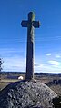
- Cross near the church of Sainte-Marie.
-
 Ancient cross.
 -
 Modern cross.


Personalities
edit- Pierre Veyron (1903-1970), Grand Prix motor racing driver, was born in Berc.[3][4] Bugatti Automobiles named one of its models, the Bugatti Veyron, after him.[3][5]
See also
editReferences
edit- ^ a b Des villages de Cassini aux communes d'aujourd'hui: Commune data sheet Berc, EHESS (in French).
- ^ "Commune supprimée de Berc" (in French). Insee. Retrieved 5 September 2024.
- ^ a b c d "Berc" (in French). Mairie Les Monts-Verts. Retrieved 23 January 2022.
- ^ "Pierre Veyron". historicracing.com. Retrieved 23 January 2022.
- ^ "Pierre Veyron". Bugatti Stories. bugatti.com. Bugatti Automobiles. 30 November 2011. Archived from the original on 2 June 2012. Retrieved 23 January 2022.
This Lozère geographical article is a stub. You can help Wikipedia by expanding it. |