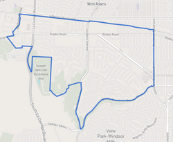
Baldwin Hills/Crenshaw is a neighborhood in the south region of the city of Los Angeles defined by the Mapping L.A. project of the Los Angeles Times in 2009.[1] The Times combines two city-designated neighborhoods: the upscale, principally home-owning Baldwin Hills residential district to the south and the more concentrated apartment area of the Crenshaw district to the north.
Baldwin Hills/Crenshaw | |
|---|---|
 Map of the Baldwin Hills/Crenshaw neighborhood of Los Angeles, as delineated by the Los Angeles Times | |
| Coordinates: 34°1′12.15″N 118°21′23.81″W / 34.0200417°N 118.3566139°W | |
| Country | |
| State | |
| City | Los Angeles |
| Area code | 323 |
History
editRancho La Cienega o Paso de la Tijera was a historic early-19th-century eastern hills Rancho land grant.[2][3]Baldwin Hills and other surrounding geography are named for the noted 19th-century horse racing and land development pioneer, Elias J. "Lucky" Baldwin
Geography
editDescription
editAccording to the 2009 Mapping L.A. project of the Los Angeles Times, Baldwin Hills/Crenshaw is bounded by Culver City, Jefferson Park, Ladera Heights, View Park-Windsor Hills and West Adams. Areas within it are Baldwin Village, Baldwin Vista, The Dons and Village Green.[1][4] The neighborhood limits, according to Mapping L.A, are Jefferson Boulevard on the north, Ballona Creek, Jefferson Boulevard and La Brea Avenue on the west, the Kenneth Hahn State Recreation Area and Stocker Street on the south and Crenshaw Boulevard on the east.[1]
A commercial corridor along Crenshaw Boulevard includes Baldwin Hills Crenshaw Plaza, Marlton Square and Crenshaw Boulevard.[1]
Neighborhoods
editBaldwin Hills/Crenshaw contains several neighborhoods:[4]
Demographics
editThis section needs to be updated. (June 2024) |
2000
editThe 2000 U.S census counted 30,123 residents in Baldwin Hills/Crenshaw and its area of 2.88 square miles gave it a population density of 10,446 people per square mile, about average for Los Angeles and the county as a whole.
2008
editIn 2008 the city estimated that 32,234 people lived there. The median age was 36, older than the city as a whole. The percentage of residents aged 65 and older was among the county's highest.[1]
The neighborhood was considered "moderately diverse"[5] in 2000, with 71.3% of residents being of black or African-American ancestry, 17.3% Latino, 4.7% Asian, 3.3% white and 3.4% of other backgrounds. The neighborhood had the fifth-highest concentration of black residents in the city.[1][6]
The average household size was 2.3 people, low compared to the city as a whole. Almost 32% of the 2,400 families living in Baldwin Hills-Crenshaw were headed by single parents,[1] the third-highest rate in the city, after Watts and Vermont Knolls.[7]
The median household income at $37,948 in 2008 dollars was low compared with both city and county populations. The percentage of households earning $20,000 or less a year was high for the county. The percentage of residents 25 and older with a high school education and some college was high for the county, Those with a college degree were about the same as the rest of the city and county.[1]
The large number of veterans, 2,272 or 10.2% of the population, was high for both the city and the county. The percentage of veterans who served during World War II or the Korean War was among the county's highest.[1]
Only 16.6% of the residents were foreign born, a low figure for both the city and the county. Mexico (31%) and El Salvador (16.8%) were the most common foreign places of birth.[1]
Parks and recreation
editThere are four parks in Baldwin Hills, including Baldwin Hills Scenic Overlook State Park.
Government
editThe Los Angeles Fire Department Station 94 serves the neighborhood.
Education
editLos Angeles Unified School District operates Susan Miller Dorsey High School, Crenshaw High School, and numerous other public schools in the area.
Notable people
editNumerous famous people, including Meghan Markle, Duchess of Sussex, Darryl Strawberry and Tiffany Haddish, reside in either Baldwin Hills or the Crenshaw District.
See also
editReferences
edit- ^ a b c d e f g h i j [1] "Baldwin Hills/Crenshaw," Mapping LA, Los Angeles Times
- ^ "Rancho La Cienega O'Paso de La Tijera". Laokay.com. Retrieved August 22, 2010.
- ^ U.S. Geological Survey Geographic Names Information System: Rancho La Cienega o Paso de la Tijera
- ^ a b [2] "South L.A.," Mapping L.A., Los Angeles Times
- ^ [3] Diversity "measures the probability that any two residents, chosen at random, would be of different ethnicities. If all residents are of the same ethnic group it's zero. If half are from one group and half from another it's .50." —Los Angeles Times
- ^ [4] "Black," Mapping L.A., Los Angeles Times
- ^ "Single Parents," Mapping L.A., Los Angeles Times
