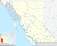
Baldonnel (population ~142) is a town in the Peace River District of British Columbia, Canada, near Fort St. John. It is at an elevation of 680 meters (2,230 ft). The community contains a K-6 school and used to contain a post office.
Location of Baldonnel in British Columbia
Name
editThe community gives the name to the gas bearing Baldonnel Formation.
Climate
edit| Climate data for Baldonnel | |||||||||||||
|---|---|---|---|---|---|---|---|---|---|---|---|---|---|
| Month | Jan | Feb | Mar | Apr | May | Jun | Jul | Aug | Sep | Oct | Nov | Dec | Year |
| Record high °C (°F) | 13.3 (55.9) |
14.4 (57.9) |
18.9 (66.0) |
29.4 (84.9) |
31.7 (89.1) |
32.2 (90.0) |
40.6 (105.1) |
34.5 (94.1) |
32.8 (91.0) |
27.2 (81.0) |
18.3 (64.9) |
12.2 (54.0) |
40.6 (105.1) |
| Mean daily maximum °C (°F) | −7.3 (18.9) |
−5.3 (22.5) |
1.3 (34.3) |
9.8 (49.6) |
16.3 (61.3) |
19.7 (67.5) |
21.9 (71.4) |
20.8 (69.4) |
14.8 (58.6) |
7.8 (46.0) |
−4.6 (23.7) |
−8.2 (17.2) |
7.2 (45.0) |
| Daily mean °C (°F) | −11.4 (11.5) |
−9.9 (14.2) |
−3.7 (25.3) |
4.2 (39.6) |
10.2 (50.4) |
13.9 (57.0) |
15.9 (60.6) |
14.8 (58.6) |
9.5 (49.1) |
3.5 (38.3) |
−8.4 (16.9) |
−12.1 (10.2) |
2.2 (36.0) |
| Mean daily minimum °C (°F) | −15.5 (4.1) |
−14.4 (6.1) |
−8.6 (16.5) |
−1.4 (29.5) |
4.0 (39.2) |
8.0 (46.4) |
9.8 (49.6) |
8.8 (47.8) |
4.3 (39.7) |
−0.8 (30.6) |
−12.1 (10.2) |
−15.7 (3.7) |
−2.8 (27.0) |
| Record low °C (°F) | −48.9 (−56.0) |
−42.8 (−45.0) |
−37.2 (−35.0) |
−32.2 (−26.0) |
−10.6 (12.9) |
−2.8 (27.0) |
1.1 (34.0) |
−2.8 (27.0) |
−13.9 (7.0) |
−26.5 (−15.7) |
−40.0 (−40.0) |
−47.8 (−54.0) |
−48.9 (−56.0) |
| Average precipitation mm (inches) | 25.9 (1.02) |
18.5 (0.73) |
17.7 (0.70) |
22.4 (0.88) |
39.7 (1.56) |
70.0 (2.76) |
75.3 (2.96) |
51.3 (2.02) |
43.8 (1.72) |
32.0 (1.26) |
28.1 (1.11) |
25.2 (0.99) |
449.7 (17.70) |
| Average rainfall mm (inches) | 0.3 (0.01) |
0.3 (0.01) |
0.3 (0.01) |
14.2 (0.56) |
36.4 (1.43) |
70.0 (2.76) |
75.3 (2.96) |
51.3 (2.02) |
42.7 (1.68) |
19.1 (0.75) |
2.6 (0.10) |
1.4 (0.06) |
313.9 (12.36) |
| Average snowfall cm (inches) | 25.5 (10.0) |
18.2 (7.2) |
17.4 (6.9) |
8.2 (3.2) |
3.3 (1.3) |
0.0 (0.0) |
0.0 (0.0) |
0.0 (0.0) |
1.0 (0.4) |
12.9 (5.1) |
25.5 (10.0) |
23.8 (9.4) |
135.8 (53.5) |
| Average precipitation days (≥ 0.2 mm) | 9.8 | 9.5 | 7.5 | 8.0 | 10.7 | 12.1 | 13.0 | 12.2 | 11.3 | 10.5 | 11.8 | 10.0 | 126.4 |
| Average rainy days (≥ 0.2 mm) | 0.4 | 0.5 | 0.4 | 5.8 | 10.7 | 12.1 | 13.0 | 12.2 | 11.2 | 6.9 | 1.7 | 0.5 | 75.2 |
| Average snowy days (≥ 0.2 cm) | 9.5 | 9.0 | 7.3 | 3.8 | 0.6 | 0.0 | 0.0 | 0.0 | 0.6 | 4.9 | 10.5 | 9.6 | 55.7 |
| Source: [1] | |||||||||||||
References
edit- ^ "Calculation Information for 1981 to 2010 Canadian Normals Data". Environment Canada. Archived from the original on 14 June 2013. Retrieved 9 July 2013.
56°13′02″N 120°41′24″W / 56.21722°N 120.69000°W
