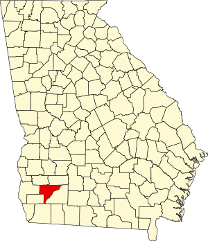
Baker County is a county in Georgia. As of the 2020 census, the population was 2,876, making it the fifth-least populous county in Georgia.[1] The county seat and only city is Newton.[2] The county was created December 12, 1825, from the eastern portion of Early County by an act of the Georgia General Assembly and is named for Colonel John Baker, a hero of the American Revolutionary War.[3]
Baker County | |
|---|---|
 | |
 Location within the U.S. state of Georgia | |
 Georgia's location within the U.S. | |
| Coordinates: 31°20′N 84°27′W / 31.33°N 84.45°W | |
| Country | |
| State | |
| Founded | December 12, 1825 |
| Named for | John Baker |
| Seat | Newton |
| Largest city | Newton |
| Area | |
• Total | 349 sq mi (900 km2) |
| • Land | 342 sq mi (890 km2) |
| • Water | 7.2 sq mi (19 km2) 2.1% |
| Population (2020) | |
• Total | 2,876 |
| • Density | 8/sq mi (3/km2) |
| Time zone | UTC−5 (Eastern) |
| • Summer (DST) | UTC−4 (EDT) |
| Congressional district | 2nd |
Baker County is included in the Albany, GA metropolitan statistical area.
The Baker County Courthouse (Georgia) is listed on the National Register of Historic Places. Three other properties in Newton are also listed on the register: Notchaway Baptist Church and Cemetery, Pine Bloom Plantation, and Tarver Plantation.
Geography
editAccording to the U.S. Census Bureau, the county has a total area of 349 square miles (900 km2), of which 342 square miles (890 km2) is land and 7.2 square miles (19 km2) (2.1%) is water.[4]
The eastern half of Baker County is located in the Lower Flint River sub-basin of the ACF River Basin (Apalachicola-Chattahoochee-Flint River Basin). The western half of the county is located in the Ichawaynochaway Creek sub-basin of the same ACF River Basin.[5]
Major highways
editAdjacent counties
edit- Dougherty County, Georgia - northeast
- Mitchell County, Georgia - east
- Decatur County, Georgia - southwest
- Early County, Georgia - west
- Miller County, Georgia - west
- Calhoun County, Georgia - northwest
Communities
editCity
editUnincorporated communities
editGhost towns
editDemographics
edit| Census | Pop. | Note | %± |
|---|---|---|---|
| 1830 | 1,253 | — | |
| 1840 | 4,226 | 237.3% | |
| 1850 | 8,120 | 92.1% | |
| 1860 | 4,985 | −38.6% | |
| 1870 | 6,843 | 37.3% | |
| 1880 | 7,307 | 6.8% | |
| 1890 | 6,144 | −15.9% | |
| 1900 | 6,704 | 9.1% | |
| 1910 | 7,973 | 18.9% | |
| 1920 | 8,298 | 4.1% | |
| 1930 | 7,818 | −5.8% | |
| 1940 | 7,344 | −6.1% | |
| 1950 | 5,952 | −19.0% | |
| 1960 | 4,543 | −23.7% | |
| 1970 | 3,875 | −14.7% | |
| 1980 | 3,808 | −1.7% | |
| 1990 | 3,615 | −5.1% | |
| 2000 | 4,074 | 12.7% | |
| 2010 | 3,451 | −15.3% | |
| 2020 | 2,876 | −16.7% | |
| 2023 (est.) | 2,743 | [7] | −4.6% |
| U.S. Decennial Census[8] 1790-1880[9]1890-1910[10] 1920-1930[11] 1930-1940[12] 1940-1950[13] 1960-1980[14] 1980-2000[15] 2010[16] 2020[17] | |||
| Race / Ethnicity (NH = Non-Hispanic) | Pop 2000[18] | Pop 2010[19] | Pop 2020[17] | % 2000 | % 2010 | % 2020 |
|---|---|---|---|---|---|---|
| White alone (NH) | 1,889 | 1,642 | 1,514 | 46.37% | 47.58% | 52.64% |
| Black or African American alone (NH) | 2,038 | 1,600 | 1,128 | 50.02% | 46.36% | 39.22% |
| Native American or Alaska Native alone (NH) | 9 | 9 | 1 | 0.22% | 0.26% | 0.03% |
| Asian alone (NH) | 0 | 24 | 18 | 0.00% | 0.70% | 0.63% |
| Pacific Islander alone (NH) | 1 | 2 | 0 | 0.02% | 0.06% | 0.00% |
| Other race alone (NH) | 2 | 1 | 2 | 0.05% | 0.03% | 0.07% |
| Mixed race or Multiracial (NH) | 24 | 28 | 70 | 0.59% | 0.81% | 2.43% |
| Hispanic or Latino (any race) | 111 | 145 | 143 | 2.72% | 4.20% | 4.97% |
| Total | 4,074 | 3,451 | 2,876 | 100.00% | 100.00% | 100.00% |
As of the 2020 United States Census, there were 2,876 people, 1,425 households, and 788 families residing in the county.
Education
editBaker County School System operates public schools.[20]
Politics
editLike most Deep South counties, Baker County is historically Democratic. Starting in 1964, the county began to see a realignment, with Barry Goldwater and Richard Nixon carrying it in 1964 and 1972, and American Independent candidate George Wallace winning the county in 1968 as a third-party candidate. In 1956, Adlai Stevenson received over 96 percent of the county's vote.[21] The county voted Democratic consistently from 1976 until 2012, but by closer margins than in 1956, and the county shifted more to the right throughout the early 2000s. In 2008 Barack Obama won with just 50.1 percent to John McCain's 49.1 percent,[22] while Donald Trump won the county by almost ten percent in 2016, despite declining on Mitt Romney’s performance statewide. Brian Kemp repeated this feat by double digits in the 2018 gubernatorial race, and in 2020, Trump won Baker County by nearly sixteen percentage points.[23]
| Year | Republican | Democratic | Third party(ies) | |||
|---|---|---|---|---|---|---|
| No. | % | No. | % | No. | % | |
| 2024 | 883 | 59.82% | 590 | 39.97% | 3 | 0.20% |
| 2020 | 897 | 57.68% | 652 | 41.93% | 6 | 0.39% |
| 2016 | 775 | 53.82% | 650 | 45.14% | 15 | 1.04% |
| 2012 | 785 | 49.34% | 794 | 49.91% | 12 | 0.75% |
| 2008 | 828 | 49.02% | 846 | 50.09% | 15 | 0.89% |
| 2004 | 821 | 46.52% | 936 | 53.03% | 8 | 0.45% |
| 2000 | 615 | 40.49% | 893 | 58.79% | 11 | 0.72% |
| 1996 | 408 | 27.66% | 955 | 64.75% | 112 | 7.59% |
| 1992 | 391 | 26.63% | 864 | 58.86% | 213 | 14.51% |
| 1988 | 629 | 46.66% | 707 | 52.45% | 12 | 0.89% |
| 1984 | 675 | 49.41% | 691 | 50.59% | 0 | 0.00% |
| 1980 | 510 | 32.61% | 1,035 | 66.18% | 19 | 1.21% |
| 1976 | 305 | 20.79% | 1,162 | 79.21% | 0 | 0.00% |
| 1972 | 965 | 73.66% | 345 | 26.34% | 0 | 0.00% |
| 1968 | 99 | 5.78% | 548 | 31.97% | 1,067 | 62.25% |
| 1964 | 914 | 60.33% | 600 | 39.60% | 1 | 0.07% |
| 1960 | 66 | 8.40% | 720 | 91.60% | 0 | 0.00% |
| 1956 | 32 | 3.93% | 783 | 96.07% | 0 | 0.00% |
| 1952 | 155 | 13.36% | 1,005 | 86.64% | 0 | 0.00% |
| 1948 | 7 | 2.47% | 218 | 77.03% | 58 | 20.49% |
| 1944 | 31 | 6.09% | 478 | 93.91% | 0 | 0.00% |
| 1940 | 30 | 5.10% | 557 | 94.73% | 1 | 0.17% |
| 1936 | 13 | 2.12% | 599 | 97.72% | 1 | 0.16% |
| 1932 | 2 | 0.31% | 647 | 99.23% | 3 | 0.46% |
| 1928 | 99 | 17.65% | 462 | 82.35% | 0 | 0.00% |
| 1924 | 21 | 7.69% | 245 | 89.74% | 7 | 2.56% |
| 1920 | 80 | 36.20% | 141 | 63.80% | 0 | 0.00% |
| 1916 | 94 | 17.77% | 435 | 82.23% | 0 | 0.00% |
| 1912 | 5 | 2.66% | 183 | 97.34% | 0 | 0.00% |
See also
editReferences
edit- ^ "Census - Geography Profile: Baker County, Georgia". United States Census Bureau. Retrieved December 26, 2022.
- ^ "Find a County". National Association of Counties. Archived from the original on May 31, 2011. Retrieved June 7, 2011.
- ^ Candler, Allen Daniel; Evans, Clement Anselm (1906). Georgia: Comprising Sketches of Counties, Towns, Events, Institutions, and Persons. State historical association. p. 114.
- ^ "US Gazetteer files: 2010, 2000, and 1990". United States Census Bureau. February 12, 2011. Retrieved April 23, 2011.
- ^ "Georgia Soil and Water Conservation Commission Interactive Mapping Experience". Georgia Soil and Water Conservation Commission. Archived from the original on October 3, 2018. Retrieved November 24, 2015.
- ^ Baker County Historical Society (1991). The History of Baker County. Newton, Baker County, Georgia, USA: Baker County Historical Society. pp. 54–69. LCCN 92080765.
- ^ "Annual Estimates of the Resident Population for Counties: April 1, 2020 to July 1, 2023". United States Census Bureau. Retrieved March 31, 2024.
- ^ "Decennial Census of Population and Housing by Decades". US Census Bureau.
- ^ "1880 Census Population by Counties 1790-1800" (PDF). US Census Bureau. 1880.
- ^ "1910 Census of Population - Georgia" (PDF). US Census Bureau. 1910.
- ^ "1930 Census of Population - Georgia" (PDF). US Census Bureau. 1930.
- ^ "1940 Census of Population - Georgia" (PDF). US Census Bureau. 1940.
- ^ "1950 Census of Population - Georgia -" (PDF). US Census Bureau. 1950.
- ^ "1980 Census of Population - Number of Inhabitants - Georgia" (PDF). US Census Bureau. 1980.
- ^ "2000 Census of Population - Population and Housing Unit Counts - Georgia" (PDF). US Census Bureau. 2000.
- ^ "State & County QuickFacts". United States Census Bureau. Archived from the original on June 7, 2011. Retrieved June 17, 2014.
- ^ a b "P2 Hispanic or Latino, and Not Hispanic or Latino by Race – 2020: DEC Redistricting Data (PL 94-171) - Baker County, Georgia". United States Census Bureau.
- ^ "P004: Hispanic or Latino, and Not Hispanic or Latino by Race – 2000: DEC Summary File 1 – Baker County, Georgia". United States Census Bureau.
- ^ "P2 Hispanic or Latino, and Not Hispanic or Latino by Race – 2010: DEC Redistricting Data (PL 94-171) – Baker County, Georgia". United States Census Bureau.
- ^ Baker County School System Retrieved February 23, 2011.
- ^ David Leip's Presidential Atlas: 1956 statistics
- ^ The New York Times Electoral Map (Zoom in on Georgia)
- ^ "Pivot Counties in Georgia", ballotpedia.org, retrieved September 23, 2024
- ^ Leip, David. "Dave Leip's Atlas of U.S. Presidential Elections". uselectionatlas.org. Retrieved March 18, 2018.
Further reading
edit- John P. Campbell, ed. (1854). "Georgia: Baker County". Southern Business Directory. Charleston, SC: Press of Walker & James – via HathiTrust.
- Adiel Sherwood (1860), "Baker County", A Gazetteer of Georgia (4th ed.), Georgia – via HathiTrust
{{citation}}: CS1 maint: location missing publisher (link) - Allen D. Candler; Clement A. Evans, eds. (1906). "Baker County". Georgia: Comprising Sketches of Counties, Towns, Events, Institutions, and Persons Arranged in Cyclopedic Form. Vol. 1. Atlanta: State Historical Association. p. 114 – via HathiTrust.
External links
edit- Baker County Sheriff's Office
- Baker County historical marker
- "Baker County", New Georgia Encyclopedia, Georgia Humanities Council
- Digital Public Library of America. Assorted items related to Baker County
