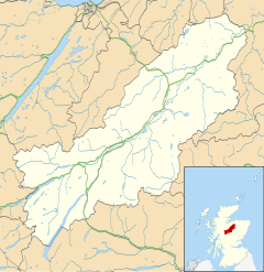
Avielochan (Scottish Gaelic: Aghaidh an Lochain) is a hamlet in the historical county of Inverness-shire, within the Highland council area of Scotland. It is located north of Aviemore, on the A9 road. The area is noted for its prehistoric cairn.
Avielochan
| |
|---|---|
 | |
Location within the Badenoch and Strathspey area | |
| OS grid reference | NH905165 |
| Council area | |
| Country | Scotland |
| Sovereign state | United Kingdom |
| Police | Scotland |
| Fire | Scottish |
| Ambulance | Scottish |
| UK Parliament | |
| Scottish Parliament | |
Geography and wildlife
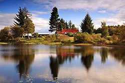
editAvielochan is located in Strathspey[1] in central, northern Scotland, within the Cairngorms National Park. The village is located south of Kinveachy and north of Granish.[2] The settlement takes its name from the body of water Avie Lochan[3] (meaning "the small lake of Avie) archaically named Loch-na- mhoon, measuring about 90 yards long, and 50 across.[4] Prior to the great floods in 1829, there was a floating island on the loch measuring about 30 yards across.[4] It attracts ospreys during the spring and summer months and goldeneye, coot and Slavonian grebe, amongst others.[5] Red squirrel, red deer, roe deer, black grouse and capercaillie inhabit the area.[5]
Buildings
editAvelochan Farm lets out self-catering cottages during the warmer months of the year to tourists.[5] The farm itself covers an area of 270 hectares, with arable fields, rough grazing and woodland.[6] At certain times in the year it has around 80 cattle and some 60 Cheviot ewes which are crossed with a Suffolk tup before they are sold in early autumn.[6] One building of note is Clach Mhor (meaning 'big stone' in Gaelic) which is located on the edge of the village.[7]
Chamber tomb
editThe area is noted for its prehistoric chamber tomb stones which are said to be particularly old by some sources, although they have not been dated reliably.[8][9] The site contains a cairn which is very circular in shape except for a slight flattening at the entrance, where part of a lignite amulet has been unearthed.[9][10] The tumulus is about 40 feet in diameter.[1]
The cairn is said to be "aligned" with Glen Einich, and has views of the Cairngorm Mountains.[11]
References
edit- ^ a b Thompson, Francis (1979). Portrait of the Spey. Hale. p. 93. ISBN 978-0-7091-7468-4. Retrieved 20 February 2011.
- ^ Google Maps (Map). Google. Retrieved 20 February 2011.
- ^ "Get -a-Map". Ordnance Survey. Retrieved 21 Feb 2011.
- ^ a b The Topographical, Statistical, and Historical Gazetteer of Scotland: A-H. A. Fullarton. 1842. p. 82. Retrieved 20 February 2011.
- ^ a b c "Welcome". Avielochan Cottages. Retrieved 20 February 2011.
- ^ a b "The Farm". Avielochan Cottages. Archived from the original on 16 February 2011. Retrieved 20 February 2011.
- ^ Royal Institute of British Architects (1 January 1994). RIBA journal. RIBA Journals. p. 46. Retrieved 20 February 2011.
- ^ Prehistoric Society (London; England); University of Cambridge. University Museum of Archaeology and Ethnology (1948). Proceedings of the Prehistoric Society for ... University Museum of Archaeology and Ethnology. p. 176. Retrieved 20 February 2011.
- ^ a b The Prehistory of Scotland. Taylor & Francis. p. 52. Retrieved 20 February 2011.
- ^ Henshall, Audrey S.; Ritchie, James Neil Graham (2001). The chambered cairns of the central Highlands: an inventory of the structures and their contents. Edinburgh University Press. p. 84. ISBN 978-0-7486-0643-6. Retrieved 20 February 2011.
- ^ Bradley, Richard; Batey, Colleen E. (1 July 2000). The good stones: a new investigation of the Clava Cairns. Society Antiquaries Scotland. p. 182. ISBN 978-0-903903-17-2. Retrieved 20 February 2011.
