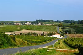
Arthenac (French pronunciation: [aʁtənak]) is a commune in the Charente-Maritime department in the Nouvelle-Aquitaine region of south-western France.
Arthenac | |
|---|---|
 A general view of Arthenac | |
| Coordinates: 45°30′57″N 0°18′48″W / 45.5158°N 0.3133°W | |
| Country | France |
| Region | Nouvelle-Aquitaine |
| Department | Charente-Maritime |
| Arrondissement | Jonzac |
| Canton | Jonzac |
| Intercommunality | CC Haute Saintonge |
| Government | |
| • Mayor (2020–2026) | Bruno Chainier[1] |
| Area 1 | 12.66 km2 (4.89 sq mi) |
| Population (2021)[2] | 345 |
| • Density | 27/km2 (71/sq mi) |
| Time zone | UTC+01:00 (CET) |
| • Summer (DST) | UTC+02:00 (CEST) |
| INSEE/Postal code | 17020 /17520 |
| Elevation | 43–111 m (141–364 ft) (avg. 72 m or 236 ft) |
| 1 French Land Register data, which excludes lakes, ponds, glaciers > 1 km2 (0.386 sq mi or 247 acres) and river estuaries. | |
The commune has been awarded three flowers by the National Council of Towns and Villages in Bloom in the Competition of cities and villages in Bloom.[3]
Geography
editArthenac is located in the south of Charente-Maritime in the former province of Saintonge some 24 km south-east of Pons, 16 km north-east of Jonzac, and immediately south-west of Archiac. Access to the commune is by the D699 road from Archiac in the north-west passing through the village and continuing south-west to Réaux. There is also the D251 road from Sainte-Lheurine in the north-west passing through south of the village to Saint-Eugène in the south-east. The D149 comes from the D700 in the north passing through the village then south to Allas-Champagne. The commune is mostly farmland with two large forests south of the village.[4]
Neighbouring communes and villages
editHistory
editUnder the Ancien Régime Arthenac was independent but was merged with Archiac in 1789. The commune regained its independent status on 13 October 1831.
Administration
editList of Successive Mayors[5]
| From | To | Name | Party |
|---|---|---|---|
| 2001 | 2020 | Chantal Guimberteau | DVD |
| 2020 | 2026 | Bruno Chainier |
Demography
editThe inhabitants of the commune are known as Arthenacais or Arthenacaises in French.[6]
|
| ||||||||||||||||||||||||||||||||||||||||||||||||||||||||||||||||||||||||||||||||||||||||||||||||||||||
| Source: EHESS[7] and INSEE[8] | |||||||||||||||||||||||||||||||||||||||||||||||||||||||||||||||||||||||||||||||||||||||||||||||||||||||
Distribution of Age Groups
editThe population of the town is younger than the departmental average.
Percentage Distribution of Age Groups in Arthenac and Charente-Maritime Department in 2017
| Arthenac | Charente-Maritime | |||
|---|---|---|---|---|
| Age Range | Men | Women | Men | Women |
| 0 to 14 Years | 20.5 | 19.6 | 16.3 | 14.3 |
| 15 to 29 Years | 14.5 | 10.1 | 15.4 | 13.1 |
| 30 to 44 Years | 21.7 | 19.0 | 16.7 | 16.1 |
| 45 to 59 Years | 19.9 | 18.4 | 20.2 | 19.9 |
| 60 to 74 Years | 14.5 | 19.0 | 21.1 | 22.0 |
| 75 to 89 Years | 9.0 | 11.7 | 9.4 | 12.3 |
| 90 Years+ | 0.0 | 2.2 | 1.0 | 2.4 |
Sites and monuments
edit- The Church of Saint Martin (12th century) at Arthenac has had its central window restored. It is registered as a historical monument.[10]
See also
editReferences
edit- ^ "Répertoire national des élus: les maires". data.gouv.fr, Plateforme ouverte des données publiques françaises (in French). 2 December 2020.
- ^ "Populations légales 2021" (in French). The National Institute of Statistics and Economic Studies. 28 December 2023.
- ^ Arthenac in the Competition for Towns and Villages in Bloom Archived December 10, 2014, at the Wayback Machine (in French)
- ^ Google Maps
- ^ List of Mayors of France (in French)
- ^ Le nom des habitants du 17 - Charente-Maritime, habitants.fr
- ^ Des villages de Cassini aux communes d'aujourd'hui: Commune data sheet Arthenac, EHESS (in French).
- ^ a b Évolution et structure de la population en 2017: Commune d'Arthenac (17020)
- ^ Évolution et structure de la population en 2017: Département de la Charente-Maritime (17)
- ^ Base Mérimée: Church of Saint Martin, Ministère français de la Culture. (in French)


