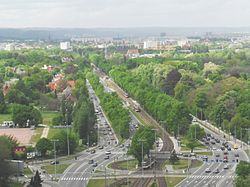
Aniołki (Polish pronunciation: [aɲɔwkʲ], Kashubian: Janiółczi; lit. Little Angels) is one of the quarters of Gdańsk in Poland.
Aniołki | |
|---|---|
 View on Aniołki from Victory Alley | |
 | |
| Coordinates: 54°21′42″N 18°37′54″E / 54.36169°N 18.63173°E | |
| Country | |
| Voivodeship | |
| City | |
| Government | |
| • Governor | Monika Mazurowska |
| Area | |
| • Total | 2.31 km2 (0.89 sq mi) |
| Population (2020) | |
| • Total | 4,418[1] |
| • Density | 1,914/km2 (4,960/sq mi) |
Location
editAniołki is located in the centre of the city, mainly around Victory Alley. It borders Wrzeszcz Górny and Wrzeszcz Dolny in the north, Młyniska in the east, Śródmieście and Siedlce in the south, and Suchanino in the west.
History
editThe name of Aniołki comes from the Church of St. Michael and All the Heaven's Angels, where an old tank currently stands as a statue. The church's ruins were uncovered in 2021.[2]
Near the quarter of Brama Oliwska, a railway station (built in 1870) functioned that was the main connection to most of Pomerania. Around 1900, the Gdańsk Główny railway station was built and the station was destroyed.[3]
In 1896, the ruins of a cemetery were removed and replaced with Steffens Park, named after Otto Steffens.[4]
In 1946, the ruins of the Church of St. Michael and All the Heaven's Angels were replaced with a T-34 tank.[5]
References
edit- ^ "Podział administracyjny Gdańska". bip.gdansk.pl. 31 December 2020. Retrieved 8 August 2021.
- ^ Oleksy, Ewelina (16 March 2021). "Relikty kościoła i cmentarza na działce, gdzie wycięto drzewa". trojmiasto.pl. Retrieved 31 July 2021.
- ^ Zoppoter. "Gdzie był dworzec Brama Oliwska (Am Olivaer Tor)?". Akademia Rzygacy. Archived from the original on 10 September 2012. Retrieved 31 July 2021.
- ^ "Park Steffensów". Zarząd Dróg i Zieleni w Gdańsku. Archived from the original on 2012-01-28. Retrieved 31 July 2021.
- ^ Gotard, Marek (7 July 2009). "Pancerna historia Trójmiasta, czyli Miazga z czołgiem". trojmiasto.pl. Retrieved 31 July 2021.
External links
edit