Nickname: Rock City | |
|---|---|
| Geography | |
| Location | Caribbean Sea |
| Coordinates | 18°20′N 64°55′W / 18.333°N 64.917°W |
| Archipelago | Virgin Islands, Leeward Islands |
| Area | 32.14 sq mi (83.2 km2) |
| Highest elevation | 1,555 ft (474 m) |
| Administration | |
| Demographics | |
| Demonym | Saint Thomian |
| Population | 51,634 |
| Pop. density | 638.17/km2 (1652.85/sq mi) |

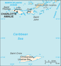
Saint Thomas (Spanish: Santo Tomás; Dutch: Sint-Thomas; Danish: Sankt Thomas) is one of the Virgin Islands in the Caribbean Sea and, together with St. John, Water Island and St. Croix, form a county and constituent district of the United States Virgin Islands (USVI), an unincorporated territory of the United States. Located on the island is the territorial capital and port of Charlotte Amalie. As of the 2010 census, the population of Saint Thomas was 51,634[2] about 48.5% of the US Virgin Islands total. The district has a land area of 31.24 square miles (80.9 km2).
- ^ "Where is the U.S. Virgin Islands: Geography". vinow.com. Retrieved April 8, 2017.
- ^ Kossler, Bill (August 24, 2011). "USVI Population Down Since 2000". stthomassource.com. V.I. Source Publications. Retrieved January 11, 2017.
