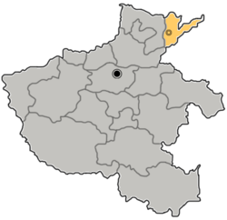
Taiqian County (Chinese: 台前县; pinyin: Táiqián Xiàn) is a county in the northeast of Henan province, China, bordering Henan's Fan County to the southwest and Shandong province in all other directions. It is under the administration of the prefecture-level city of Puyang, and generally lies on the north bank of the Yellow River.
Taiqian County
台前县 | |
|---|---|
 Taiqian in Puyang | |
 Puyang in Henan | |
| Country | People's Republic of China |
| Province | Henan |
| Prefecture-level city | Puyang |
| Area | |
• Total | 454 km2 (175 sq mi) |
| Population (2019) | |
• Total | 330,400[1] |
| Time zone | UTC+8 (China Standard) |
| Postal code | 457600 |
Administrative divisions
editAs 2012, this county is divided to 2 towns and 7 townships.[2]
- Towns
- Chengguan (城关镇)
- Houmiao (侯庙镇)
- Townships
|
|
Climate
edit| Climate data for Taiqian (1991–2020 normals, extremes 1981–2010) | |||||||||||||
|---|---|---|---|---|---|---|---|---|---|---|---|---|---|
| Month | Jan | Feb | Mar | Apr | May | Jun | Jul | Aug | Sep | Oct | Nov | Dec | Year |
| Record high °C (°F) | 16.0 (60.8) |
23.6 (74.5) |
28.0 (82.4) |
33.8 (92.8) |
36.5 (97.7) |
41.8 (107.2) |
40.4 (104.7) |
36.5 (97.7) |
35.7 (96.3) |
33.4 (92.1) |
25.8 (78.4) |
20.2 (68.4) |
41.8 (107.2) |
| Mean daily maximum °C (°F) | 4.2 (39.6) |
8.2 (46.8) |
14.5 (58.1) |
20.8 (69.4) |
26.3 (79.3) |
31.7 (89.1) |
31.9 (89.4) |
30.3 (86.5) |
27.0 (80.6) |
21.2 (70.2) |
12.8 (55.0) |
5.9 (42.6) |
19.6 (67.2) |
| Daily mean °C (°F) | −1.2 (29.8) |
2.3 (36.1) |
8.4 (47.1) |
14.8 (58.6) |
20.4 (68.7) |
25.6 (78.1) |
27.1 (80.8) |
25.6 (78.1) |
21.0 (69.8) |
15.0 (59.0) |
7.1 (44.8) |
0.7 (33.3) |
13.9 (57.0) |
| Mean daily minimum °C (°F) | −5.1 (22.8) |
−2.1 (28.2) |
3.3 (37.9) |
9.3 (48.7) |
14.8 (58.6) |
20.1 (68.2) |
23.2 (73.8) |
22.0 (71.6) |
16.6 (61.9) |
10.2 (50.4) |
2.7 (36.9) |
−3.1 (26.4) |
9.3 (48.8) |
| Record low °C (°F) | −19.6 (−3.3) |
−16.6 (2.1) |
−8.7 (16.3) |
−3.5 (25.7) |
2.7 (36.9) |
10.5 (50.9) |
16.9 (62.4) |
12.1 (53.8) |
4.1 (39.4) |
−2.2 (28.0) |
−14.0 (6.8) |
−15.7 (3.7) |
−19.6 (−3.3) |
| Average precipitation mm (inches) | 4.5 (0.18) |
9.2 (0.36) |
12.8 (0.50) |
33.8 (1.33) |
53.6 (2.11) |
64.3 (2.53) |
143.6 (5.65) |
135.1 (5.32) |
51.4 (2.02) |
30.0 (1.18) |
23.8 (0.94) |
6.8 (0.27) |
568.9 (22.39) |
| Average precipitation days (≥ 0.1 mm) | 2.5 | 3.5 | 3.4 | 4.8 | 6.1 | 7.4 | 10.6 | 9.6 | 6.3 | 5.0 | 4.7 | 2.6 | 66.5 |
| Average snowy days | 2.7 | 2.7 | 0.8 | 0.2 | 0 | 0 | 0 | 0 | 0 | 0 | 0.9 | 2.1 | 9.4 |
| Average relative humidity (%) | 65 | 62 | 59 | 65 | 69 | 65 | 80 | 85 | 79 | 71 | 71 | 68 | 70 |
| Mean monthly sunshine hours | 150.8 | 154.5 | 205.0 | 225.1 | 249.8 | 225.9 | 196.3 | 196.9 | 190.7 | 184.4 | 153.0 | 147.2 | 2,279.6 |
| Percent possible sunshine | 48 | 50 | 55 | 57 | 57 | 52 | 45 | 48 | 52 | 53 | 50 | 49 | 51 |
| Source: China Meteorological Administration[3][4] | |||||||||||||
References
edit- ^ 最新人口信息 www.hongheiku.com (in Chinese). hongheiku. Retrieved 2021-01-12.
- ^ 濮阳市-行政区划网 www.xzqh.org (in Chinese). XZQH. Retrieved 2012-05-24.
- ^ 中国气象数据网 – WeatherBk Data (in Simplified Chinese). China Meteorological Administration. Retrieved 12 August 2023.
- ^ 中国气象数据网 (in Simplified Chinese). China Meteorological Administration. Retrieved 12 August 2023.
35°59′49″N 115°51′24″E / 35.99694°N 115.85667°E