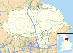
Stackhouse (sometimes written as Stack House), is a hamlet in the civil parish of Giggleswick on the western bank of the River Ribble in North Yorkshire, England.
| Stackhouse | |
|---|---|
 Farm at Stackhouse | |
Location within North Yorkshire | |
| OS grid reference | SD814654 |
| Civil parish | |
| Unitary authority | |
| Ceremonial county | |
| Region | |
| Country | England |
| Sovereign state | United Kingdom |
| Post town | SETTLE |
| Postcode district | BD24 |
| Police | North Yorkshire |
| Fire | North Yorkshire |
| Ambulance | Yorkshire |
History
editStackhouse lies on the western side of the River Ribble in north Ribblesdale, opposite Langcliffe, and 1.2 miles (2 km) north of Giggleswick.[1] The hamlet is located on the road from Settle to Helwith Bridge via Knight Stainforth.[2] The hamlet is mentioned in the Domesday Book as belonging to Roger de Poitu, though with no resident population.[3] The hamlet was listed as having nearly 400 acres (160 ha), and later came under the possession of Furness Abbey c. 1175.[4][5] The hamlet has been recorded across the centuries as: Stacuse (1086), Stachus (1285), Stacho(u)ssum, Stakho(u)ssum (1150–70), and Stackhowse (1592). The name derives from Old Norse meaning "the house near, or for, ricks."[6] Sometimes the hamlet's name is written out as Stack House.[7]
The hamlet was previously in the Township of Giggleswick (along with another hamlet called Rome), and in the wapentake of Staincliffe in the West Riding of Yorkshire.[8][9] The hamlet is now in the civil parish of Giggleswick, in North Yorkshire.[10] James Carr, who came from the hamlet, was a priest at the church in Giggleswick (St Alkelda) and also later founded Giggleswick School.[11] Some of the houses in the village were built for the cotton workers of Langcliffe Mill (opened in 1783) on the opposite bank of the river to Stackhouse, but connected by a bridge.[12][13]
Both the Ribble Way and Dales High Way long-distance paths run through the hamlet. The village is also on National Cycle Route 68 (The Pennine Cycleway).[14][15] A footbridge connects the hamlet over the Ribble with Langcliffe on the eastern bank.[16] The footbridge was swept away in a storm of 1953, but was replaced soon afterwards.[17] To the north west of the village, following the route of the footpath to Feizor, several Bronze Age ring cairns are located on the moor.[1] One was excavated in the 19th century revealing human bones and ivory discs.[18][19]
See also
editReferences
edit- ^ a b "OL41" (Map). Forest of Bowland. 1:25,000. Explorer. Ordnance Survey. 2018. ISBN 978-0-319-24280-3.
- ^ Hartley 1991, p. 81.
- ^ "Stackhouse | Domesday Book". opendomesday.org. Retrieved 28 February 2022.
- ^ Speight 1892, p. 99.
- ^ Clay, Charles Travis; Farrer, William, eds. (2013). Early Yorkshire charters. Volume 11, The Percy fee. Cambridge: Cambridge University Press. p. 325. ISBN 978-1108058346.
- ^ "Stackhouse :: Survey of English Place-Names". epns.nottingham.ac.uk. Retrieved 28 February 2022.
- ^ "Genuki: In 1822, the following places were in the Parish of Giggleswick:, Yorkshire (West Riding)". www.genuki.org.uk. Retrieved 28 February 2022.
- ^ Whitaker 1805, p. 126.
- ^ "Genuki: GIGGLESWICK: Geographical and Historical information from the year 1868., Yorkshire (West Riding)". www.genuki.org.uk. Retrieved 28 February 2022.
- ^ UK Census (2011). "Local Area Report – Giggleswick Parish (E04007084)". Nomis. Office for National Statistics. Retrieved 1 March 2022.
- ^ Slater, Michael J. "Carrs in Langcliffe". www.northcravenheritage.org.uk. Retrieved 28 February 2022.
- ^ "Langcliffe High Mill, Langcliffe, North Yorkshire | Educational Images | Historic England". historicengland.org.uk. Retrieved 1 March 2022.
- ^ Smith, Jonathan (19 October 2019). "A lovely outing along the Ribble and through the limestone". infoweb.newsbank.com. Retrieved 1 March 2022.
- ^ "NCN 68". explore.osmaps.com. Retrieved 1 March 2022.
Use slider to zoom in on Stackhouse
- ^ "Settle to Clapham". sustrans.org.uk. Retrieved 1 March 2022.
- ^ Buckley, Norman (1995). Yorkshire Dales walking : on the level. Wilmslow: Sigma Leisure. p. 52. ISBN 1-85058-439-7.
- ^ Hartley 1991, p. 92.
- ^ Brown, George Henry (1896). On foot round Settle. Settle: Lambert. p. 121. OCLC 12559040.
- ^ "Monument Number 45639". www.heritagegateway.org.uk. Retrieved 1 March 2022.
Sources
edit- Hartley, Marie (1991). The Yorkshire Dales. Otley: Smith Settle. ISBN 1870071727.
- Speight, Harry (1892). The Craven and north-west Yorkshire highlands. Being a complete account of the history, scenery, and antiquities of that romantic district. London: Elliott Stock. OCLC 7219082.
- Whitaker, Thomas Dunham (1805). The history and antiquities of the deanery of Craven in the county of York. London: Nichols and Son. OCLC 1190994017.
