This article needs additional citations for verification. (April 2020) |
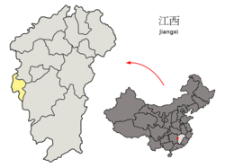
Pingxiang (simplified Chinese: 萍乡; traditional Chinese: 萍鄉; pinyin: Píngxiāng; Wade–Giles: P'ing-hsiang) is a medium-sized prefecture-level city located in western Jiangxi province, People's Republic of China.Pingxiang City is located in the west of Jiangxi Province, bordering Yichun and Ji'an of this province to the east and south, and Zhuzhou and Changsha of Hunan to the northwest.
Pingxiang
萍乡市 Pingsiang | |
|---|---|
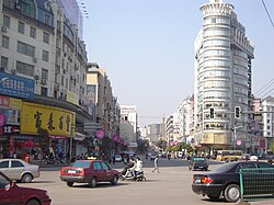
 Downtown Pingxiang | |
 Location of Pingxiang City jurisdiction in Jiangxi | |
| Coordinates (Pingxiang government): 27°39′32″N 113°53′13″E / 27.659°N 113.887°E | |
| Country | People's Republic of China |
| Province | Jiangxi |
| Municipal seat | Anyuan District |
| Government | |
| • Mayor | Li Xiaobao |
| Area | |
| 3,824 km2 (1,476 sq mi) | |
| • Land | 3,824 km2 (1,476 sq mi) |
| • Urban | 1,073 km2 (414 sq mi) |
| • Metro | 1,073 km2 (414 sq mi) |
| Population (2020 census)[1] | |
| 1,804,805 | |
| • Density | 470/km2 (1,200/sq mi) |
| • Urban | 857,716 |
| • Urban density | 800/km2 (2,100/sq mi) |
| • Metro | 857,716 |
| • Metro density | 800/km2 (2,100/sq mi) |
| GDP[2] | |
| • Prefecture-level city | CN¥ 91.2 billion US$ 14.6 billion |
| • Per capita | CN¥ 48,133 US$ 7,728 |
| Time zone | UTC+8 (China Standard) |
| Area code | 0799 |
| ISO 3166 code | CN-JX-03 |
| Website | www |
Pingxiang has a world-famous history and culture and various natural landscapes. There are a large number of old revolutionary sites such as Zongping Alley, the Anyuan Road Miners Club, the Anyuan Road Miners Consumer Cooperative, the Autumn Harvest Uprising military conference site, and the location of the Red Front Army Front Committee. Natural landscapes include Yilong Cave, Wugong Mountain, Yangqi Mountain, etc.[3]
Pingxiang is located between 113°35′~114°17′ east longitude and 27°20′~28°0′ north latitude.[5]Pingxiang City belongs to the hilly area south of the Yangtze River and is dominated by hilly landforms. Most of the east, south and north are mountainous, while the western part is low-lying. Mountains, hills and basins are intricately distributed within the territory, and the landform is relatively complex[6].
Pingxiang is a city situated near the border of Jiangxi with Hunan province. It is approximately 110 kilometers from Changsha, Hunan, and about 260 kilometers from Nanchang, the capital. Most of the area around the city is hilly and mountainous, although the city itself is relatively flat. As a subtropical monsoon climatic city, Pingxiang has mild winters, long and hot summers, with plenty of rainfall. The annual average temperature is 18 °C.The weather characteristics of the four seasons are as follows: spring is humid and mild, but the weather is changeable, sunny and rainy, and there is a saying that "there are no three sunny days in spring"; there are many showers or thunderstorms in summer; autumn is cool, dry, and less rainy; winter is cold and rainy (snow) weather.[7]
| Climate data for Pingxiang (1991–2020 normals, extremes 1981–2010) | |||||||||||||
|---|---|---|---|---|---|---|---|---|---|---|---|---|---|
| Month | Jan | Feb | Mar | Apr | May | Jun | Jul | Aug | Sep | Oct | Nov | Dec | Year |
| Record high °C (°F) | 25.8 (78.4) |
30.5 (86.9) |
35.0 (95.0) |
35.7 (96.3) |
37.3 (99.1) |
37.6 (99.7) |
40.1 (104.2) |
41.0 (105.8) |
39.2 (102.6) |
35.9 (96.6) |
31.8 (89.2) |
25.5 (77.9) |
41.0 (105.8) |
| Mean daily maximum °C (°F) | 9.6 (49.3) |
12.5 (54.5) |
16.6 (61.9) |
23.3 (73.9) |
27.8 (82.0) |
30.8 (87.4) |
34.2 (93.6) |
33.5 (92.3) |
29.8 (85.6) |
24.7 (76.5) |
18.7 (65.7) |
12.5 (54.5) |
22.8 (73.1) |
| Daily mean °C (°F) | 5.9 (42.6) |
8.4 (47.1) |
12.2 (54.0) |
18.2 (64.8) |
22.9 (73.2) |
26.2 (79.2) |
29.1 (84.4) |
28.4 (83.1) |
24.8 (76.6) |
19.5 (67.1) |
13.7 (56.7) |
8.1 (46.6) |
18.1 (64.6) |
| Mean daily minimum °C (°F) | 3.4 (38.1) |
5.6 (42.1) |
9.2 (48.6) |
14.7 (58.5) |
19.2 (66.6) |
22.8 (73.0) |
25.2 (77.4) |
24.8 (76.6) |
21.2 (70.2) |
15.8 (60.4) |
10.1 (50.2) |
5.0 (41.0) |
14.8 (58.6) |
| Record low °C (°F) | −3.9 (25.0) |
−3.9 (25.0) |
−1.7 (28.9) |
1.5 (34.7) |
9.0 (48.2) |
13.4 (56.1) |
17.4 (63.3) |
18.1 (64.6) |
12.6 (54.7) |
2.7 (36.9) |
−1.1 (30.0) |
−9.3 (15.3) |
−9.3 (15.3) |
| Average precipitation mm (inches) | 85.6 (3.37) |
95.6 (3.76) |
193.3 (7.61) |
187.6 (7.39) |
231.5 (9.11) |
252.4 (9.94) |
189.8 (7.47) |
135.5 (5.33) |
84.3 (3.32) |
63.0 (2.48) |
100.1 (3.94) |
70.7 (2.78) |
1,689.4 (66.5) |
| Average precipitation days (≥ 0.1 mm) | 14.7 | 15.0 | 19.7 | 17.2 | 17.2 | 16.6 | 11.3 | 11.0 | 10.1 | 10.6 | 12.9 | 12.4 | 168.7 |
| Average snowy days | 2.0 | 1.8 | 0 | 0 | 0 | 0 | 0 | 0 | 0 | 0 | 0 | 0.4 | 4.2 |
| Average relative humidity (%) | 82 | 82 | 83 | 81 | 81 | 82 | 76 | 78 | 79 | 77 | 79 | 79 | 80 |
| Mean monthly sunshine hours | 56.6 | 64.7 | 79.6 | 111.3 | 122.8 | 134.1 | 226.3 | 217.1 | 151.4 | 134.3 | 101.3 | 93.8 | 1,493.3 |
| Percent possible sunshine | 17 | 20 | 21 | 29 | 29 | 32 | 54 | 54 | 41 | 38 | 32 | 29 | 33 |
| Source: China Meteorological Administration[8][9] | |||||||||||||
History
editArchaeological evidence suggests that Pingxiang was first settled during the Stone Age. During the Han dynasty, it was part of Yichun. In 267, during the time of the Three Kingdoms, it became Pingxiang County, which made it a higher level of administration than what it is today. During the Tang dynasty (618–907), it was part of the Jiangnanxi Circuit, and was called Yuanzhou. During the Ming and Qing Dynasties, Pingxiang became a famous cultural center and produced many literati and historical celebrities, such as the famous poet Tao Yuanming[10].Its name and area of administration were changed many times until 1970, when it assumed its present form.
Administration
editPingxiang has direct jurisdiction over two urban districts, one economic development area, three counties, 28 towns, 18 townships, and 7 sub-districts.
Urban districts:
- Anyuan District (安源区)
- Xiangdong District (湘东区)
- Anyuan Economic Development Zone (安源经济开发区)
Counties:
- Shangli County (上栗县)
- Luxi County (芦溪县)
- Lianhua County (莲花县)
| Map | |||||
|---|---|---|---|---|---|
Demographics
editAs of the 2020 Chinese census, its total population was 1,804,805 inhabitants, of whom 857,716 lived in the built-up areas (or metro), made of two urban districts.
At the end of 2023 and the beginning of 2024, Pingxiang City’s permanent population will be 1.8016 million.[11]
Economy
editAs of 2020, the GDP of Pingxiang was 96.360.2 billion RMB, a 3.6% growth over the previous year. Rural per capita disposable income was 20,831 RMB, a 4.9% growth over 2019, and urban per capita disposable income was 40,405 RMB, a 6.6% growth over 2019 (without regard to inflation).[12]
Resources
editPingxiang has abundant water and mineral resources.[13] Five rivers flow across the land which delivers approximately 2.626 billion cubic meters per year. Coal, iron ore, limestone, kaolin, and granite are the most abundant minerals of the city. Even today, the Pingxiangren, or local people, proudly refer to their city as the "coal center of southern China."
Transportation
editPingxiang is a regional hub for transportation. It is about 1.5 hrs drive to the CSX from downtown of Pingxiang. A couple of highways and the main rail line between Changsha and Nanchang run through the city. The city has had a high-speed railway since September 2014.
Tourism
editWugong (also known as WooKong) mountain is a national well-known place for tourism. It lies in the east of Pingxiang, 45 minutes from downtown. The highest altitude is 1,918 meters while the average altitude is about 1,500 meters. [14]Most of the landscape remains virginal despite some necessary infrastructure that benefit tourists.
Yangqi mountain is famous for the religion of Buddhism. It lies north of Pingxiang, one hour's drive from downtown.
Nielongdong (also known as Sinful Dragon Cave) has a tale which refers to Chinese traditional religion and zodiac. This beautiful area is only twenty minutes north.
The historical buildings of the Anyuan Miners' and Railroad Workers' Club as well as the Anyuan Miners' Strike Memorial Hall preserve the memory on the influence of the miners and railroad workers on the communist movement and are open for public visits.[15]
References
edit- ^ "China: Jiāngxī (Prefectures, Cities, Districts and Counties) - Population Statistics, Charts and Map".
- ^ 江西省统计局、国家统计局江西调查总队 (August 2016). 《江西统计年鉴-2016》. 中国统计出版社. ISBN 978-7-5037-7809-4. Archived from the original on 2018-05-11. Retrieved 2017-06-05.
- ^ "萍乡市--江西省萍乡市地名介绍". www.tcmap.com.cn. Retrieved 2024-12-18.
- ^ "萍实之乡 - 萍乡台办". gd.huaxia.com. Retrieved 2024-12-18.
- ^ 金, 洋 (2022-08-28). "【萍乡】萍乡地理".
- ^ 中国县域 (2022-12-15). "萍乡市". 中国县域. Retrieved 2024-12-18.
- ^ 中国县域 (2022-12-15). "萍乡市". 中国县域. Retrieved 2024-12-18.
- ^ 中国气象数据网 – WeatherBk Data (in Simplified Chinese). China Meteorological Administration. Retrieved 28 June 2023.
- ^ 中国气象数据网 (in Simplified Chinese). China Meteorological Administration. Retrieved 28 June 2023.
- ^ "探秘萍乡:历史文化与特色美食的交融_城市_发展_游客". www.sohu.com. Retrieved 2024-12-18.
- ^ "2024年萍乡市人口总人数口有多少和第七次人口普查结果 年龄金字塔结构 民族组成情况-红黑人口库". www.hongheiku.com. Retrieved 2024-12-18.
- ^ "萍乡市2020年国民经济和社会发展统计公报". Pingxiang Government. 2021-11-02. Retrieved 2021-12-31.
- ^ "萍乡市自然资源和规划局以高质量服务促进高质量发展纪实-中国网生态中国". stzg.china.com.cn. Retrieved 2024-12-18.
- ^ "中国风景名胜区协会". www.china-npa.org. Retrieved 2024-12-18.
- ^ "Anyuan Bowuguan". Retrieved 2020-05-18.