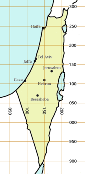
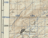
The Palestine grid was the geographic coordinate system used by the Survey Department of Palestine.

The system was chosen by the Survey Department of the Government of Palestine in 1922.[1] The projection used was the Cassini-Soldner projection. The central meridian (the line of longitude along which there is no local distortion) was chosen as that passing through a marker on the hill of Mar Elias Monastery south of Jerusalem.[1] The false origin (zero point) of the grid was placed 100 km to the south and west of the Ali el-Muntar hill that overlooks Gaza city.[1] The unit length for the grid was the kilometre; the British units were not even considered.[1]
At the time the grid was established, there was no intention of mapping the lower reaches of the Negev Desert, but this did not remain true.[1] Those southern regions having a negative northing coordinate then became a source of confusion, which was solved by adding 1000 to the negative northings, running from about 900 to 1000 and from 0 to 300.[1] For some military purposes, 1000 was added to the northing coordinates of all locations, so that they then ranged from about 900 to about 1300.[1]

During World War II, a Military Palestine Grid was used that was similar to the Palestine Grid but used the transverse Mercator projection.[2] The difference between the two projections was only a few metres.[2]
After the establishment of the State of Israel, the Palestine grid continued to be used under the name of the Israel Grid or the Israeli Cassini Soldner (ICS) grid, now called the "Old Israeli Grid", with 1,000 km added to the northing component to make the northing range continuous. It was replaced by the Israeli Transverse Mercator grid in 1994. The Palestine grid is still commonly used to specify locations in the historical and archaeological literature.
Specifying locations
editThe basic way of specifying a location on the Palestine grid is to write the east-west coordinate followed by the north-south coordinate using 3 digits each. For example, the Dome of the Rock is at 172132. This specifies the location within one kilometre. If more precision is required, extra digits can be added to each coordinate; for example, 17241317 gives the Dome of the Rock to within 100 metres. Many authors separate the two coordinates with punctuation for readability purposes, for example 172-132 or 172/132.[3]
References
edit- ^ a b c d e f g Dov Gavish (2005). The Survey of Palestine under the British Mandate, 1920–1948. London and New York: RoutledgeCurzon. pp. 73–75.
- ^ a b Dov Gavish (2005). The Survey of Palestine under the British Mandate, 1920–1948. London and New York: RoutledgeCurzon. pp. 219–223.
- ^ For example, the location of Khirbet esh Sheik Mohammed is given as 1417.1984 in D. Pringle (1986). The Red Tower (al-Burj al-ahmar): Settlement in the Plain of Sharon at the time of the Crusaders and the Mamluks A.D. 1099–1516. Jerusalem Monograph Series no. 1. London: British School of Archaeology in Jerusalem. p. 71.
Further reading
edit- Mugnier, Clifford J. (August 2000), "Grids & Datums. The State of Israel" (PDF), Photogrammetric Engineering and Remote Sensing, 66: 915–917, 933