This article needs additional citations for verification. (May 2016) |
Narail (Bengali: নড়াইল, pron: nɔɽail) is a district in south-western Bangladesh. It is a part of Khulna Division.[4]
Narail district
নড়াইল | |
|---|---|
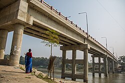
 Sheikh Russel Bridge | |
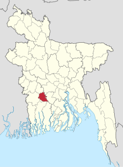
 Location of Narail District in Bangladesh | |
 Expandable map of Narail District | |
| Coordinates: 23°08′N 89°30′E / 23.13°N 89.50°E | |
| Country | |
| Division | Khulna |
| Headquarters | Narail |
| Government | |
| • Deputy Commissioner | Anjuman Ara |
| Area | |
| • Total | 967.99 km2 (373.74 sq mi) |
| Population | |
| • Total | 788,671 |
| • Density | 810/km2 (2,100/sq mi) |
| Postal code | 7600 |
| Area code | 0481 |
| ISO 3166 code | BD-43 |
| HDI (2022) | high · 2nd of 20 |
| Website | www |
History
editNarail town was named after a feudal lord (a zamindar). The zamindars established a market at Roopgonj, also named after a zamindar. They established a post office for the first time in the district during British Raj near Rotongonj, named after yet another member of the zamindar's family. They modernised Narail, and promoted culture, sports and education.
The large playing field, Kuriddobe, was a gift for the town by the zamindar's family. They introduced a football competition, with a shield given to the champions, a cup for the runners-up, and medals for all players from the early twentieth century.
One of the zamindars moved away from Narail, settled in Hatbaria, and established another large manor (Jomidarbaari).
Geography
editNarail District has an area of 967.99 square kilometres (373.74 sq mi). It is located to the south of Magura District, north of Khulna District, with the Faridpur District and Gopalganj District on the east, and Jessore District to the west.
Its average temperature ranges between 11.2 and 37.1 °C (52.2 and 98.8 °F) and has a yearly rainfall of 1,467 mm (57.8 in).
Through the district flow the Madhumati, Nabaganga, Bhairab, and Chitra rivers. There are many beels and haors, the most noted of which is Chachuri Beel.
Land area:
- Cultivable area: 176,504-acre (714 km2)
- Fallow land: 25,090-acre (102 km2)
- Forest area: 10 acres
- Area irrigated: 36,208-acre (147 km2)
- River area: 8,562-acre (35 km2)
Administration
editNarail District was established in 1984. It is divided into three upazilas:
- Kalia Upazila and
The upazilas are further divided into Narail Sadar and Kalia municipalities, and 39 Union Parishads. These are subdivided into 18 wards, 43 mahallas, 445 mouzas, and 651 villages.[4]
Points of interest
editNarail Victoria College and Collegiate School is one of the oldest modern high schools in Bangladesh, established in 1858 by the landlords of Narail who were proponents of education. They also established a girls' school, a rarity in Bangladesh at that time. This was the Shib Shankar Memorial Girls' School. This school closed down due to lack of funding after the landlords left for India. It was reopened by some local enthusiasts, like J. Bhattacharjee, S. Biswas and B. Bhowmic. They borrowed furnishings from the neighbours. They went house to house soliciting parents to send their children to the school.
Narail Palace was one of the biggest landlord mansions in Bengal. When the Hindu landlords left for Kolkata after the partition of India, the mansion was looted and vandalised, and gradually collapsed. There are still some remains present, including the Kaalibaari (temple of goddess Kali), Shibmondir (temple of Shiva) and the Bandha ghaat on the River Chitra. Some local people initially continued the famous Durga Puja in the mansion, but this was discontinued after a few years. Part of the building was used for some time as a government office. Due to lack of maintenance, it gave in.
Kalia Palace was another large landlord mansions in Bengal. Some landlords lived in Naragati. Naragati was a thana in the British period. The predecessor of Robi Sankar & Uday Sankar lived in Kalia.
The famous writer Bankim Chandra Chattopadhyay was a magistrate in Narail. His book Neelkuthi was based on the forceful cultivation of indigo in Narail by the East India Company.
Sheikh Mohammed Sultan (10 August 1923 – 10 October 1994; better known as SM Sultan, Bengali: এস এম সুলতান), was a Bengali avant-garde artist who worked in painting and drawing, was born in Narail District. His fame rests on his striking depictions of exaggeratedly muscular farmers engaged in the activities of their everyday lives.[1] He is the son of Sheikh Mohammed Mecher Ali & Mohammed Meherunnesa.
Narail was once declared independent from the British Raj by Shorola di (Sister Shorola), as she was known at the time by her followers of the independence movement of India. But this "independence" lasted for only three days.
Transport
editThe town of Narail is the road transport hub of the district. To the west it is connected by regional highway R750 to Jessore, about 32 km away. R720 runs north 50 km to Magura. Within the district, Zilla road Z7503 runs east to Lohagara and on to the Kalna ferry ghat on the Madhumati River. Z7502 runs south, across the Nabaganga River at Baroipara Ghat by ferry, and on to Kalia.[5]
Demographics
edit| Year | Pop. | ±% p.a. |
|---|---|---|
| 1981 | 588,812 | — |
| 1991 | 655,720 | +1.08% |
| 2001 | 698,447 | +0.63% |
| 2011 | 721,668 | +0.33% |
| 2022 | 788,671 | +0.81% |
| Sources:[2][6] | ||
According to the 2022 Census of Bangladesh, Narail District had 195,660 households and a population of 788,671 with an average 3.98 people per household. Among the population, 148,027 (18.77%) inhabitants were under 10 years of age. The population density was 815 people per km2. Narail District had a literacy rate (age 7 and over) of 74.66%, compared to the national average of 74.80%, and a sex ratio of 1056 females per 1000 males. Approximately, 22.14% of the population lived in urban areas. Ethnic population was 8,278 (1.05%).[2]
Religion
edit| Religion | Population (1941)[7]: 84–85 | Percentage (1941) | Population (2022)[2] | Percentage (2022) |
|---|---|---|---|---|
| Islam | 173,674 | 50.10% | 663,961 | 84.19% |
| Hinduism | 172,697 | 49.82% | 124,465 | 15.78% |
| Others [b] | 269 | 0.08% | 245 | 0.03% |
| Total Population | 346,640 | 100% | 788,671 | 100% |
In 2011, Muslims were 81.28% of the population while Hindus are 18.65% of the population. The population of Hindus has declined rapidly in the district since Partition, when the two communities were in equal numbers.[6]
The district of Narail has 1675 mosques, 248 temples, 51 churches, seven tombs, and 11 shrines.
The Radha Raman Smriti Tirtha Mandir, founded by Shri Tribhanga Brahmachary (Babaji of Shri Shri Bhagvat Sevashram Sangh) at Debbhog is a prominent place to visit, as are Nishinath Tola in Rupganj and Lakkhipasha Thakurbari.
Notable residents
edit- Jadunath Majumdar – writer, editor
- Chief Engineer Md. Sarwar Shaikh (Retd) - Military Engineer Services (MES)
- SM Sultan – artist
- Ravi Shankar – sitar master & organiser of The Concert for Bangladesh
- Birshrestha Nur Mohammad Sheikh – freedom fighter of Bangladesh
- Sharif Khasruzzaman – freedom fighter of Bangladesh, politician, businessman and Member of the Parliament from 1991-96 and 1996-2001 terms for Bangladesh Awami League
- Major General Sheikh Mohammad Aman Hasan (retd) – a two-star general in the Bangladesh Army, who notably served as the directorate general (DG) of Special Security Force (SSF) from 2012 until his retirement in 2016 was born in Narail on 15 April 1960
- Mashrafe Bin Mortoza – former cricketer and captain of the Bangladesh national cricket team. popularly Known as "Narail Express". He was elected as Member of the Parliament 11th general election on 30 December 2019 as a Bangladesh Awami League candidate.
- Suvra Mukherjee – former First Lady of India, wife of Former President of India Pranab Mukherjee
- Bijoy Sarkar – poet, baul singer, lyricist, and composer
- Kamal Dasgupta – music director and eminent film composer
- Syed Nausher Ali – politician
- Amal Sen – politician
- Sheikh Abdus Salam – martyred intellectual
- Md. Kabirul Haque – politician, businessman and Member of the Parliament 11th general election on 30 December 2019 as a Bangladesh Awami League candidate (Seats, Narail-1).
- Shamoli Ray is a Bangladeshi competitive archer. At the 2016 Summer Olympics in Rio de Janeiro, she competed as a lone archer for the Bangladeshi team in the women's individual recurve through a tripartite invitation
- Nihar Ranjan Gupta – Bengali novelist
- Brigadier General (Retd) SK Abu Bakr, he is a Bangladesh Awami League politician and the former member of parliament for Narail-2.
- Avishek Das (born 5 September 2001) is a Bangladeshi cricketer. He made his List A debut on 15 March 2020, for Old DOHS Sports Club, in the 2019–20 Dhaka Premier Division Cricket League. Prior to his List A debut, he was named in Bangladesh's squad for the 2020 Under-19 Cricket World Cup.
See also
editNotes
edit- ^ Narail subdivision of Jessore district, excluding Alfadanga thana
- ^ Including Jainism, Christianity, Buddhism, Zoroastrianism, Judaism, Ad-Dharmis, or not stated
References
edit- ^ Population and Housing Census 2022 - District Report: Narail (PDF). District Series. Dhaka: Bangladesh Bureau of Statistics. June 2024. ISBN 978-984-475-240-5.
- ^ a b c d e Population and Housing Census 2022 National Report (PDF). Vol. 1. Bangladesh Bureau of Statistics. November 2023.
- ^ https://globaldatalab.org/shdi/table/shdi/BGD/?levels=1+4&years=2022&interpolation=0&extrapolation=0
- ^ a b Munshi, Md. Hamidul Haq (2012). "Narail District". In Islam, Sirajul; Jamal, Ahmed A. (eds.). Banglapedia: National Encyclopedia of Bangladesh (Second ed.). Asiatic Society of Bangladesh.
- ^ "RHD Road Network, Khulna Zone" (PDF). Roads and Highways Department. May 2005. Retrieved 25 July 2014.
- ^ a b "Bangladesh Population and Housing Census 2011 Zila Report – Narail" (PDF). bbs.gov.bd. Bangladesh Bureau of Statistics.
- ^ "Census of India, 1941 Volume VI Bengal Province" (PDF). Retrieved 13 August 2022.