This article needs additional citations for verification. (December 2009) |
52°00′32″N 0°43′16″W / 52.009°N 0.721°W
| Milton Keynes South West | |
|---|---|
| Former borough constituency for the House of Commons | |
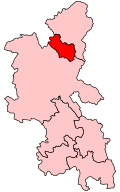
 Boundary of Milton Keynes South West in Buckinghamshire for the 2005 general election | |
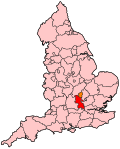
 Location of Buckinghamshire within England | |
| County | Buckinghamshire |
| 1992–2010 | |
| Seats | One |
| Created from | Milton Keynes and Buckingham[1] |
| Replaced by | Milton Keynes North, Milton Keynes South |
Milton Keynes South West was a constituency represented in the House of Commons of the Parliament of the United Kingdom from 1992 to 2010. It elected one Member of Parliament (MP) by the first past the post system of election.
History
editConstruction of Milton Keynes began in 1967, as a new town. Until 1983, it was part of the Buckingham constituency. As its population grew, Milton Keynes then gained its own constituency, which was taken by William Benyon of the Conservative Party.
Uniquely outside the normal cycle of periodic reviews by the Boundary Commission, the continuing expansion in the population of Milton Keynes led to this constituency being divided in two for the 1992 general election (Milton Keynes South West and North East Milton Keynes).
The new South West constituency was taken by Barry Legg of the Conservatives, who lost the seat to Labour's Phyllis Starkey in the 1997 election. The Milton Keynes South West seat was abolished, and replaced with the Milton Keynes South seat for the 2010 general election. Phyllis Starkey ran in the Milton Keynes South seat, but lost to the Conservative candidate Iain Stewart.
Boundaries
editThe constituency was one of two covering the Borough of Milton Keynes. It included the more urban parts of the borough: Bletchley, Fenny Stratford, Loughton, the Shenleys, Stony Stratford and more modern districts in between.
The constituency consisted of 12 electoral wards of the Borough of Milton Keynes: Church Green, Denbigh, Eaton, Fenny Stratford, Loughton, Manor Farm, Newton, Stony Stratford, Whaddon, Wolverton, Wolverton Stacey Bushes, and Woughton.[2]
The Stony Stratford, Wolverton and Wolverton Stacey Bushes wards were transferred from the Buckingham constituency.
Boundary review
editFollowing their review of parliamentary representation in Buckinghamshire, the Boundary Commission for England created two new seats for Milton Keynes, effectively replacing the current South West/North East division with a North and South division from the 2010 general election.
Milton Keynes North was formed from the electoral wards of Bradwell, Campbell Park, Hanslope Park, Linford North, Linford South, Middleton, Newport Pagnell North, Newport Pagnell South, Olney, Sherington, Stantonbury, and Wolverton.[3]
Milton Keynes South was formed from the electoral wards of Bletchley and Fenny Stratford, Danesborough, Denbigh, Eaton Manor, Emerson Valley, Furzton, Loughton Park, Stony Stratford, Walton Park, Whaddon, and Woughton.[3]
Members of Parliament
edit| Election | Member[4] | Party | |
|---|---|---|---|
| 1992 | Barry Legg | Conservative | |
| 1997 | Phyllis Starkey | Labour | |
| 2010 | Constituency abolished: see Milton Keynes North and Milton Keynes South | ||
Elections
editElections in the 2000s
edit| Party | Candidate | Votes | % | ±% | |
|---|---|---|---|---|---|
| Labour | Phyllis Starkey | 20,862 | 42.4 | −7.1 | |
| Conservative | Iain Stewart | 16,852 | 34.2 | 0.0 | |
| Liberal Democrats | Neil Stuart | 7,909 | 16.1 | +5.5 | |
| UKIP | George Harlock | 1,750 | 3.6 | +1.7 | |
| Green | Alan Francis | 1,336 | 2.7 | +0.6 | |
| Majority | 4,010 | 8.2 | −7.1 | ||
| Turnout | 49,209 | 59.8 | −2.5 | ||
| Labour hold | Swing | −3.6 | |||
| Party | Candidate | Votes | % | ±% | |
|---|---|---|---|---|---|
| Labour | Phyllis Starkey | 22,484 | 49.5 | −4.3 | |
| Conservative | Iain Stewart | 15,506 | 34.2 | +0.7 | |
| Liberal Democrats | Nazar Mohammed | 4,828 | 10.6 | −1.4 | |
| Green | Alan Francis | 957 | 2.1 | New | |
| UKIP | Clive Davies | 848 | 1.9 | New | |
| Legalise Cannabis | Patman Denning | 500 | 1.1 | New | |
| Socialist Alliance | Dave Bradbury | 261 | 0.6 | New | |
| Majority | 6,978 | 15.3 | −5.0 | ||
| Turnout | 45,384 | 62.3 | −9.1 | ||
| Labour hold | Swing | ||||
Elections in the 1990s
edit| Party | Candidate | Votes | % | ±% | |
|---|---|---|---|---|---|
| Labour | Phyllis Starkey | 27,298 | 53.8 | +16.4 | |
| Conservative | Barry Legg | 17,006 | 33.5 | −13.1 | |
| Liberal Democrats | Peter Jones | 6,065 | 12.0 | −2.5 | |
| Natural Law | Hugh Kelly | 389 | 0.8 | +0.4 | |
| Majority | 10,092 | 20.3 | N/A | ||
| Turnout | 50,758 | 71.4 | −5.6 | ||
| Labour gain from Conservative | Swing | +14.6 | |||
| Party | Candidate | Votes | % | ±% | |
|---|---|---|---|---|---|
| Conservative | Barry Legg | 23,840 | 46.6 | ||
| Labour | Kevin Wilson | 19,153 | 37.4 | ||
| Liberal Democrats | Chris Pym | 7,429 | 14.5 | ||
| Green | Caroline Field | 525 | 1.0 | ||
| Natural Law | H. Kelly | 202 | 0.4 | ||
| Majority | 4,687 | 9.2 | |||
| Turnout | 51,149 | 77.0 | |||
| Conservative win (new seat) | |||||
See also
editNotes and references
edit- ^ "UK Parliamentary Constituency: 'Milton Keynes South West', April 1992 – April 1997". ElectionWeb Project. Cognitive Computing Limited. Archived from the original on 15 December 2019. Retrieved 2 March 2016.
- ^ "The Parliamentary Constituencies (England) (Miscellaneous Changes) Order 1990". legislation.gov.uk. Retrieved 8 February 2019.
- ^ a b "The Parliamentary Constituencies (England) Order 2007". legislation.gov.uk. Retrieved 8 February 2019.
- ^ Leigh Rayment's Historical List of MPs – Constituencies beginning with "M" (part 2)
- ^ "Election Data 2005". Electoral Calculus. Archived from the original on 15 October 2011. Retrieved 18 October 2015.
- ^ "Election Data 2001". Electoral Calculus. Archived from the original on 15 October 2011. Retrieved 18 October 2015.
- ^ "Election Data 1997". Electoral Calculus. Archived from the original on 15 October 2011. Retrieved 18 October 2015.
- ^ "Election Data 1992". Electoral Calculus. Archived from the original on 15 October 2011. Retrieved 18 October 2015.
- ^ "Politics Resources". Election 1992. Politics Resources. 9 April 1992. Archived from the original on 24 July 2011. Retrieved 6 December 2010.
External links
edit- Milton Keynes South West UK Parliament constituency (boundaries April 1997 – April 2010) at MapIt UK