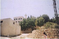
Mais al-Jabal or Mais aj-Jabal (Arabic: ميس الجبل) is a municipality in the Marjayoun District in Lebanon.
Mais al-Jabal
ميس الجبل | |
|---|---|
Municipality | |
 Abi Zar mosque in Mais al-Jabal | |
| Coordinates: 33°10′10″N 35°31′32″E / 33.16944°N 35.52556°E | |
| Grid position | 198/286 PAL |
| Country | |
| Governorate | Nabatieh Governorate |
| District | Marjayoun District |
| Elevation | 630 m (2,070 ft) |
| Time zone | UTC+2 (EET) |
| • Summer (DST) | UTC+3 (EEST) |
| Dialing code | +961 |
Etymology
editAccording to E. H. Palmer, the name Meis comes from the name of a tree.[1]
Location
editThe municipality of Mais al-Jabal is located in the Marjayoun District, one of the eight mohafazats (governorates) of Lebanon. Mais al-Jabal is 114 kilometers (70.8396 mi) away from Beyrouth (Beirut) the capital of Lebanon. Its elevation is 630 meters (2067.03 ft - 688.968 yd) above sea level. Mais al-Jabal surface stretches for 1924 hectares (19.24 km2 - 7.42664 mi2).[citation needed]
History
editIn 1596, it was named as a village, Mis, in the Ottoman nahiya (subdistrict) of Tibnin under the liwa' (district) of Safad, with a population of 75 households and 11 bachelors, all Muslim. The villagers paid a fixed tax-rate of 25% on agricultural products, such as wheat, barley, summer crops, olive trees, vegetable and fruit garden or orchard, goats, beehives; in addition to occasional revenues, a press for olive oil or grape syrup and a winter pastures; a total of 12,860 akçe.[2][3]
In 1881, the PEF's Survey of Western Palestine (SWP) found here: "ancient remains; one olive-press and two sarcophagi on the east side."[4] They further described it: "A large village in two parts, containing about 700 Metawileh, on low ridge, surrounded by figs, olives, and arable land. There is a birket near the village, and three good springs to the north, besides cisterns."[5]
Modern era
editOn October 1, 2024, the IDF claimed that since the onset of the Israel–Hezbollah conflict in October 2023 and leading up to the October 2024 ground operation, it has destroyed 91 Hezbollah targets in Mais al-Jabal, including 13 lookout posts and various weapons, with tunnels measuring nearly 12 meters deep and located just 30 meters from the Blue Line.[6]
Demographics
editIn 2014 Muslims made up 99.58% of registered voters in Mais al-Jabal. 98.33% of the voters were Shiite Muslims.[7]
Shrine
editThe village holds a Shia shrine for the prophet's companion Abu Dharr. Another Shia shrine to Abu Dharr is located in Sarepta.[8]
Educational Establishments
edit| Educational establishments | Mais al-Jabal (2005-2006) | Lebanon (2005-2006) |
|---|---|---|
| Number of Schools | 3 | 2788 |
| Public School | 2 | 1763 |
| Private School | 1 | 1025 |
| Students schooled in the public schools | 435 | 439905 |
| Students schooled in the private schools | 144 | 471409 |
References
edit- ^ Palmer, 1881, p. 29
- ^ Hütteroth and Abdulfattah, 1977, p. 181
- ^ Note that Rhode, 1979, p. 6 writes that the register that Hütteroth and Abdulfattah studied was not from 1595/6, but from 1548/9
- ^ Conder and Kitchener, 1881, SWP I, p. 136
- ^ Conder and Kitchener, 1881, SWP I, p. 95
- ^ "IDF invasion of southern Lebanon meets no Hezbollah resistance". The Jerusalem Post. 2024-10-01. Retrieved 2024-10-01.
- ^ https://lub-anan.com/المحافظات/النبطية/مرجعيون/ميس-الجبل/المذاهب/
- ^ Rihan, Mohammad (2014). The Politics and Culture of an Umayyad Tribe: Conflict and Factionalism in the Early Islamic Period. Bloomsbury Publishing. p. 195. ISBN 9780857736208 – via books.google.com.
Bibliography
edit- Conder, C.R.; Kitchener, H.H. (1881). The Survey of Western Palestine: Memoirs of the Topography, Orography, Hydrography, and Archaeology. Vol. 1. London: Committee of the Palestine Exploration Fund.
- Hütteroth, W.-D.; Abdulfattah, K. (1977). Historical Geography of Palestine, Transjordan and Southern Syria in the Late 16th Century. Erlanger Geographische Arbeiten, Sonderband 5. Erlangen, Germany: Vorstand der Fränkischen Geographischen Gesellschaft. ISBN 3-920405-41-2.
- Palmer, E.H. (1881). The Survey of Western Palestine: Arabic and English Name Lists Collected During the Survey by Lieutenants Conder and Kitchener, R. E. Transliterated and Explained by E.H. Palmer. Committee of the Palestine Exploration Fund.
- Rhode, H. (1979). Administration and Population of the Sancak of Safed in the Sixteenth Century. Columbia University.
External links
edit- http://yameis.org/
- Meiss Ej Jabal, Localiban
- Survey of Western Palestine, Map 2: IAA, Wikimedia commons
