This article needs additional citations for verification. (August 2013) |
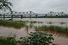
Long Biên Bridge (Vietnamese: Cầu Long Biên) is a historic cantilever bridge across the Red River that connects two districts, Hoàn Kiếm and Long Biên of the city of Hanoi, Vietnam. It was originally called Paul Doumer Bridge.


History
editDuring French colonial rule
editThe bridge was built in 1899–1902 by the architects Daydé & Pillé of Paris, and opened in 1903.[1] Before North Vietnam's independence in 1954, it was called Paul-Doumer Bridge, named after Paul Doumer – the governor-general of French Indochina and then French president. At 2.4 kilometres (1.5 mi) in length,[1] it was, at that time, one of the longest bridges in Asia. For the French colonial government, the construction was of strategic importance in securing control of northern Vietnam. From 1899 to 1902, more than 3,000 Vietnamese took part in the construction.
Vietnam War
editIt was heavily bombed during Vietnam War due to its critical position (the only bridge at that time across the Red River connecting Hanoi to the main port of Haiphong). The first attack took place in 1967, and the center span of the bridge was felled by an attack by 20 United States Air Force (USAF) F-105 fighter-bombers on 11 August.[2] CIA reports noted that the severing of the bridge did not appear to have caused as much disruption as had been expected.[3]
On 10 May 1972 the bridge was attacked in the first Operation Linebacker attacks in response to the North Vietnamese Easter Offensive. On 13 May the USAF announced that several spans of the bridge had been destroyed by laser-guided bombs (LGB).[4]: N-3 On 9 August the USAF announced that another LGB attack had disabled the newly repaired bridge.[4]: N-5 On 11 September the USAF attacked the bridge again as repairs were nearing completion.[4]: N-5
Modern day
editSome parts of the original structure remain intact, while large sections have been built later to repair the holes. Only half the bridge retains its original shape. A project with support and loan from the French government is currently in progress to restore the bridge to its original appearance.[when?][needs update]
Today trains, mopeds, bicycles and pedestrians use the dilapidated bridge, while all other traffic is diverted to the nearby Chương Dương Bridge and some other bridges: Thanh Trì Bridge, Thăng Long Bridge, Vĩnh Tuy Bridge, and Nhật Tân Bridge.
Under the bridge, poor families live in boats on the Red River, coming from many rural areas of Vietnam.
Image gallery
edit-
The pedestrian and two-wheeled vehicles pathway
-
The bridge's iron beams
-
The bridge in 1915
-
Long Biên Bridge as seen from the Red River
References
edit- ^ a b Long Bien: Historic Hanoi bridge with an uncertain future by Petroc Trelawny, BBC News Magazine, 18 August 2013. Retrieved 18 August 2013.
- ^ Sources: 388th TFW official history & Rolling Thunder Digest (CINCPAC) Edition Five, Jul–Sep 1967
- ^ "Bombing of the Cau Long Bien Bridge in Hanoi on 11 August and the effect of the closing of the bridge on transportation in Hanoi CIA Intelligence Cable 1 September 1967 Doc No/ESDN: 0000505896" (PDF). Central Intelligence Agency. 1 September 1967. Archived from the original (PDF) on 3 March 2016. Retrieved 2 September 2020.
- ^ a b c "Command History January 1972 - March 1973 Volume II" (PDF). Military Assistance Command, Vietnam. 15 July 1973. Retrieved 12 September 2021. This article incorporates text from this source, which is in the public domain.