Kbelany (German: Wellana) is a municipality and village in Plzeň-North District in the Plzeň Region of the Czech Republic. It has about 100 inhabitants.
Kbelany | |
|---|---|
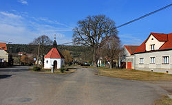
 Centre of Kbelany | |
| Coordinates: 49°43′57″N 13°7′35″E / 49.73250°N 13.12639°E | |
| Country | |
| Region | Plzeň |
| District | Plzeň-North |
| First mentioned | 1239 |
| Area | |
• Total | 6.88 km2 (2.66 sq mi) |
| Elevation | 403 m (1,322 ft) |
| Population (2024-01-01)[1] | |
• Total | 131 |
| • Density | 19/km2 (49/sq mi) |
| Time zone | UTC+1 (CET) |
| • Summer (DST) | UTC+2 (CEST) |
| Postal code | 330 23 |
| Website | www |
Etymology
editThe name was probably derived from the personal name Kbel, or referred to settlers who came from a place called Kbel or Kbely.[2]
Geography
editKbelany is located about 17 kilometres (11 mi) west of Plzeň. It lies in the Plasy Uplands. The highest point is the hill Harabaska at 502 m (1,647 ft) above sea level.
History
editThe first written mention of Kbelany is from 1239, when the village was owned by the Kladruby Monastery. The monastery owned Kbelany until its abolition in the second half of the 18th century. During the 19th century, the village expanded considerably. In 1938, the municipality was annexed by Nazi Germany. After World War II, the German-speaking population was expelled.[3]
Demographics
edit
|
|
| ||||||||||||||||||||||||||||||||||||||||||||||||||||||
| Source: Censuses[4][5] | ||||||||||||||||||||||||||||||||||||||||||||||||||||||||
Transport
editThe D5 motorway (part of the European route E50) from Plzeň to the Czech-German border in Rozvadov runs along the southern municipal border.
Kbelany is located on the railway line of local importance from Nýřany to Heřmanova Huť. The train station in the municipality is called Přehýšov after the neighbouring municipality of Přehýšov.[6]
Sights
editKbelany is poor in monuments. The only protected cultural monuments are a stone conciliation cross and a border stone, both from the 16th century.[7] A landmark is the Chapel of the Visitation of the Virgin Mary, located in the centre of the village.
References
edit- ^ "Population of Municipalities – 1 January 2024". Czech Statistical Office. 2024-05-17.
- ^ Profous, Antonín (1949). Místní jména v Čechách II: CH–L (in Czech). p. 217.
- ^ "Historie" (in Czech). Obec Kbelany. Retrieved 2023-12-08.
- ^ "Historický lexikon obcí České republiky 1869–2011" (in Czech). Czech Statistical Office. 2015-12-21.
- ^ "Population Census 2021: Population by sex". Public Database. Czech Statistical Office. 2021-03-27.
- ^ "Detail stanice Přehýšov" (in Czech). České dráhy. Retrieved 2023-12-08.
- ^ "Výsledky vyhledávání: Kulturní památky, obec Kbelany". Ústřední seznam kulturních památek (in Czech). National Heritage Institute. Retrieved 2024-08-27.


