Size of this preview: 618 × 599 pixels. Other resolutions: 247 × 240 pixels | 495 × 480 pixels | 792 × 768 pixels | 1,056 × 1,024 pixels | 1,827 × 1,772 pixels.
Original file (1,827 × 1,772 pixels, file size: 534 KB, MIME type: image/png)
File history
Click on a date/time to view the file as it appeared at that time.
| Date/Time | Thumbnail | Dimensions | User | Comment | |
|---|---|---|---|---|---|
| current | 04:45, 23 December 2011 |  | 1,827 × 1,772 (534 KB) | J. Patrick Fischer | Fautrilau -> Faturilau (typo) |
| 13:47, 16 November 2010 |  | 1,827 × 1,772 (534 KB) | J. Patrick Fischer | typo Foho-Ai-Lico | |
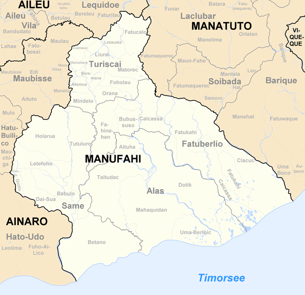
| 10:20, 23 December 2009 |  | 1,827 × 1,772 (535 KB) | J. Patrick Fischer | New version by using File:Administrative map of the Manufahi district of East Timor.png of Maximilian Dörrbecker (Chumwa) and new geographical names and spelling according Ministerial Document 199/2009 | |
| 23:20, 30 December 2008 |  | 419 × 255 (49 KB) | J. Patrick Fischer | {{Information |Description={{de|1=Sucos des Distrikts Manufahi/Osttimor nach der Neustrukturierung 2004}} |Source=Own work |Author=J. Patrick Fischer |Date= |Permission= |other_versions= }} <!--{{ImageUpload|full}}--> [[Catego |
File usage
The following 3 pages use this file:
Global file usage
The following other wikis use this file:
- Usage on ce.wiki.x.io
- Usage on de.wiki.x.io
- Usage on frr.wiki.x.io
- Usage on fr.wiki.x.io
- Usage on hy.wiki.x.io
- Usage on id.wiki.x.io
- Usage on it.wiki.x.io
- Usage on ja.wiki.x.io
- Usage on ko.wiki.x.io
- Usage on pl.wiki.x.io
- Usage on pt.wiki.x.io
- Usage on ru.wiki.x.io
- Usage on tet.wiki.x.io
- Manufahi
- Lista administrativu Timor-Leste nian
- Alas (postu administrativu)
- Fatu-Berliu (postu administrativu)
- Same (postu administrativu)
- Turiskai (postu administrativu)
- Aituha
- Dotik
- Mahakidan
- Taitudak
- Umaberloik
- Bubususu
- Fahinehan
- Fatukahi
- Kaikasa
- Klakuk
- Babulu (Same)
- Betano
- Dai-Sua
- Grotu
- Holarua
- Rotuto
- Tutuluro
- Aitemua
- Beremana
- Fatukalo
- Foholau
View more global usage of this file.
