No higher resolution available.
Aftermath_of_Manzikert.png (800 × 369 pixels, file size: 135 KB, MIME type: image/png)
| This is a file from the Wikimedia Commons. Information from its description page there is shown below. Commons is a freely licensed media file repository. You can help. |
Summary
| Description |
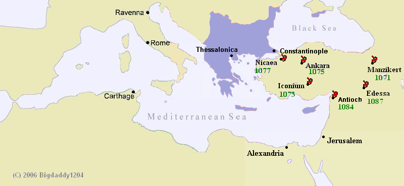
English: Map showing when and how the Turks took Anatolia |
||
| Date | 10 January 2008 (original upload date) | ||
| Source | Own work (Original text: self-made) | ||
| Author | Tourskin (talk) 04:43, 10 January 2008 (UTC), based on BigDaddy1204's maps. | ||
| Other versions |
|

Licensing
| This work has been released into the public domain by its author, Gabr-el at English Wikipedia. This applies worldwide. In some countries this may not be legally possible; if so: Gabr-el grants anyone the right to use this work for any purpose, without any conditions, unless such conditions are required by law. |
Original upload log
The original description page was here. All following user names refer to en.wikipedia.
| Date/Time | Dimensions | User | Comment |
|---|---|---|---|
| 2008-01-10 04:43 | 800×369× (138258 bytes) | Gabr-el | {{Information |Description=Map showing when and how the Turks took Anatolia |Source=self-made |Date= |Location= |Author=~~~~, based on BigDaddy1204's maps. |Permission= |other_versions= }} |
File history
Click on a date/time to view the file as it appeared at that time.
| Date/Time | Thumbnail | Dimensions | User | Comment | |
|---|---|---|---|---|---|
| current | 00:00, 2 April 2015 | | 800 × 369 (135 KB) | Stegop | Transferred from en.wikipedia |
File usage
The following 5 pages use this file:
Global file usage
The following other wikis use this file:
- Usage on azb.wiki.x.io
- Usage on az.wiki.x.io
- Usage on el.wiki.x.io
- Usage on es.wiki.x.io
- Usage on id.wiki.x.io
- Usage on ja.wiki.x.io
- Usage on lt.wiki.x.io
- Usage on ms.wiki.x.io
- Usage on nl.wiki.x.io
- Usage on pt.wiki.x.io
- Usage on ru.wiki.x.io
- Usage on sk.wiki.x.io
- Usage on sq.wiki.x.io
- Usage on tr.wiki.x.io
- Usage on ur.wiki.x.io
- Usage on uz.wiki.x.io
- Usage on vi.wiki.x.io