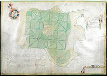
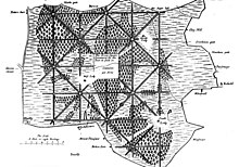
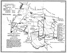
Enfield Chase is an area of Enfield that is named for a former royal hunting ground. It comprises the majority of the open countryside within the London Borough of Enfield, and land north of the M25 within Hertfordshire. At the time of a survey by Francis Russell in 1776-7, the Chase extended from Monken Hadley in the west to Bulls Cross in the east, and from Potters Bar to Southgate.
| Enfield Chase | |
|---|---|
Location within Greater London | |
| London borough | |
| Ceremonial county | Greater London |
| Region | |
| Country | England |
| Sovereign state | United Kingdom |
| Post town | ENFIELD |
| Postcode district | EN2 |
| Police | Metropolitan |
| Fire | London |
| Ambulance | London |
| London Assembly | |


While parts of the former area of the Chase including at Southgate, Oakwood, and Hadley Wood have been developed, areas that remain undeveloped include Trent Park, Whitewebbs Park, Hadley Common, Fir and Pond Wood near Potters Bar, and the valleys of the Salmons Brook, Turkey Brook, and Merryhills Brook, as well as golf courses at Hadley Wood and Whitewebbs. Remnants of the Chase now within the urban area of London include Chase Green near Enfield Town and Boxer's Lake Open Space in Oakwood.[4]
Etymology
editEnfield Chase was recorded as Enefeld Chacee in 1325 and chace of Enefelde in 1373, from the Middle English chace, meaning "a tract of ground for breeding and hunting wild animals".[5]
History
editIn the reign of Henry II the parish of Edmonton and adjoining parishes were for the most part a forest which was then so extensive that it reached from the City of London to about 12 miles (19 km) north. Enfield Chase was part of this forest and also belonged to the citizens of London.[6]
By 1154 what had been known as the Park of Enfield or Enfield Wood had been converted into a hunting ground, or chase. It appears it was not known as Enfield Chase until the early 14th century, by which time it was referred to as 'Parcus Extrinicus' (Latin, 'the Outer Park') to distinguish it from the older and smaller Enfield Old Park ('Parcus Intrinsicus' ('the Inner Park') which was mentioned in the Domesday Book as a park and was later used for rearing game to be released into the adjacent Chase.[7][8]
For hundreds of years the chase was owned at first by the Mandeville and then the de Bohun families while local inhabitants of Edmonton and Enfield manors claimed common rights. It is believed that Princess Elizabeth (later Queen Elizabeth I) often hunted on the Chase after she was granted the estate of West Lodge Park by her brother Edward VI in 1547.[5] In a charter of 1166-89 the hamlet of Southgate, sited around what is now Southgate Underground station, receives a mention. It takes its name from its location at the South Gate of the old hunting ground, later known as Enfield Chase.
| Enfield Chase Act 1777 | |
|---|---|
| Act of Parliament | |
| Long title | An Act for dividing the Chace of Enfield, in the County of Middlesex; and for other Purposes therein mentioned. |
| Citation | 17 Geo. 3. c. 17 |
| Dates | |
| Royal assent | 27 March 1777 |
By the Enfield Chase Act 1777 (17 Geo. 3. c. 17), the chase ceased to exist as an entity. According to a survey drawn up by the Duchy of Lancaster surveyor Francis Russell, the chase then covered an area of 8,349 acres (34 km2). According to the map accompanying the act, the Chase was cut up and divided among the following authorities:[6]
| To the King | 3,218 acres (13 km2) |
| To the Lodges | 313 acres (1.3 km2) |
| To the Enfranchised | 6 acres (24,000 m2) |
| To the Manor of Old Ford | 36 acres (150,000 m2) |
| To the Manor of Old Park | 30 acres (120,000 m2) |
| To South Mimms Parish | 1,026 acres (4 km2) |
| To Hadley Parish | 240 acres (1.0 km2) |
| To Enfield Parish | 1,732 acres (7 km2) |
| To Edmonton | 1,231 acres (5 km2) |
| To Tithe Owners | 519 acres (2.1 km2) |
The Chase after the Division of 1777
editBased on the map entitled Survey and Admeasurement of Enfield Chase by Francis Russell in 1776/7, the Chase extended from Monken Hadley in the west to Bulls Cross in the east, and from Potters Bar to Southgate.[9]
In 1777 George III leased the central part of the Chase to Sir Richard Jebb, his favourite doctor, as a reward for saving the life of the King's younger brother, the then Duke of Gloucester. This land later became Trent Park.[10]
The opening of Enfield station on the Great Northern line in 1871 (renamed Enfield Chase station in 1924 to avoid confusion with Enfield Town station) resulted in the first period of sustained housebuilding on former Chase lands. This began with 'artisan's cottages' built along Chase side in the 1880s and accelerated after the opening of new stations at Gordon Hill and Crews Hill in 1910.[11]
The grounds of South Lodge were acquired by developers Laing, who built a new housing estate in the period 1935-1939. Boxers Lake and Lakeside, once part of South Lodge, are the only remaining open spaces.[11][12]
In 1936-7 Middlesex County Council purchased around 4,000 hectares for inclusion in the Green Belt, which was drawn at the limits of urban development in 1939. Some of the land purchased became golf courses, whilst others, for example at Trent Park, Whitewebbs and Forty Hall, became public parks. The remainder of the Council-owned land was leased to tenant farmers.[13]
Enfield Chase Restoration Project
editIn what is London’s largest reforestation project, Thames21 is working in partnership with Enfield Council to restore 60 hectares in the Salmons Brook catchment, part of the greater River Lea catchment.[14] The first phase of the project, which commenced in autumn 2020 and was completed in 2022, involved the planting of 100,000 trees. It cost £1.3million in total, with £748,000 provided by the Mayor of London, £425,000 by the Forestry Commission, and £150,000 from the council itself.[15] In May 2022, the Enfield Chase Restoration Project won an award at the London Tree and Woodland Awards.[16] In April 2023, the Greater London Authority announced that it would provide another £500,000 in funding for further tree planting and improvements to footpaths at Enfield Chase.[17][18] The Friends of Enfield Chase group of local volunteers help to plant and maintain trees and undertake other practical conservation activities in the parts of the former Chase that are being 'restored'.[19]
Designation as an Area of Special Character
editThe Enfield Chase Heritage Area of Special Character (AoSC) was designated in 1994, following the recommendation of the Countryside Commission, English Nature, English Heritage and the London Ecology Unit, based on its combined landscape, historical and nature conservation interests. The AoSC is divided into a number of 'character areas' including the Salmons Brook Valley, the Turkey Brook Valley, the Merryhills Brook Valley, Clay Hill, the Theobalds Estate South, Whitewebbs and Forty Hall, Hornbeam Hills South (adjoining Hadley Wood) and Trent Park. The AoSC was designated in order to protect the existing character of Enfield Chase as an area comprising woodlands, streams, designed parklands and enclosed farmland.[20]
The Enfield Development Management Policies Development Plan Document (a statutory planning document), adopted in 2014, states in policy DMD84 that "new development within the Areas of Special Character will only be permitted if features or characteristics which are key to maintaining the character of the area are preserved or enhanced."[21]
Draft Enfield Local Plan proposes large-scale development
editIn June 2021 Enfield Council published for public consultation a draft Local Plan which proposed development with large parts of the Area of Special Character.[22] These areas included the following proposed development sites within undeveloped countryside of Enfield Chase:
- Land at Chase Park: 59.74 hectares proposed for approximately 3,000 new homes at greenfield/Green Belt land at Vicarage Farm and the Merryhills Way, land south of Enfield Road, and an extension at part of Rectory Farm owned by Enfield Council (pages 84–87; 347). The draft Policy states "development should facilitate the rewilding at Enfield Chase" (point 12, page 85).
- Land at Crews Hill: 82.4 hectares proposed for approximately 3,000 new homes including at Crews Hill Golf Course (owned by Enfield Council, designated as a Site of Borough Importance for Nature Conservation). (pages 75–780; 346)
- Land between Camlet Way and Crescent Way: 11.05 hectares of land owned by the Duchy of Lancaster (partly designated as a Borough Site of Importance for Nature Conservation) proposed for approximately 160 new homes (page 364)
- Land East of Junction 24: 11.08 hectares of land owned by Enfield Council, proposed for a minimum of 30,550sqm employment floorspace (light and general industrial, storage and distribution) including a co-ordinated employment offer on adjacent land also owned by Enfield Council within the Borough of Hertsmere in Hertfordshire (page 374).
In July 2021 the National Park City Foundation complained that Enfield Council was using the National Park City concept, mentioned several times in the draft Local Plan, as a 'bargaining chip' in Green Belt housing plans.[23]
In September 2022 the Council announced that a timetable for the next steps in the development plan would be published "early in 2023".[24] However as of May 2023 no timetable had been published. In May 2023 it was reported that cross-party talks to consider Green Belt development proposals had collapsed.[25]
See also
editReferences and sources
edit- References
- ^ Pam, David. (1984) The Story of Enfield Chase. Enfield: Enfield Preservation Society. p. 98. ISBN 0907318037
- ^ Dalling, Graham. (1996) Southgate and Edmonton Past: A Study in Divergence. London: Historical Publications. p. 16. ISBN 0948667346.
- ^ 1 item extracted from DL 41/1221 (formerly DL 41/96/26). 'A survey and Admeasurement of... National Archives. Retrieved 21 January 2019.
- ^ "Boxer's Lake Open Space". London Gardens Online.
- ^ a b Mills, A. D. (2010). A dictionary of London place-names (2nd ed.). Oxford: Oxford University Press. ISBN 9780199566785.
- ^ a b Pam, D. O. (1984). The story of Enfield Chase. Enfield: Enfield Preservation Society. ISBN 978-0907318033.
- ^ Haigh, Douglas, Old Park in the Manor of Enfield, London 1977
- ^ Baggs, A P; Bolton, Diane K; Scarff, Eileen P; Tyack, G C (1976), "Enfield: Growth before 1850, Volume 5, Hendon, Kingsbury, Great Stanmore, Little Stanmore, Edmonton Enfield, Monken Hadley, South Mimms, Tottenham, ed. T F T Baker and R B Pugh", www.british-history.ac.uk, London: British History Online, pp. 212–218
- ^ Ford, Edward (1873). A history of Enfield; the church history by G.H. Hodson and the general history by E. Ford. Retrieved 1 March 2023.
- ^ Mitellas, Alan, A Concise History of Trent Country Park
- ^ a b A P Baggs, Diane K Bolton, Eileen P Scarff and G C Tyack, 'Enfield: Growth after 1850', in A History of the County of Middlesex: Volume 5, Hendon, Kingsbury, Great Stanmore, Little Stanmore, Edmonton Enfield, Monken Hadley, South Mimms, Tottenham, ed. T F T Baker and R B Pugh (London, 1976), pp. 218-224. British History Online http://www.british-history.ac.uk/vch/middx/vol5/pp218-224 [accessed 3 March 2023].
- ^ Mullen, Michael Ann, Gardening on the Laing South Lodge Estate https://londongardenstrust.org/publications/enfield/4%20mam%20south%20lodge.pdf
- ^ Paine, M (2022), A History of Enfield Chase from its Origins to the Present Day, The Enfield Society
- ^ "Trees for rivers: A new woodland for London".
- ^ Enfield Dispatch, 30 March 2022
- ^ Enfield Dispatch, 30 May 2022
- ^ Enfield Dispatch, 19 April 2023
- ^ Greater London Authority, 18 April 2023
- ^ www.friendsofenfieldchase.org.uk
- ^ "Enfield Local Plan" (PDF). Enfield Council. 2013. Retrieved 3 March 2023.
- ^ "Development Management Document" (PDF). www.enfield.gov.uk. Enfield Council. 2014. Retrieved 3 March 2023.
- ^ Enfield Local Plan: Main Issues and Preferred Approaches, June 2021.
- ^ Enfield Dispatch, 20 July 2021
- ^ Council announcement regarding an update to the Local Development Scheme, September 2022.
- ^ Enfield Dispatch, 19 May 2023
- Sources
- Paine, M (2022) A History of Enfield Chase. The Enfield Society.
- Pam, D (1984) The Story of Enfield Chase. The Enfield Society.
- Delvin, S. (1988) A History of Winchmore Hill. Hyperion Press. ISBN 0-7212-0800-2.
- Newby, Herbert W. (1949) "Old" Southgate. London: T. Grove.
- Williams, Sally (2011) Notes on the Lodges and Estates of Enfield Chase, London Parks and Gardens Trust
External links
editMedia related to Enfield Chase at Wikimedia Commons
