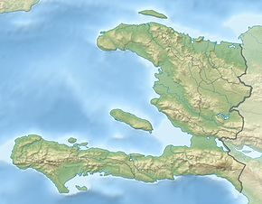
Some of the earthquakes in Haiti have been very destructive to the country. The widespread damage and high-number of casualties of events in 2010 and 2021 can be partially blamed on the fact that most of the population in Haiti resides in structures that are vulnerable to earthquake shaking, in which they are made of stone and concrete.[1]
Epicentres of major earthquakes in Haiti with year of occurrence
List of major earthquakes
| Date | Region | Mag. | MMI | Fatalities | Injuries | Comments | References |
|---|---|---|---|---|---|---|---|
| 2023-06-06 | Grand'Anse | 4.9 Mw | VII | 4 | 36 | Moderate damage | [2] |
| 2022-03-23 | Grand'Anse | 5.1 Mw | VIII | 5 | Minor damage | [3][4][5] | |
| 2022-01-24 | Nippes | 5.3 Mw | VII | 2 | 52 | Moderate damage | [6][7] |
| 2021-12-21 | Grand'Anse | 4.4 Mw | V | 150 | Additional damage/Aftershock | [8][9] | |
| 2021-08-14 | Nippes, Les Cayes | 7.2 Mw | VIII | 2,248 | 12,763 | Severe damage | [10][11] |
| 2018-10-07 | Port-de-Paix | 5.9 Mw | VI | 18 | 580 | Moderate damage | [12] |
| 2017-09-02 | Hinche | 4.3 Mw | IV | 1 | Minor damage | [13] | |
| 2011-06-24 | Port-au-Prince | 3.5 Mw | III | 7 | Injuries caused by stampede. | [14][15] | |
| 2010-01-12 | Port-au-Prince | 7.0 Mw | X | 100,000–316,000 | 300,000 | Extreme damage | |
| 1994-03-02 | Port-de-Paix | 5.4 Mw | V | 4 | Damaged houses | [16] | |
| 1964-04-20 | Nord | 6.6 Mw | VII | Significant damage | [17] | ||
| 1953-01-25 | 5.7 | 2 | Moderate damage | [18] | |||
| 1887-09-23 | Môle-Saint-Nicolas | Severe damage / tsunami | [19] | ||||
| 1864-05-19 | Jacmel | Moderate damage / tsunami | [20] | ||||
| 1860-04-08 | Anse-à-Veau | Moderate damage / tsunami | [21] | ||||
| 1842-05-07 | Cap-Haïtien | 8.1 Ms | 5,300 | Extreme damage / destructive tsunami | |||
| 1784-07-29 | Port-au-Prince–Léogâne–Petit-Goâve | Severe damage | [22] | ||||
| 1775-12-18 | Minimal damage / tsunami | [23] | |||||
| March 1775 | Minimal damage / tsunami | [24] | |||||
| 1770-06-03 | Port-au-Prince | 7.5 Mw | 250+ | Severe damage / tsunami | |||
| 1751-11-21 | Port-au-Prince | 8.0 Ms | Severe damage | ||||
| 1751-09-15 | Port-au-Prince | Moderate damage / tsunami | [25] | ||||
| 1701-11-09 | Léogâne–Petit-Goâve | Moderate damage | [26] | ||||
| 1562-12-02 | 7.7 MI | Concepción de la Vega destroyed | [27] | ||||
| Note: The inclusion criteria for adding events are based on WikiProject Earthquakes' notability guideline that was developed for stand alone articles. The principles described also apply to lists. In summary, only damaging, injurious, or deadly events should be recorded. | |||||||
See also
References
- ^ "PAGER". United States Geological Survey.
- ^ "M 4.9 – 9 km NE of Les Abricots, Haiti". United States Geological Survey. 6 June 2023. Retrieved 6 June 2023.
- ^ "M 5.1 – 18 km N of Jérémie, Haiti". United States Geological Survey.
- ^ "Haïti : Un séisme de magnitude 5.2 secoue le Grand Sud" [Haiti: A magnitude 5.2 earthquake shakes the Great South]. vantbefinfo.com (in French). 23 March 2022. Retrieved 24 March 2022.
- ^ "5.1 quake shakes southern Haiti; minor injuries reported". WTOP-FM. Associated Press. 23 March 2022. Retrieved 24 March 2022.
- ^ "M 5.3 – 3 km SSE of Anse-à-Veau, Haiti". United States Geological Survey.
- ^ "5.3 Magnitude Haiti Earthquake Destroys Over 200 Houses, 2 Killed". ndtv.com.
- ^ "M 4.4 – 9 km WSW of Corail, Haiti". United States Geological Survey. Retrieved 2022-08-21.
- ^ "Les remous de l'actualité". Le Nouvelliste (in French). Retrieved 2022-08-21.
- ^ "M 7.2 – 12 km NE of Saint-Louis du Sud, Haiti". United States Geological Survey.
- ^ Adrienne Vogt and Veronica Rocha (2021-08-14). "Live updates: 7.2 magnitude earthquake hits near Haiti". CNN. Retrieved 2021-08-14.
- ^ United Nations Office for the Coordination of Humanitarian Affairs (October 20, 2018). "Haiti: 2018 earthquake Situation report No.4" (PDF). Retrieved October 28, 2018.
- ^ "M 4.3 – 10 km WSW of Thomonde, Haiti". United States Geological Survey. September 2, 2017. Retrieved October 17, 2017.
- ^ "M 3.5 – 11 km N of Cayes-Jacmel, Haiti". United States Geological Survey.
- ^ "La terre tremble à Port-au-Prince". Le Devoir. June 25, 2011. Retrieved March 23, 2022.
- ^ "M5.4 – Haiti region". United States Geological Survey.
- ^ "M 6.6 – 68 km NNE of Borgne, Haiti". United States Geological Survey.
- ^ NGDC 1972
- ^ NGDC 1972
- ^ NGDC 1972
- ^ NGDC 1972
- ^ NGDC 1972
- ^ NGDC 1972
- ^ NGDC 1972
- ^ NGDC 1972
- ^ NGDC 1972
- ^ ten Brink, U.; Bakun, W. H.; Flores, C. H. (2011), "Historical perspective on seismic hazard to Hispaniola and the northeast Caribbean region" (PDF), Journal of Geophysical Research, 116 (B12), American Geophysical Union: 6–8, Bibcode:2011JGRB..11612318T, doi:10.1029/2011JB008497
Sources
- NGDC (1972), Significant Earthquake Database (Data Set), National Geophysical Data Center, NOAA, doi:10.7289/V5TD9V7K
