Camden-on-Gauley is a town in Webster County, West Virginia, United States, along the Gauley River. The population was 126 at the 2020 census.[2]
Camden-on-Gauley, West Virginia | |
|---|---|
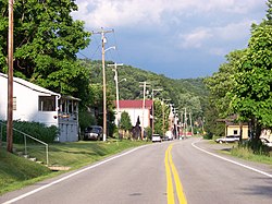
 Central Camden-on-Gauley | |
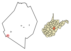
 Location of Camden-on-Gauley in Webster County, West Virginia. | |
| Coordinates: 38°22′8″N 80°35′47″W / 38.36889°N 80.59639°W | |
| Country | United States |
| State | West Virginia |
| County | Webster |
| Government | |
| • Mayor | Lisa Prather |
| Area | |
• Total | 0.33 sq mi (0.86 km2) |
| • Land | 0.33 sq mi (0.84 km2) |
| • Water | 0.01 sq mi (0.02 km2) |
| Population | |
• Total | 126 |
• Estimate (2021)[2] | 124 |
| • Density | 446.15/sq mi (172.21/km2) |
| Time zone | UTC-5 (Eastern (EST)) |
| • Summer (DST) | UTC-4 (EDT) |
| ZIP code | 26208 |
| Area code | 304 |
| FIPS code | 54-12436[3] |
| Website | https://local.wv.gov/CamdenOnGauley/Pages/default.aspx |
The town derives its name from Johnson N. Camden, a senator who was the proprietor of several businesses on the nearby Gauley River.[5] The town was originally called Lanes Bottom, but was changed to Camden-on-Gauley when incorporated in 1904.[4]
Geography
editCamden-on-Gauley is located at 38°22′8″N 80°35′47″W / 38.36889°N 80.59639°W (38.368782, -80.596459).[6]
According to the United States Census Bureau, the town has a total area of 0.34 square miles (0.88 km2), of which 0.33 square miles (0.85 km2) is land and 0.01 square miles (0.03 km2) is water.[7]
Demographics
edit| Census | Pop. | Note | %± |
|---|---|---|---|
| 1910 | 263 | — | |
| 1920 | 283 | 7.6% | |
| 1930 | 435 | 53.7% | |
| 1940 | 373 | −14.3% | |
| 1950 | 373 | 0.0% | |
| 1960 | 301 | −19.3% | |
| 1970 | 243 | −19.3% | |
| 1980 | 236 | −2.9% | |
| 1990 | 171 | −27.5% | |
| 2000 | 157 | −8.2% | |
| 2010 | 169 | 7.6% | |
| 2020 | 126 | −25.4% | |
| 2021 (est.) | 124 | [2] | −1.6% |
| U.S. Decennial Census[8] | |||
2010 census
editAs of the census[9] of 2010, there were 169 people, 70 households, and 48 families living in the town. The population density was 512.1 inhabitants per square mile (197.7/km2). There were 87 housing units at an average density of 263.6 per square mile (101.8/km2). The racial makeup of the town was 100.0% White.
There were 70 households, of which 30.0% had children under the age of 18 living with them, 45.7% were married couples living together, 15.7% had a female householder with no husband present, 7.1% had a male householder with no wife present, and 31.4% were non-families. 31.4% of all households were made up of individuals, and 7.1% had someone living alone who was 65 years of age or older. The average household size was 2.41 and the average family size was 2.94.
The median age in the town was 39.5 years. 20.1% of residents were under the age of 18; 8.3% were between the ages of 18 and 24; 32% were from 25 to 44; 24.3% were from 45 to 64; and 15.4% were 65 years of age or older. The gender makeup of the town was 50.3% male and 49.7% female.
2000 census
editAs of the census[3] of 2000, there were 157 people, 60 households, and 45 families living in the town. The population density was 442.0 inhabitants per square mile (168.4/km2). There were 83 housing units at an average density of 233.7 per square mile (89.0/km2). The racial makeup of the town was 99.36% White and 0.64% Native American.
There were 60 households, out of which 33.3% had children under the age of 18 living with them, 55.0% were married couples living together, 15.0% had a female householder with no husband present, and 25.0% were non-families. 21.7% of all households were made up of individuals, and 10.0% had someone living alone who was 65 years of age or older. The average household size was 2.62 and the average family size was 2.96.
In the town, the population was spread out, with 24.2% under the age of 18, 10.2% from 18 to 24, 25.5% from 25 to 44, 24.8% from 45 to 64, and 15.3% who were 65 years of age or older. The median age was 41 years. For every 100 females, there were 96.3 males. For every 100 females age 18 and over, there were 88.9 males.
The median income for a household in the town was $15,417, and the median income for a family was $21,250. Males had a median income of $27,188 versus $15,417 for females. The per capita income for the town was $9,137. About 30.6% of families and 39.2% of the population were below the poverty line, including 55.9% of those under the age of eighteen and 20.0% of those 65 or over.
References
edit- ^ "2019 U.S. Gazetteer Files". United States Census Bureau. Retrieved August 7, 2020.
- ^ a b c d "City and Town Population Totals: 2020-2021". Census.gov. US Census Bureau. Retrieved July 3, 2022.
- ^ a b "U.S. Census website". United States Census Bureau. Retrieved January 31, 2008.
- ^ a b West Virginia place names, their origin and meaning, including the nomenclature of the streams and mountains. The Place name press. 1945.
- ^ Kenny, Hamill (1945). West Virginia Place Names: Their Origin and Meaning, Including the Nomenclature of the Streams and Mountains. Piedmont, WV: The Place Name Press. p. 149.
- ^ "US Gazetteer files: 2010, 2000, and 1990". United States Census Bureau. February 12, 2011. Retrieved April 23, 2011.
- ^ "US Gazetteer files 2010". United States Census Bureau. Archived from the original on July 2, 2012. Retrieved January 24, 2013.
- ^ "Census of Population and Housing". Census.gov. Retrieved June 4, 2015.
- ^ "U.S. Census website". United States Census Bureau. Retrieved January 24, 2013.