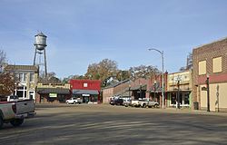
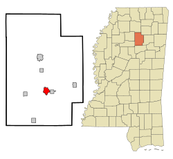
Calhoun City is a town in Calhoun County, Mississippi, United States. The population was 1,774 at the 2010 census.[2]
Calhoun City, Mississippi | |
|---|---|
 Calhoun City | |
 Location of Calhoun City, Mississippi | |
| Coordinates: 33°51′25″N 89°18′48″W / 33.85694°N 89.31333°W | |
| Country | United States |
| State | Mississippi |
| County | Calhoun |
| Area | |
• Total | 2.37 sq mi (6.15 km2) |
| • Land | 2.36 sq mi (6.11 km2) |
| • Water | 0.02 sq mi (0.04 km2) |
| Elevation | 282 ft (86 m) |
| Population (2020) | |
• Total | 1,533 |
| • Density | 650.40/sq mi (251.09/km2) |
| Time zone | UTC-6 (Central (CST)) |
| • Summer (DST) | UTC-5 (CDT) |
| ZIP codes | 38916, 38955 |
| Area code | 662 |
| FIPS code | 28-10580 |
| GNIS feature ID | 0667920 |
| Website | www |
Geography
editCalhoun City is located in south-central Calhoun County., and is bordered on the east by the town of Derma. Mississippi Highway 9 runs through the center of the town, leading north 6 miles (10 km) to Pittsboro, the county seat, and 10 miles (16 km) north to Bruce. Mississippi Highway 8 leads east from the center of town 8 miles (13 km) to Vardaman and 18 miles (29 km) to Houston. The two highways head south from the town together, Highway 9 leading 9 miles (14 km) south to Slate Springs and Highway 8 leading 31 miles (50 km) south then west to Grenada.
According to the United States Census Bureau, the town has a total area of 2.37 square miles (6.15 km2), of which 2.36 square miles (6.11 km2) is land and 0.02 square miles (0.04 km2), or 0.69%, is water.[2] The Yalobusha River, a tributary of the Yazoo River, passes a mile south of the center of town.
Climate
edit| Climate data for Calhoun City, Mississippi (1991–2020 normals, extremes 1915–1918, 1927, 1955–present) | |||||||||||||
|---|---|---|---|---|---|---|---|---|---|---|---|---|---|
| Month | Jan | Feb | Mar | Apr | May | Jun | Jul | Aug | Sep | Oct | Nov | Dec | Year |
| Record high °F (°C) | 81 (27) |
86 (30) |
91 (33) |
93 (34) |
96 (36) |
105 (41) |
104 (40) |
106 (41) |
104 (40) |
98 (37) |
90 (32) |
81 (27) |
106 (41) |
| Mean daily maximum °F (°C) | 53.8 (12.1) |
58.6 (14.8) |
67.0 (19.4) |
74.8 (23.8) |
81.9 (27.7) |
88.1 (31.2) |
91.1 (32.8) |
91.1 (32.8) |
86.4 (30.2) |
76.8 (24.9) |
64.8 (18.2) |
56.4 (13.6) |
74.2 (23.4) |
| Daily mean °F (°C) | 42.9 (6.1) |
46.9 (8.3) |
54.8 (12.7) |
62.7 (17.1) |
70.8 (21.6) |
77.9 (25.5) |
81.0 (27.2) |
80.4 (26.9) |
74.7 (23.7) |
63.8 (17.7) |
52.5 (11.4) |
45.6 (7.6) |
62.8 (17.1) |
| Mean daily minimum °F (°C) | 31.9 (−0.1) |
35.2 (1.8) |
42.6 (5.9) |
50.7 (10.4) |
59.7 (15.4) |
67.6 (19.8) |
71.0 (21.7) |
69.8 (21.0) |
63.0 (17.2) |
50.9 (10.5) |
40.2 (4.6) |
34.8 (1.6) |
51.4 (10.8) |
| Record low °F (°C) | −14 (−26) |
3 (−16) |
10 (−12) |
26 (−3) |
33 (1) |
42 (6) |
50 (10) |
47 (8) |
34 (1) |
24 (−4) |
11 (−12) |
−8 (−22) |
−14 (−26) |
| Average precipitation inches (mm) | 5.26 (134) |
5.16 (131) |
5.30 (135) |
6.20 (157) |
5.53 (140) |
5.43 (138) |
4.27 (108) |
3.67 (93) |
3.62 (92) |
3.62 (92) |
3.88 (99) |
5.96 (151) |
57.90 (1,471) |
| Average snowfall inches (cm) | 0.4 (1.0) |
0.3 (0.76) |
0.0 (0.0) |
0.0 (0.0) |
0.0 (0.0) |
0.0 (0.0) |
0.0 (0.0) |
0.0 (0.0) |
0.0 (0.0) |
0.0 (0.0) |
0.0 (0.0) |
0.1 (0.25) |
0.8 (2.0) |
| Average precipitation days (≥ 0.01 in) | 8.8 | 8.5 | 9.7 | 8.2 | 8.4 | 8.2 | 8.0 | 7.5 | 5.4 | 5.9 | 7.3 | 8.8 | 94.7 |
| Average snowy days (≥ 0.1 in) | 0.5 | 0.2 | 0.0 | 0.0 | 0.0 | 0.0 | 0.0 | 0.0 | 0.0 | 0.0 | 0.0 | 0.2 | 0.9 |
| Source: NOAA[3][4] | |||||||||||||
Demographics
edit| Census | Pop. | Note | %± |
|---|---|---|---|
| 1910 | 477 | — | |
| 1920 | 502 | 5.2% | |
| 1930 | 1,012 | 101.6% | |
| 1940 | 1,171 | 15.7% | |
| 1950 | 1,319 | 12.6% | |
| 1960 | 1,714 | 29.9% | |
| 1970 | 1,847 | 7.8% | |
| 1980 | 2,033 | 10.1% | |
| 1990 | 1,838 | −9.6% | |
| 2000 | 1,872 | 1.8% | |
| 2010 | 1,774 | −5.2% | |
| 2020 | 1,533 | −13.6% | |
| U.S. Decennial Census[5] | |||
2020 census
edit| Race | Num. | Perc. |
|---|---|---|
| White | 793 | 51.73% |
| Black or African American | 630 | 41.1% |
| Asian | 1 | 0.07% |
| Other/Mixed | 69 | 4.5% |
| Hispanic or Latino | 40 | 2.61% |
As of the 2020 United States Census, there were 1,533 people, 709 households, and 436 families residing in the town.
2000 census
editAs of the census[7] of 2000, there were 1,872 people, 736 households, and 530 families residing in the town. The population density was 789.1 inhabitants per square mile (304.7/km2). There were 827 housing units at an average density of 348.6 per square mile (134.6/km2). The racial makeup of the town was 66.72% Caucasian, 32.00% African American, 0.11% Native American, 0.05% Asian, 0.16% from other races, and 0.96% from two or more races. Hispanic or Latino of any race were 0.69% of the population.
There were 736 households, out of which 34.5% had children under the age of 18 living with them, 44.3% were married couples living together, 23.6% had a female householder with no husband present, and 27.9% were non-families. 26.4% of all households were made up of individuals, and 15.6% had someone living alone who was 65 years of age or older. The average household size was 2.38 and the average family size was 2.84.
In the town, the population was spread out, with 25.1% under the age of 18, 8.1% from 18 to 24, 23.2% from 25 to 44, 21.6% from 45 to 64, and 22.0% who were 65 years of age or older. The median age was 39 years. For every 100 females, there were 73.0 males. For every 100 females age 18 and over, there were 66.4 males.
The median income for a household in the town was $23,983, and the median income for a family was $28,047. Males had a median income of $27,917 versus $20,292 for females. The per capita income for the town was $14,294. About 23.2% of families and 25.2% of the population were below the poverty line, including 41.1% of those under age 18 and 16.9% of those age 65 or over.
Education
editCalhoun City is served by the Calhoun County School District. Calhoun City High School's athletic teams are known as the Wildcats.
In 1968, Calhoun Academy was formed as a segregation academy by white parents seeking to avoid sending their children to racially integrated public schools.[8] Its sports teams are known as the Cougars.
Notable people
edit- Ace Cannon, saxophone player and Mississippi Musicians Hall of Fame inductee
- Billy Cowan, former Major League Baseball player[9]
- M. D. Jennings, defensive back for the Green Bay Packers
- Vester Newcomb, former National Football League player and head football coach of University of Tennessee at Martin from 1978 to 1979[10]
- Dave Parker, former Major League Baseball player
- Scott Suber, former Mississippi State first-team All-American[11]
- Cornelius Wortham, former National Football League and Alabama Crimson Tide player
- Perry Van Bailey, member of the Mississippi House of Representatives (2023–present)
References
edit- ^ "2020 U.S. Gazetteer Files". United States Census Bureau. Retrieved July 24, 2022.
- ^ a b "Geographic Identifiers: 2010 Demographic Profile Data (G001): Calhoun City town, Mississippi". U.S. Census Bureau, American Factfinder. Archived from the original on February 12, 2020. Retrieved October 2, 2014.
- ^ "NOWData - NOAA Online Weather Data". National Oceanic and Atmospheric Administration. Retrieved November 3, 2023.
- ^ "Summary of Monthly Normals 1991-2020". National Oceanic and Atmospheric Administration. Retrieved November 3, 2023.
- ^ "Census of Population and Housing". Census.gov. Retrieved June 4, 2015.
- ^ "Explore Census Data". data.census.gov. Retrieved December 8, 2021.
- ^ "U.S. Census website". United States Census Bureau. Retrieved January 31, 2008.
- ^ Drinkwater Jr, W. Wayne, and Charles Claiborne Barksdale. Cook v. Hudson: The State's Interest in Integration versus the First Amendment Rights on the Public Schoolteacher Miss. LJ 45 (1974): 953.
- ^ Peter C. Bjarkman (March 2002). The New York Mets Encyclopedia. Sports Publishing LLC. p. 1917. ISBN 978-1-58261-509-7.
- ^ "Vester Newcomb Obit". Enterprise-Journal. McComb (MS) Enterprise-Journal. October 9, 2009. pp. A003. Retrieved May 18, 2020.
- ^ "Billie Suber". Mississippi Sports Hall of Fame. Retrieved May 19, 2020.


