This article needs additional citations for verification. (February 2024) |
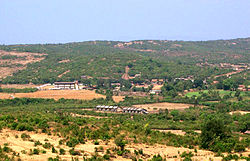
Amboli is a small village in the southern Konkan Division, Sindhudurg district, Maharashtra state, India. Amboli Ghat lies at an altitude of approximately 700 metres (2,300 feet) above sea level and is the last hill resort before ending in the coastal plains of Goa state.[1]
Amboli | |
|---|---|
Village | |
 Amboli Hill Station | |
| Coordinates: 15°57′45″N 73°59′52″E / 15.96250°N 73.99778°E | |
| Country | |
| State | Maharashtra |
| District | Sindhudurg |
| Government | |
| • Sarpahch | savitri palekar |
| Population (2001) | |
• Total | 4,004 |
| Language | |
| • Official | Marathi |
| Time zone | UTC+5:30 (IST) |
| Telephone code | 02363 |
| Vehicle registration | MH-07 |
| Website | ambilihillstation.In |
Amboli lies in the Western Ghats of peninsular India, one of the world's "Ecological Hotspots"[citation needed] and it abounds in unusual flora and fauna. However, as in the other parts of the Sahaydri Hills, denudation of the forest cover and unregulated government-assisted development are gradually ruining a once-pristine environment.[original research?]
Historically, Amboli village came into being as one of the staging posts along the road from Vengurla port to the city of Belgaum, which was extensively used by the British to supply their garrisons in south and central India.
The source of the Hiranyakeshi river lies in the hills around Amboli village and farmers cultivate rice in it.[2] An ancient Shiva temple (called Hiranyakeshwar) sits at the cave where the water emerges.[citation needed] The main attraction for tourists is the incredibly-high rainfall (7 m average, per year) and the numerous waterfalls and mist during the monsoons. Legend has it that there are 108 Shiva temples in and around Amboli, of which only a dozen have been uncovered, one as recently as 2005.[citation needed] Amboli is also known for sending large number of youngsters to serve Indian Army. In Amboli, it is hard to find a house which doesn't have at least one person who is serving in Indian Army or has served Indian Army. Shahid Soldier Pandurang Mahadev Gawade was also from Amboli, who attained martyrdom while fighting five Lashkar terrorists at Drug Mulla village in Kashmir's Kupwara district on May 22, 2016, was posthumously awarded Shaurya Chakra on the eve of 68th Republic Day. Additionally, the interesting fact of the village is that many men had also served for British army in the pre-independence era.
Transport
editAmboli is well connected by road to the surrounding cities of Kolhapur (128 km (80 mi)), Belgavi 68 km (42 mi), and Panjim (90 km (56 mi)) by road.The nearest airport is Belgavi Airport.
Accommodation
editThere are a few hotels at Amboli. Most of them provide hot water baths and have facilities like restaurant, room service and cab services.
Local transport
editThe only local transport is motorised three-wheeler rickshaws and a couple of private taxis.
Tourist attractions
editThere are in total 8 places that are listed by Maharashtra Tourism Development Corporation (MTDC). Amboli Waterfall, Hiranyakeshi(Shiv Mandir and ancient cave), Kavalesat (Reverse waterfall point), Amboli Forest (Rich with flora and fauna), Ganesh Kond(waterway/river), and the entire area is full of greenery and beautiful sceneries. People at the village are highly dependent on farming for daily livelihood, as a results, entire village is surrounded by rice plantation during the rainy season. People are very simple and helpful. Similarly, Amboli has several hotels and resorts but it is preferable to stay with locals and try local cuisine.
Natural Wonders
editSunset Point is a popular viewpoint in Amboli. It offers mesmerising views of the sun setting over the lush green valleys and hills of the Western Ghats. The point is located about 1 km from the Amboli Bus Stand towards Sawantwadi.
Nearest cities
edit- Sawantwadi — 29 km (18 mi)
- Kudal — 47 km (29 mi)
- Kolhapur — 129 km (80 mi) via the Gadhinglaj–Sankeshwar main road
- Sangli — 152 km (94 mi) via the Gadhinglaj–Chikodi–Miraj
- Belgavi — 68 km (42 mi)
- Ajara — 32 km (20 mi)
- Chandgad — 29 km (18 mi)
- Gadhinglaj — 52 km (32 mi)
Nearest railway stations
edit- Sawantwadi Road railway station — 28 km (17 mi)
- Kudal railway station — 47 km (29 mi)
- Pernem railway station — 58 km (36 mi)
- Belagavi railway station — 70 km (43 mi)
- Chhatrapati Shahu Maharaj Terminus — 110 km (68 mi)
- Sangli railway station — 130 km (81 mi)
- Miraj Junction railway station — 140 km (87 mi)
- Madgaon Junction railway station — 140 km (87 mi)
Tourists coming from Mumbai, Goa, Delhi and trains on the Konkan railway can reach Amboli from Sawantwadi railway station. There are buses from Karnataka State Road Transport Corporation and Maharashtra State Road Transport Corporation that travel frequently between Belgaum and Sawantwadi via Amboli. Private cars are available from Sawantwadi railway station to Amboli. Buses travel to Amboli from Sangli and Kolhapur stations via Nippani–Gadhinglaj–Ajara.
Gallery
edit-
Waterfall in Amboli
References
edit- ^ Wright, Gillian (1991). Hill Stations of India. Odyssey. p. 216. ISBN 978-962-217-137-4. Retrieved 20 February 2024.
- ^ Kumkar, Pradeep; Kharat, Sanjay S.; Sawant, Nitin S.; Katwate, Unmesh; Dahanukar, Neelesh (26 May 2017). "Freshwater fish fauna of Hiranyakeshi River, the northern Western Ghats, India". Journal of Threatened Taxa. 9 (5): 10178–10186. doi:10.11609/jott.3126.9.5.10178-10186. Retrieved 20 February 2024.
External links
edit- Information page
- Map of Amboli Hill Station
- Amboli travel guide from Wikivoyage
