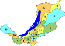
Administrative divisions of Buryatia
(Redirected from Administrative divisions of the Republic of Buryatia)
| Republic of Buryatia, Russia | |
|---|---|
| Capital: Ulan-Ude | |
| As of 2013:[1] | |
| Number of districts (районы) |
21 |
| Number of cities/towns (города) |
6 |
| Number of urban-type settlements (посёлки городского типа) |
16 |
| Number of selsoviets and somons (сельсоветы и сомоны) |
238 |
| As of 2002:[2] | |
| Number of rural localities (сельские населённые пункты) |
611 |
| Number of uninhabited rural localities (сельские населённые пункты без населения) |
5 |

Administrative and municipal divisions
edit| Division | Structure | OKATO | OKTMO | Urban-type settlement/ district-level town* |
Rural | ||
|---|---|---|---|---|---|---|---|
| Administrative | Municipal | ||||||
| Ulan-Ude (Улан-Удэ) | city | urban okrug | 81 401 | 81 701 | |||
| ↳ | Oktyabrsky (Октябрьский) | (under Ulan-Ude) | — | 81401 | — | ||
| ↳ | Sovetsky (Советский) | (under Ulan-Ude) | — | 81401 | — | ||
| ↳ | Zheleznodorozhny (Железнодорожный) | (under Ulan-Ude) | — | 81401 | — | ||
| Severobaykalsk (Северобайкальск) | city | urban okrug | 81 420 | 81 720 | |||
| Barguzinsky (Баргузинский) | district | 81 203 | 81 603 |
|
| ||
| Bauntovsky (Баунтовский) | district | 81 206 | 81 606 |
| |||
| Bichursky (Бичурский) | district | 81 209 | 81 609 |
| |||
| Dzhidinsky (Джидинский) | district | 81 212 | 81 612 |
|
| ||
| Yeravninsky (Еравнинский) | district | 81 215 | 81 615 |
| |||
| Zaigrayevsky (Заиграевский) | district | 81 218 | 81 618 |
|
| ||
| Zakamensky (Закаменский) | district | 81 221 | 81 621 |
|
| ||
| Ivolginsky (Иволгинский) | district | 81 222 | 81 622 |
| |||
| Kabansky (Кабанский) | district | 81 224 | 81 624 |
|
| ||
| Kizhinginsky (Кижингинский) | district | 81 227 | 81 627 |
| |||
| Kurumkansky (Курумканский) | district | 81 230 | 81 630 |
| |||
| Kyakhtinsky (Кяхтинский) | district | 81 233 | 81 633 |
| |||
| Muysky (Муйский) | district | 81 235 | 81 635 |
|
| ||
| Mukhorshibirsky (Мухоршибирский) | district | 81 236 | 81 636 |
| |||
| Okinsky (Окинский) | district | 81 239 | 81 639 |
| |||
| Pribaykalsky (Прибайкальский) | district | 81 242 | 81 642 |
| |||
| Severo-Baykalsky (Северо-Байкальский) | district | 81 245 | 81 645 |
|
| ||
| Selenginsky (Селенгинский) | district | 81 248 | 81 648 |
|
| ||
| Tarbagataysky (Тарбагатайский) | district | 81 250 | 81 650 |
| |||
| Tunkinsky (Тункинский) | district | 81 251 | 81 651 |
| |||
| Khorinsky (Хоринский) | district | 81 257 | 81 657 |
| |||
Note on the types of the inhabited localities
editIn the Republic of Buryatia, ulus is a type of rural locality, along with "selo" and "settlement".[3]
References
edit- ^ Государственный комитет Российской Федерации по статистике. Комитет Российской Федерации по стандартизации, метрологии и сертификации. №ОК 019-95 1 января 1997 г. «Общероссийский классификатор объектов административно-территориального деления. Код 81», в ред. изменения №278/2015 от 1 января 2016 г.. (State Statistics Committee of the Russian Federation. Committee of the Russian Federation on Standardization, Metrology, and Certification. #OK 019-95 January 1, 1997 Russian Classification of Objects of Administrative Division (OKATO). Code 81, as amended by the Amendment #278/2015 of January 1, 2016. ).
- ^ Results of the 2002 Russian Population Census—Territory, number of districts, inhabited localities, and rural administrations of the Russian Federation by federal subject Archived September 28, 2011, at the Wayback Machine
- ^ Закон Республики Бурятия №2433-III "Об административно-территориальном устройстве Республики Бурятия" от 10 сентября 2007 г. (Law of the Republic of Buryatia #2433-III of September 10, 2007 On the Administrative and Territorial Structure of the Republic of Buryatia.