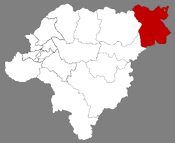
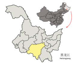
Yilan County (simplified Chinese: 依兰县; traditional Chinese: 依蘭縣; pinyin: Yīlán Xiàn; IPA: [í.lǎn ɕjɛ̂n]) is a county of Heilongjiang Province, Northeast China, it is under the administration of the prefecture-level city of Harbin, the capital of Heilongjiang. It is more than 240 kilometres (150 mi) to the east-northeast of central Harbin. Its county seat, which is also called Yilan (Yilan Town, Yilan zhen), is located near the confluence of the Mudan River (formerly known as the Hurka River) with the Sungari. The easternmost county-level division of Harbin City, it borders Fangzheng County to the southwest, Tonghe County to the west, as well as the prefecture-level cities of Yichun to the north, Jiamusi to the northeast, Qitaihe to the southeast, and Mudanjiang to the south.
Yilan County
依兰县 I-lan | |
|---|---|
 Location of Yilan in Harbin | |
 Harbin in Heilongjiang | |
| Coordinates: 46°19′01″N 129°33′43″E / 46.317°N 129.562°E[1] | |
| Country | People's Republic of China |
| Province | Heilongjiang |
| Sub-provincial city | Harbin |
| Area | |
• Total | 4,616.0 km2 (1,782.2 sq mi) |
| Elevation | 97 m (321 ft) |
| Population (2010)[3] | |
• Total | 388,319 |
| • Density | 84/km2 (220/sq mi) |
| Time zone | UTC+8 (China Standard) |
| Postal code | 1548XX |
| Website | hrbyl |
Transportation
editStation on the Harbin-Jiamusi intercity railway is located in the Sijianfang district, 5 km from town center.
History
editDuring the rule of the Ming dynasty in China, Yilan, formerly known as Sanxing (三姓; Wade–Giles: San-hsing; historically also Romanized as San Sing[4]), was one of the two important centers of the Jianzhou Jurchens of the Hurka River valley. (The other center was Ninguta in the upper reaches of the Hurka).[5] Its Jurchen name was Ilantumen.[6]
The town retained its importance into the Qing period, and in 1692 became the seat of a deputy lieutenant-general (副都統; fù dūtǒng). Subordinated to the governor general (jiangjun) in Jilin City. the Sanxing fu dutong was in control of the northeastern section of Jilin Province (which in those days was much larger than now) – a large region stretching northeast along the Sungari and the Amur to the Pacific Ocean.[7]
In 1887, three British travelers – H. E. M. James, Francis Younghusband and Harry English Fulford – visited Sanxing on their tour of Manchuria. According to Fulford's account, the town had the population of around 10,000, trade in furs and fish (salmon and sturgeon) being its main industries.[4]
Lu Houmin, who was the official photographer for the top Chinese leaders particularly Mao Zedong from 1950 to 1964 was born in Yilan.[8]
Climate
edit| Climate data for Yilan (1991–2020 normals, extremes 1971–2010) | |||||||||||||
|---|---|---|---|---|---|---|---|---|---|---|---|---|---|
| Month | Jan | Feb | Mar | Apr | May | Jun | Jul | Aug | Sep | Oct | Nov | Dec | Year |
| Record high °C (°F) | 2.0 (35.6) |
9.0 (48.2) |
20.2 (68.4) |
29.4 (84.9) |
34.3 (93.7) |
37.4 (99.3) |
37.8 (100.0) |
37.2 (99.0) |
30.6 (87.1) |
27.0 (80.6) |
16.3 (61.3) |
6.1 (43.0) |
37.8 (100.0) |
| Mean daily maximum °C (°F) | −12.3 (9.9) |
−6.5 (20.3) |
2.4 (36.3) |
13.1 (55.6) |
20.7 (69.3) |
25.4 (77.7) |
27.6 (81.7) |
25.9 (78.6) |
21.0 (69.8) |
11.9 (53.4) |
−0.8 (30.6) |
−10.8 (12.6) |
9.8 (49.7) |
| Daily mean °C (°F) | −17.2 (1.0) |
−12.4 (9.7) |
−3.5 (25.7) |
6.6 (43.9) |
14.3 (57.7) |
19.6 (67.3) |
22.6 (72.7) |
20.7 (69.3) |
14.5 (58.1) |
5.8 (42.4) |
−5.5 (22.1) |
−15.2 (4.6) |
4.2 (39.5) |
| Mean daily minimum °C (°F) | −21.5 (−6.7) |
−18.0 (−0.4) |
−9.3 (15.3) |
0.4 (32.7) |
8.0 (46.4) |
14.3 (57.7) |
18.0 (64.4) |
16.3 (61.3) |
8.9 (48.0) |
0.5 (32.9) |
−9.7 (14.5) |
−19.1 (−2.4) |
−0.9 (30.3) |
| Record low °C (°F) | −35.0 (−31.0) |
−31.8 (−25.2) |
−26.9 (−16.4) |
−12.6 (9.3) |
−4.1 (24.6) |
4.8 (40.6) |
10.6 (51.1) |
7.0 (44.6) |
−3.0 (26.6) |
−13.2 (8.2) |
−25.7 (−14.3) |
−32.9 (−27.2) |
−35.0 (−31.0) |
| Average precipitation mm (inches) | 4.8 (0.19) |
4.8 (0.19) |
14.5 (0.57) |
24.6 (0.97) |
56.9 (2.24) |
83.1 (3.27) |
138.3 (5.44) |
131.4 (5.17) |
61.7 (2.43) |
31.1 (1.22) |
15.3 (0.60) |
10.0 (0.39) |
576.5 (22.68) |
| Average precipitation days (≥ 0.1 mm) | 5.1 | 4.3 | 7.4 | 8.4 | 12.3 | 13.5 | 13.8 | 13.5 | 9.9 | 7.7 | 6.6 | 7.4 | 109.9 |
| Average snowy days | 7.2 | 5.9 | 8.1 | 3.2 | 0.1 | 0 | 0 | 0 | 0 | 1.8 | 7.9 | 9.6 | 43.8 |
| Average relative humidity (%) | 71 | 66 | 61 | 57 | 61 | 72 | 80 | 83 | 77 | 66 | 68 | 72 | 70 |
| Mean monthly sunshine hours | 147.8 | 177.5 | 212.4 | 204.4 | 225.6 | 224.5 | 222.0 | 216.6 | 219.3 | 186.6 | 147.2 | 134.9 | 2,318.8 |
| Percent possible sunshine | 53 | 60 | 57 | 50 | 49 | 48 | 47 | 50 | 59 | 56 | 53 | 51 | 53 |
| Source 1: China Meteorological Administration[9][10] | |||||||||||||
| Source 2: Weather China[11] | |||||||||||||
Administrative divisions
editYilan County is divided into 6 towns, 2 townships and 1 ethnic township.[12]
- 6 towns
- Yilan (依兰镇), Dalianhe (达连河镇), Jiangwan (江湾镇), Sandaogang (三道岗镇), Daotaiqiao (道台桥镇), Hongkeli (宏克利镇)
- 2 townships
- Tuanshanzi (团山子乡), Yugong (愚公乡)
- 1 ethnic township
- Yinglan Korean (迎兰朝鲜族乡)
References
edit- ^ "Yilan" (Map). Google Maps. Retrieved 2014-07-02.
- ^ Harbin Statistical Yearbook 2011 (《哈尔滨统计年鉴2011》). Accessed 8 July 2014.
- ^ 2010 Census Harbin primary statistics report (《哈尔滨市2010年第六次全国人口普查主要数据公报》). Accessed 8 July 2014.
- ^ a b Fulford, H. (1887), "Mr. Fulford's Journeys in Manchuria", Scottish Geographical Magazine, 3, Royal Scottish Geographical Society.
- ^ Lattimore, Owen (2008). Manchuria – Cradle of Conflict. Modern reprint by READ BOOKS. pp. 14, 33. ISBN 978-1-4437-2496-8.
- ^ Crossley, Pamela Kyle (2000). A Translucent Mirror: History and Identity in Qing Imperial Ideology. Berkeley: University of California Press. p. 75. ISBN 9780585371108.
- ^ 吉林省历史沟沉 [An exploration of the history of Jilin Province]. Chinese Academy of Social Sciences.. There is also same article converted to HTML by Google[dead link]
- ^ "Chairman Mao's personal cameraman dies". shanghaiist. 10 March 2015.
- ^ 中国气象数据网 – WeatherBk Data (in Simplified Chinese). China Meteorological Administration. Retrieved 5 July 2023.
- ^ 中国气象数据网 (in Simplified Chinese). China Meteorological Administration. Retrieved 5 July 2023.
- ^ 依兰 – 气象数据 -中国天气网 (in Chinese). Weather China. Retrieved 23 August 2022.
- ^ "国家统计局 2019" (in Chinese). National Bureau of Statistics of the People's Republic of China. Retrieved 2021-12-07.