Sir William Hannah McLean, KBE (1877–1967[2]), was a British engineer, colonial development specialist, colonial administrator, and politician.

Educated privately and at Glasgow University, McLean trained as a civil engineer, then joined the Sudan Civil Service in 1906, where he came into contact with Lord Kitchener over the planning of Khartoum, for whose layout he was responsible.[3][4] At the request of Kitchener, he transferred to the Egyptian Civil Service in 1913 and became Engineer-in-Chief, Ministry of Interior, where he planned Alexandria and initiated the national and regional development planning scheme for Egypt. During the First World War, he was in charge of the protection of town water supplies in Egypt.
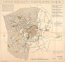
In 1918, he prepared a protective urban planning scheme for Jerusalem, which was approved by Lord Allenby. He divided Jerusalem into four zones:[3]
- the Old City, in which a ‘‘medieval aspect’’ was to be preserved through the prohibition of all new construction;
- a zone of non-construction around the Old City, where undesirable buildings would be cleared and the area left to its natural state;
- an area to the north and east of the Old City, where buildings could be erected only with special approval; and
- an area to the north and west of the Old City that was set aside for modern development.
He retired from the Egyptian Civil Service in 1926 and returned to Glasgow University, where he engaged in technical and economic research in regional planning, for which he was awarded a PhD in 1929.
He was a Scottish Unionist Party member of the House of Commons of the United Kingdom for Glasgow Tradeston between the general elections of 1931 and 1935. In 1938, he was appointed Commander of the Venerable Order of the Hospital of St. John of Jerusalem.[5]
He was a member of the advisory committee on education in the colonies and of the educational commission to East Africa of 1937. He was appointed KBE in 1938. From 1931 onward, he dedicated much of his effort to the spreading of information about British colonial policy. During the Second World War, he worked on a voluntary and unpaid basis for the Information Department of the Colonial Office, producing factual memoranda about colonial administration and development for the information of parliamentarians.
References
edit- ^ Elisha Efrat and Allen G. Noble, Planning Jerusalem, Geographical Review, Vol. 78, No. 4 (Oct., 1988), pp. 387-404: "Modern planning began only after the British conquest of Palestine in World War I… In 1918 an engineer from Alexandria, William McLean, was commissioned to draft the first city plan… These provisions… caused the city to develop mainly to the west and southwest because of the restrictions on construction in the Old City and its immediate environs and the desire to retain the eastern skyline… McLean wanted Jerusalem to expand to the north, west, and south, with little development to the east because of climatic and topographical limitations. Thus almost from the onset of British colonial rule, development was encouraged in a generally westward direction, and this bias ultimately produced the initial contrasts that distinguished the eastern and western sectors of the city. McLean also adopted the principle of urban dispersal, and he proposed two main axes, one to the northwest and the other to the southwest of the Old City. His guidelines were repeated in most of the subsequent city plans."
- ^ Leigh Rayment's Historical List of MPs – Constituencies beginning with "T" (part 2)
- ^ a b Roberts213, Nicholas E. (2013). "Dividing Jerusalem: British Urban Planning in the Holy City" (PDF). JSTOR. doi:10.1525/JPS.2013.42.4.7. S2CID 156587484. Archived (PDF) from the original on 13 February 2020. Retrieved 25 August 2020.
{{cite journal}}: CS1 maint: numeric names: authors list (link) - ^ Grinsell, Sam (30 July 2020). "The city is a lie". Aeon.
- ^ "London Gazette" (PDF). London Gazette. 24 June 1938. Retrieved 24 August 2020.
External links
edit