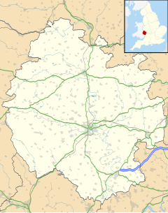
Weston under Penyard is a small village in Herefordshire, England. The population of the civil parish at the 2011 Census was 1,007.[1]
| Weston under Penyard | |
|---|---|
 | |
 | |
Location within Herefordshire | |
| Population | 1,007 (2011 Census) |
| Unitary authority | |
| Shire county | |
| Region | |
| Country | England |
| Sovereign state | United Kingdom |
| Post town | Ross-on-Wye |
| Postcode district | HR9 |
| Police | West Mercia |
| Fire | Hereford and Worcester |
| Ambulance | West Midlands |
| UK Parliament | |
It lies on the A40 road two miles east of Ross-on-Wye. The Penyard is a prominent hill.
History
editThe parish church of St Lawrence has a tall 14th-century west tower which had a spire until it was damaged by lightning in 1750.[2]
A Wesleyan chapel was constructed at Buryhill during the early 19th century but was disused by 1964.[3] The building was subsequently converted for use as private residence.[4]
Slightly to the east under farmland lies the former Roman settlement of Ariconium, which gave its name to the historical Welsh Kingdom spanning areas of what is now known as Herefordshire Ergyng and Archenfield. The name Ariconium is Romano-British and may conceivably have an equivalent in or near the Roman province of Galatia.
Herefordshire escaped most of the battles with the Vikings but in 914 the Danes made additional visits to the area and ravaged Archenfield, according to the Anglo-Saxon Chronicle (AD 915, Worcester Manuscript, p. 99). The jarls leading the raids, Ohtor and Hroald, captured Bishop Cameleac or Cyfeiliog, then the Bishop of Llandaff; he was later ransomed. The jarls were killed in a subsequent battle at "Kill Dane Field" in Weston-under-Penyard and the raiders were subdued.[5]
Two miles south west are the fragmentary remains of Penyard Castle, a fourteenth-century castle on the site of which was built a seventeenth-century house. Penyard House is a Georgian building that used to operate as a hotel.
Notable people
editRichard Amerike (c. 1445–1503), a Bristol merchant, was born in the village, and some sources suggest gave his name to America.[6] Marc Bolan, the singer and guitarist, owned the Old Rectory in the 1970s.[7] Richard Hammond, the former Top Gear presenter, has a home, Bollitree Castle, in the village.[8] It comprises a house built circa 1700 incorporating the remains of an earlier building, to which castellated walls, turrets and moat were added in the late eighteenth century.
Transport
editWeston under Penyard Halt was a former station on the Hereford, Ross and Gloucester Railway on the section between Ross-on-Wye and Grange Court and thence to Gloucester. Opened in 1929 to compete with local road transport[9] it was located on the Great Western Railway line linking Ross-on-Wye and Gloucester. Nothing remains of the station.[10]
References
edit- ^ "Civil Parish population 2011". Retrieved 1 November 2015.
- ^ "Weston-under-Penyard - British History Online". www.british-history.ac.uk.
- ^ "No. 43225". The London Gazette. 21 January 1964.
- ^ "Property history - The Old Chapel, Bury Hill, Weston Under Penyard, Ross-On-Wye HR9 7PS - Marketed for sale on 21st Jul 2011 - Zoopla". www.zoopla.co.uk.
- ^ "The Vikings in Herefordshire". Herefordshire. 13 July 2014. Retrieved 24 November 2019.
Other than this there is very little mention of Viking presence in the county, and we are distinctly lacking in Viking place-names or settlements that were characteristic of places elsewhere in the country where the Norsemen's presence was more noticeably felt.
- ^ MacDonald, Peter (29 March 2011). "BBC - History - The Naming of America". BBC News. Retrieved 18 November 2024.
- ^ Hughes, Janet (2 October 2021). "The truth about Marc Bolan's Herefordshire home". Gloucestershire Live. Retrieved 18 November 2024.
- ^ "Richard Hammond's plan to alter castle home falls through". BBC News. 20 May 2023. Retrieved 18 September 2023.
- ^ Smith, WH (1998) Herefordshire Railways Book, Sutton Publishing p. 25.
- ^ Cross, AG (1982) Old Industrial Sites in Wyedean, A Gazeteer, Mills Archive. p. 106.
External links
edit- Map sources for Weston under Penyard
- Herefordshire County Council page
- No longer extant reference - Weston under Penyard on the Wyenot website
- Weston under Penyard at Vision of Britain
- Old photos of Weston under Penyard
